

Ready to explore Parc National Des Monts-valin? Here's everything you need to know before you go!
Discover the trail


Available trails
| Trails | Distance | Elevation | Duration | Difficulty | GPX |
|---|---|---|---|---|---|
| 3 km | 50 m | 45min | Beginner | ||
| 7.5 km | 70 m | 2h | Beginner | ||
| 5 km | 100 m | 1h30 | Beginner | ||
| 3 km | 275 m | 1h | Intermediate | ||
| 5.5 km | 1h30 | Intermediate | |||
| 4.5 km | 1h | Intermediate | |||
| 7 km | 830 m | 3h | Intermediate | ||
| 4 km | 420 m | 1h30 | Intermediate | ||
| 2 km | 670 m | 1h30 | Advanced | ||
| 2.5 km | 340 m | 1h | Advanced | ||
| 12 km | 110 m | 3h | Advanced | ||
| 6.5 km | 1h30 | Advanced | |||
| 2 km | 590 m | 1h30 | Advanced |
Trail description
Description
Monts Valin National Park sprawls across 153.7 square kilometers of rugged wilderness in Quebec's Saguenay-Lac-Saint-Jean region, perched on the north bank of the Saguenay River. Created in 1996 to protect the distinctive landscape of the Valin Mountains, this park has become a premier destination for hikers seeking both challenging terrain and spectacular views.
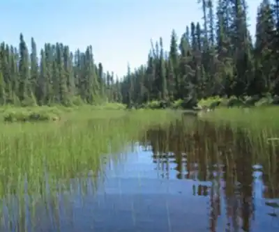
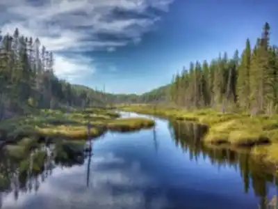
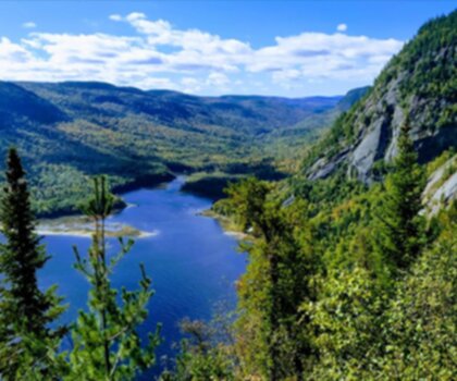
The park's topography tells a compelling story of ancient geological forces. Peaks rise dramatically from 300 to 900 meters above sea level, creating a rolling mountain landscape that feels surprisingly remote despite its accessibility. Deep valleys carve through the terrain, with the Sainte-Marguerite River canyon serving as one of the park's most striking features. This varied elevation creates distinct microclimates and ecosystems, making each trail feel like a journey through different worlds.
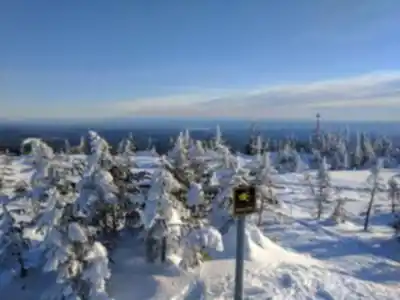
What sets Monts Valin apart from other Quebec parks is its year-round hiking opportunities. The extensive trail network allows visitors to experience the mountains in every season, from summer's lush green canopy to winter's snow-laden branches that create the famous "snow ghosts" formations. The trails range from easy family walks to demanding climbs that will test experienced hikers, with the park's challenging 50-kilometer trail system offering 600 meters of elevation gain for those ready to tackle the most demanding routes.
The Complete Trail Network
The park's comprehensive trail system represents one of Quebec's most diverse hiking experiences. The full network spans 50 kilometers of interconnected paths that wind through dense boreal forest, across exposed ridgelines, and along rushing mountain streams. With 600 meters of total elevation gain distributed across the various routes, hikers can customize their experience based on fitness level and available time.
The trail system's design allows for multiple approaches to exploring the park. Day hikers can tackle shorter segments that showcase specific features like waterfalls or viewpoints, while serious backpackers can commit to the full network for an immersive wilderness experience. The varied terrain means you'll encounter everything from gentle forest walks suitable for families to steep, technical climbs that demand proper equipment and experience.
Most hikers find the complete trail system requires a full day commitment, with estimated completion times around 13 hours and 30 minutes for strong hikers maintaining steady pace. This duration reflects not just the physical demands, but also the irresistible urge to pause frequently for photos and to simply absorb the changing landscapes.
Pic-de-la-Hutte: The Crown Jewel
The crown jewel of the park's trail system is the Pic-de-la-Hutte trail, which offers hikers two distinct experiences depending on their ambition and available time. This well-maintained trail system provides access to one of the park's highest peaks and most rewarding viewpoints.
The full version stretches approximately 16 kilometers round-trip with a substantial 670-meter elevation gain. This challenging route demands respect and preparation, recommended primarily for experienced hikers who can handle steep, sustained climbs and potentially changing weather conditions. The trail winds through dense boreal forest before emerging above the treeline, where the landscape opens up to reveal the full majesty of the Valin Mountains.
For those seeking a more manageable adventure, the abbreviated version covers just 3 kilometers with a gentle 70-meter elevation gain. This family-friendly option still delivers impressive views while remaining accessible to children and casual hikers. The shorter route provides an excellent introduction to the park's character without the physical demands of the full ascent.
The Summit Experience
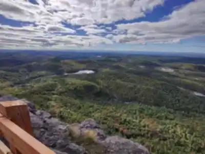
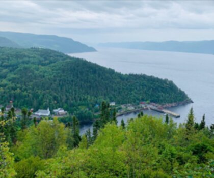
Regardless of which route you choose, both versions culminate at Pic-de-la-Hutte, standing proudly at 900 meters elevation. This summit represents one of the highest accessible points in the park and delivers panoramic views that justify every step of the climb. From this vantage point, hikers can survey the sprawling city of Saguenay spread along the river valley below, while the vast expanse of Lake Saint-Jean stretches to the horizon.
The summit experience changes dramatically with weather and season. Clear days offer visibility extending for dozens of kilometers, allowing hikers to appreciate the true scale of the Saguenay region's landscape. The interplay between the ancient mountains, the broad river valley, and the expansive lake creates a vista that captures the essence of Quebec's northern wilderness.
The exposed summit can be dramatically different from conditions in the forested valleys below. Wind speeds increase significantly, and temperatures drop noticeably even on warm days. Smart hikers pack extra layers regardless of valley conditions, as the summit's exposure to weather systems can create surprisingly challenging conditions.
Trail Access and Planning
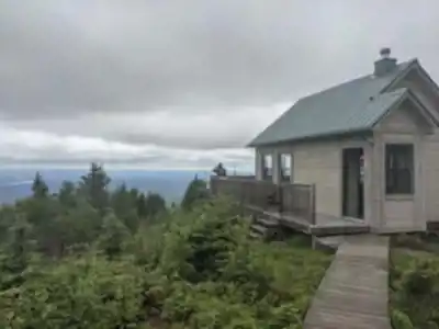
The Pic-de-la-Hutte trail system offers two convenient starting points, each serving different hiking strategies and preferences. The Discovery and Services Centre, located near the park's main reception area, provides the most comprehensive starting point. Here, hikers can gather current trail conditions, weather updates, and safety information before beginning their adventure. This location also offers the longest approach, adding distance but providing a more gradual introduction to the mountain environment.
Alternatively, the Pic-de-la-Hutte Parking area sits 9 kilometers from the Discovery and Services Centre, offering a more direct route to the trailhead. This option appeals to hikers who want to maximize their time on the actual mountain trails rather than the approach roads. The parking area provides adequate space for day hikers, though arriving early during peak season ensures the best spot selection.
The trail's design accommodates different skill levels through its two-variant system, but hikers should prepare appropriately regardless of their chosen route. The full version requires proper hiking boots, weather protection, and sufficient water and food for a full day adventure. Even the abbreviated version benefits from basic hiking preparation, as mountain weather can change quickly and terrain demands attention.
Seasonal Considerations
The May to October hiking window reflects the park's northern location and elevation. Early season hiking in May often encounters lingering snow patches and muddy conditions as the mountain sheds winter's accumulation. Summer months provide the most stable conditions, with July and August offering the warmest temperatures and most predictable weather patterns.
September and October reward hikers with spectacular fall colors as the boreal forest transforms into a tapestry of reds, oranges, and yellows. However, these months also bring increased weather variability and the possibility of early snow, making proper preparation even more critical.
The park's year-round accessibility means winter visitors can experience the mountains in their snow-covered glory, though this requires specialized equipment and winter hiking experience. The transformation from summer's green landscape to winter's dramatic snow formations creates an entirely different park experience that draws photographers and winter sports enthusiasts from across Quebec.
Services and amenities
This information may vary by season.
Recommended gear for this trail


Ready to go?
Everything you need to know before you goStarting Point
To access the hiking trails, you can start at the main trailhead located at the park's Discovery and Visitors Centre. The address is 360 Rang Saint-Louis, Saint-Fulgence, QC G0V 1S0. There are also several other trailheads within the park that can be accessed from different points along the park's road network. Make sure to check for specific directions to each trailhead based on your chosen route.
When?
Tuesday: 8:00 AM – 5:00 PM
Wednesday: 8:00 AM – 5:00 PM
Thursday: 8:00 AM – 5:00 PM
Friday: 8:00 AM – 5:00 PM
Saturday: 8:00 AM – 5:00 PM
Sunday: 8:00 AM – 5:00 PM
How much?
- Hiking shoes Essential
- → Salomon Elixir Tour Mid WP · 203.38 $
- Layered clothing Essential
- Rain jacket Essential
- Trekking poles
- → Black Diamond Trail Ergo Cork · 69.99 $
- Headlamp
- → Petzl Actik Core 625 · 103.95 $
FAQ - Frequently asked questions
Everything you need to knowTuesday: 8:00 AM – 5:00 PM
Wednesday: 8:00 AM – 5:00 PM
Thursday: 8:00 AM – 5:00 PM
Friday: 8:00 AM – 5:00 PM
Saturday: 8:00 AM – 5:00 PM
Sunday: 8:00 AM – 5:00 PM
The Essential Hiking Checklist
Everything you need for your next hike. Bilingual, printable, 1 page.
Download the free checklistAlternatives and suggestions
Similar hikes nearby
Discover other trails you might enjoy
Parc National Du Fjord-du-saguenay
Saguenay - Lac-Saint-Jean
Parc National De La Pointe-taillon
Saguenay - Lac-Saint-Jean
Sainte-rose-du-nord
Saguenay - Lac-Saint-Jean

Les Sentiers Du Saguenay
Saguenay - Lac-Saint-Jean

Parc De La Rivière Du Moulin
Saguenay - Lac-Saint-Jean

Parc des Chutes de Montauban
Saguenay - Lac-Saint-Jean
Hiking near Quebec City
40 trails to explore ~198 km away
We work hard to provide the most up-to-date and error-free data possible. If something seems incorrect, let us know! Your contribution helps the whole community.
Hikers' opinions