

Ready to explore Sentier Eucher? Here's everything you need to know before you go!
Discover the trail


Available trails
| Trails | Distance | Elevation | Duration | Difficulty | GPX |
|---|---|---|---|---|---|
| 12.84 km | 1550 m | 5h30 | GPX |
Trail description
Description
Sentier Eucher is an accessible hiking trail in the Saguenay - Lac-Saint-Jean region that delivers a solid forest experience with rewarding fjord views. Located near La Baie, this 4.5 km trail offers a moderate workout with 150 meters of elevation gain, making it a perfect choice when you want something more substantial than a casual walk but don't need a full-day commitment.
Trail character and terrain
The trail winds through dense mixed forest where towering conifers and hardwoods create a natural canopy overhead. You'll spend most of your time walking through these shaded woodland sections, where the forest floor is carpeted with fallen leaves and the occasional fallen log adds character to the landscape.
The terrain varies throughout the hike. Expect uneven footing in many places, with rocky sections that require attention, especially when wet. The trail surface ranges from packed earth to exposed roots and stone slabs. Nothing too technical, but you'll want to watch where you step rather than just cruising along on autopilot.
As you progress, the trail begins its gradual ascent toward the viewpoints. The climbs come in waves rather than one sustained push, giving you natural recovery spots between the steeper pitches. These uphill sections are where you'll feel the 150-meter elevation gain, but the grade stays manageable for most hikers.
The hiking experience
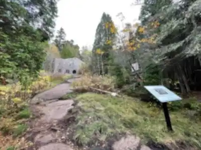
Starting from the trailhead, you'll immediately enter the forest atmosphere that defines much of this hike. The enclosed woodland creates a sense of quiet and focus, with filtered sunlight creating shifting patterns on the trail ahead. It's the kind of environment where you naturally fall into a steady rhythm.
The forest changes subtly as you climb. Drier ridges support different plant communities than the moister hollows, and you'll notice how the understory thickens or opens up depending on the canopy above. These small variations keep the walk interesting even when you're moving through similar-looking forest.
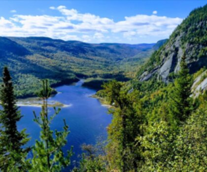
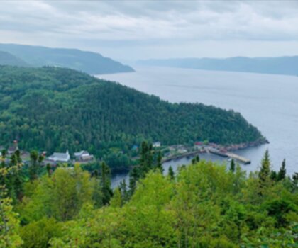
The real payoff comes at the scenic viewpoints overlooking the Saguenay Fjord. When the trees finally part and you get those panoramic views, the contrast with the enclosed forest makes the scenery feel even more dramatic. These overlooks are natural stopping points where most hikers take extended breaks to soak in the fjord landscape stretching out below.
Wildlife and natural features
The mixed forest habitat supports a variety of wildlife, and you'll have good chances for sightings if you move quietly and stay alert. Birds are the most common encounters—listen for calls echoing through the canopy and watch for movement in the branches above.
Squirrels are active throughout the forest, and you'll often hear them before you see them as they rustle through the leaf litter or chatter from the trees. Deer use this area regularly, and while sightings aren't guaranteed, they're common enough that it's worth moving quietly through the forest and scanning ahead on the trail.
The forest itself tells stories through its mix of tree species and ages. You'll pass through sections where mature trees dominate and others where younger growth fills in gaps from past disturbances. The vibrant flora changes with the seasons, from spring wildflowers to fall colors that make the fjord viewpoints even more spectacular.
Difficulty and pacing
With its "Easy" rating, Sentier Eucher works well for most fitness levels, though the rocky terrain and elevation gain mean it's more than a casual stroll. The 1.5-hour estimated time assumes a steady pace with brief stops, but many hikers take longer to fully enjoy the viewpoints and forest atmosphere.
The inclines are the main challenge, but they're spread throughout the hike rather than concentrated in one brutal climb. The rocky sections require attention but aren't technically difficult—just watch your footing and take your time when the trail gets uneven.
This trail hits a sweet spot for mixed groups. Newer hikers get a taste of "real" hiking with forest immersion and elevation gain, while experienced hikers can treat it as a shorter outing that still delivers satisfying views and natural variety.
Viewpoints and photography
The fjord overlooks are the undisputed highlights of this hike. These viewpoints offer expansive views over the Saguenay Fjord, with the dramatic landscape stretching toward the horizon. The contrast between the intimate forest experience and these wide-open vistas creates memorable moments that make the climb worthwhile.
Plan extra time at these spots. They're perfect for photos, snacks, and simply taking in the scenery. The viewpoints also serve as natural turnaround points where you can assess energy levels and weather before continuing or heading back.
Practical considerations
Footwear matters on this trail. Sturdy hiking boots provide the ankle support and grip you'll appreciate on the rocky sections and inclines. The uneven terrain can be tiring in inadequate shoes, and good boots make the whole experience more comfortable.
Bring plenty of water—more than you think you'll need for a 4.5 km hike. The elevation gain and time spent at viewpoints can leave you thirstier than expected. Pack some snacks too, especially something to enjoy at the fjord overlooks.
Weather preparation is important in this region. Conditions can change quickly, and the difference between shaded forest and exposed viewpoints means you might experience varying temperatures and wind conditions during a single hike. Layer appropriately and check the forecast before heading out.
Don't forget insect repellent during bug season, and bring sunscreen for the viewpoints where you'll be exposed to direct sunlight.
Trail etiquette and conservation
Sentier Eucher's well-maintained condition reflects both good management and responsible use by hikers. Help keep it that way by following Leave No Trace principles: pack out all trash, stay on designated trails, and avoid disturbing wildlife or vegetation.
When you encounter wildlife like deer, give them space and let them move away naturally. These brief encounters are special precisely because they happen on the animals' terms in their natural habitat.
The trail works best when hikers move at a sustainable pace and take breaks at logical spots like viewpoints. This approach lets you fully experience both the forest journey and the fjord destinations that make Sentier Eucher a standout option in the Saguenay - Lac-Saint-Jean region.
Recommended gear for this trail


Ready to go?
Everything you need to know before you goStarting Point
The trailheads for the hiking trails can be accessed from different locations. One primary starting point is located at 300 Rue de la Pointe-aux-Pins, La Baie, QC G7B 3N8. There is a parking lot available at this address for visitors.
When?
How much?
- Hiking shoes Essential
- → Salomon Elixir Tour Mid WP · 203.38 $
- Layered clothing Essential
- Rain jacket Essential
- Trekking poles
- → Black Diamond Trail Ergo Cork · 69.99 $
- Headlamp
- → Petzl Actik Core 625 · 103.95 $
FAQ - Frequently asked questions
Everything you need to knowThe Essential Hiking Checklist
Everything you need for your next hike. Bilingual, printable, 1 page.
Download the free checklistSimilar hikes nearby
Discover other trails you might enjoy
Parc National Du Fjord-du-saguenay
Saguenay - Lac-Saint-Jean
Parc National De La Pointe-taillon
Saguenay - Lac-Saint-Jean

Parc National Des Monts-valin
Saguenay - Lac-Saint-Jean
Sainte-rose-du-nord
Saguenay - Lac-Saint-Jean

Les Sentiers Du Saguenay
Saguenay - Lac-Saint-Jean

Parc De La Rivière Du Moulin
Saguenay - Lac-Saint-Jean
Hiking near Quebec City
40 trails to explore ~173 km away
We work hard to provide the most up-to-date and error-free data possible. If something seems incorrect, let us know! Your contribution helps the whole community.
Hikers' opinions