

Ready to explore Sentier pédestre du lac Kénogami? Here's everything you need to know before you go!
Discover the trail


Trail description
Description
The Sentier pédestre du lac Kénogami is a go-to hiking spot in the Saguenay - Lac-Saint-Jean region for anyone who wants a mix of quiet forest walking and lakefront scenery. Set in the broader landscape that makes this region such a draw for outdoor enthusiasts, the trail gives you that “away from it all” feeling without needing extreme terrain or technical skills to enjoy it.
What the trail is like
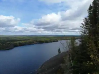
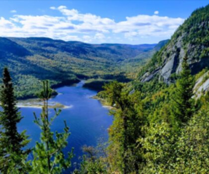
Hiking here is all about variety. The route moves through lush forests and follows sections along the serene shores of Lake Kénogami, so the scenery changes often enough to keep the walk interesting. You’ll spend time in dense woodland where the trail feels enclosed and quiet, then step out into more open areas that give you panoramic views of the lake. That shift between shaded forest and brighter viewpoints is one of the things that makes this trail system stand out.
The trails are described as well-maintained, which matters a lot in a place like this: it usually means you can focus on your footing and the views instead of constantly scanning for where the path goes next. Expect a natural, outdoorsy feel—forest underfoot, lakeside stretches with calmer ambience, and a general sense that you’re moving through a living landscape rather than a single “scenic lookout” destination.
Distance options and pacing
This is a trail system with multiple ways to hike it. The existing network spans approximately 45 kilometers, so there’s room to plan anything from a shorter outing to something that fills most of a day. If you’re looking for a specific, defined hike, there is also a 13 km option listed for the Sentier pédestre du lac Kénogami, with 400 m of elevation gain. That amount of climbing typically creates a more engaging hike than a flat shoreline stroll, but it can still be approachable if you take your time, pace your breaks, and keep your pack light.
Because there are options for both leisurely walks and more challenging hikes, it works well whether you’re a regular hiker looking for a longer route or someone newer who wants to choose a calmer segment. The best strategy is to think about how much time you want to spend moving versus stopping—this is a trail where pauses are part of the experience, especially when the lake views open up.
Landscapes you’ll actually notice on the hike
The forest sections are the kind where you can settle into a steady rhythm: consistent shade, a quieter soundscape, and the sense of being surrounded by nature. Then the trail breaks into open areas where the lake becomes the focus and the horizon widens. Those are natural places to slow down, take photos, or just enjoy the contrast after the woods.
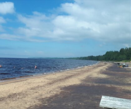
You’ll also come across peaceful spots that are well-suited for a picnic or a simple break. If you like to plan stops, bring snacks you can eat easily and take advantage of those calmer areas to rest your legs. If you’re hiking with others, these are also good regrouping points where everyone can catch up without feeling like they’re blocking the trail.
Navigation and trail marking
The trail is described as well-marked, which makes a big difference for planning. It means you can keep your attention on the scenery—forest details, shoreline views, and wildlife movement—rather than constantly worrying about missing a turn. Still, it’s worth keeping a steady awareness of where you are within the system, especially if you’re combining sections to build a longer day on the network.
Wildlife to watch for
This area is home to a range of wildlife, and part of the fun is simply staying alert as you move. You may spot deer along the edges of the woods or in quieter openings, and beavers are part of the local scene as well. Birdlife is another highlight, with numerous bird species in the area—especially noticeable when the forest is calm and you can hear calls before you see anything.
Wildlife sightings are never guaranteed, but it’s noted that it’s not uncommon to see animals going about their daily routines. If you want to increase your chances, keep your voice low in forest sections and pause occasionally in the quieter areas rather than walking straight through.
When to go
The best time to visit is during the warmer months, when the trails are most accessible and the region’s natural scenery is described as being in full bloom. Warmer-season hiking also makes lakeside sections more enjoyable, since you can comfortably stop for breaks and spend more time taking in the views without rushing.
Before you head out, it’s smart to check local weather conditions. Weather can shift quickly in many outdoor regions, and conditions near a large lake can feel different than what you expect from town—cooler breezes by the shore or changing cloud cover can affect comfort and visibility.
What to bring for a smooth day on the trail
Keep your packing simple and practical. The essentials mentioned for this hike are comfortable hiking shoes, plenty of water, and snacks. Shoes matter here because you’ll be transitioning between forest trail and more open lakeside areas, and a comfortable, supportive pair helps you keep a steady pace over the full distance you choose.
Water and snacks become even more important if you’re aiming for a longer outing within the 45 km system, or if you’re doing the 13 km route with its 400 m elevation gain. Plan to drink regularly rather than waiting until you feel thirsty, and pack snacks that you’ll actually want to eat mid-hike.
Making the most of the Saguenay - Lac-Saint-Jean setting
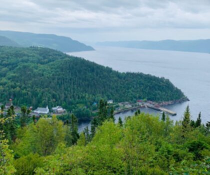
The Saguenay - Lac-Saint-Jean region is a big part of why this hike feels special. The trail sits within an area known for outdoor variety, so it’s easy to pair a hike here with other ways of spending time outside. After your hike on the Sentier pédestre du lac Kénogami, you can continue exploring the region through its charming local towns or by getting on the water with activities like kayaking and fishing. If you’re planning a longer stay, this trail can be one anchor activity among several—especially in the warmer months when both the trails and the lake-based options are at their most inviting.
Recommended gear for this trail


Ready to go?
Everything you need to know before you goStarting Point
The trailhead for the Lake Kenogami Walking Trail is located at the intersection of Route 172 and the Lake Kenogami Road, about 10 km southwest of Chicoutimi.
When?
How much?
- Hiking shoes Essential
- → Salomon Elixir Tour Mid WP · 203.38 $
- Layered clothing Essential
- Rain jacket Essential
- Trekking poles
- → Black Diamond Trail Ergo Cork · 69.99 $
- Headlamp
- → Petzl Actik Core 625 · 103.95 $
FAQ - Frequently asked questions
Everything you need to knowThe Essential Hiking Checklist
Everything you need for your next hike. Bilingual, printable, 1 page.
Download the free checklistSimilar hikes nearby
Discover other trails you might enjoy
Parc National Du Fjord-du-saguenay
Saguenay - Lac-Saint-Jean
Parc National De La Pointe-taillon
Saguenay - Lac-Saint-Jean

Parc National Des Monts-valin
Saguenay - Lac-Saint-Jean
Sainte-rose-du-nord
Saguenay - Lac-Saint-Jean

Les Sentiers Du Saguenay
Saguenay - Lac-Saint-Jean

Parc De La Rivière Du Moulin
Saguenay - Lac-Saint-Jean
Hiking near Quebec City
40 trails to explore ~163 km away
We work hard to provide the most up-to-date and error-free data possible. If something seems incorrect, let us know! Your contribution helps the whole community.
Hikers' opinions