Hiking Parcs Ruraux Rapide Danseur - panoramic view
--°C
Loading...
See forecast →

Hiking in Parcs Ruraux Rapide Danseur: trails, map and practical info

Abitibi-Témiscamingue • Quebec

4.5 Appreciated by 19 hikers
François Dumaine
By François DumaineContributor since 2016Updated 23/06/2026
Difficulty
Easy
Distance
6 km
Elevation
150 ft
Duration
2h00
Max altitude
150 ft
Dogs
Allowed

Escape into 6.3 km of forest and meadow in Abitibi-Témiscamingue's quieter corners. This easy 2-hour loop with 150 m elevation gain balances wooded trails with open vistas—perfect for spotting deer and native birds without the crowds.

Recommended for :
Beginners

Ready to explore Parcs Ruraux Rapide Danseur? Here's everything you need to know before you go!

Discover the trail

4 community photos

Available trails

Trails Distance Elevation Duration Difficulty GPX
4.5 km 0 m 1h Beginner
1.8 km 0 m 24min Beginner
Click a trail to see it on the map

Trail description

{
"remove_sentences": [
"deer have been spotted grazing in the open stretches",
"Birdlife is another consistent highlight.",
"The habitat variety here—closed canopy forest alongside open meadow—tends to support a wider range of species than you'd find in a single-ecosystem park. You'll often hear birds before you see them, so it's worth pausing in each section and listening."
],
"revision": "Replace the 'Wildlife and what to watch for' section with: '

Trail structure and park features

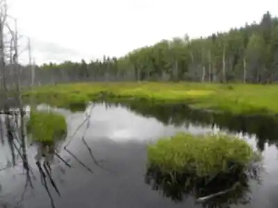
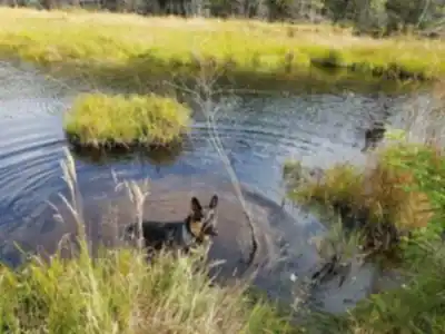
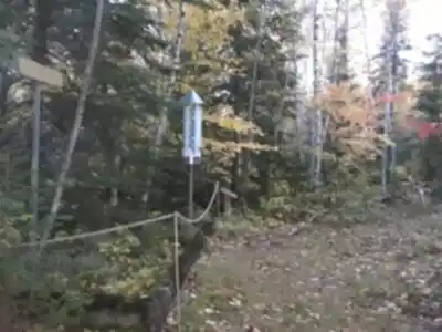
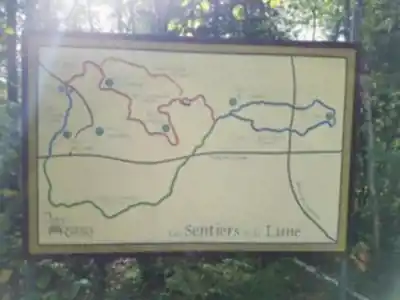
The parks are distributed along two distinct trail routes: La Promenade (1.8 km) and La Lune (4.5 km), for a combined experience of 6.3 km. Along these trails, ten parks are positioned at key points, each with a bench and informational display explaining the park's specific theme—whether historical, geological, landscape-focused, or natural phenomena related. This thematic structure encourages you to pause, read, and engage with the landscape more deeply than you might on a typical trail walk.

Each park is set up to convey a particular aspect of Rapide-Danseur and the surrounding region, making the walk as much about discovery and learning as it is about physical movement.'",
"remove_paragraph": "Parcs Ruraux Rapide-Danseur includes picnic areas, which makes it easy to build a longer, more relaxed day around the hike rather than treating it purely as a point-A-to-point-B walk. Walk a section of trail, find a spot to sit, eat lunch while you're still surrounded by forest and open landscape, then keep going. It's a setup that works especially well for families or groups where not everyone is there primarily for the hiking. Even if a full picnic isn't part of your plan, the park rewards a slower pace. The bird calls, the meadow views, and the general quiet are part of what the place offers—and those things are easier to appreciate when you're not rushing to get back to the car."
}

Services and amenities

Parking Icon Parking
Interpretation Center Icon Interpretation Center

This information may vary by season.

Recommended gear for this trail

LGPO Pick
Elixir Tour Mid WP
Salomon
Elixir Tour Mid WP
4.5 (2847 reviews)
Waterproof mid-height boot ideal for rocky terrain
203.38 $
See price
Daylite Plus 20L
Osprey
Daylite Plus 20L
4.7 (3215 reviews)
Lightweight and versatile for day hikes
109.99 $
See price
Most Popular
Wide Mouth 1L
Nalgene
Wide Mouth 1L
4.8 (12540 reviews)
Unbreakable and BPA-free — a hiking essential
23.11 $
See price
Best Value
Trail Ergo Cork
Black Diamond
Trail Ergo Cork
4.4 (1456 reviews)
Comfortable cork grip for long ascents
69.99 $
See price
Actik Core 625
Petzl
Actik Core 625
4.6 (1893 reviews)
USB rechargeable with 600 lumens for early starts
103.95 $
See price
Affiliate links — LGPO may earn a commission at no extra cost to you.

Ready to go?

Everything you need to know before you go

Where?

Address
Not available
GPS coordinates
46.3305183, -74.6718899
Phone
819 279-6124

Starting Point

To get to the Rapide Danseur Rural Parks trailhead, you must go to the municipality of Rapide-Danseur, located in the Abitibi-Témiscamingue region.

When?

Opening hours
From sunrise to sunset
Varies by season
Best season
Fall
Spectacular colors
Best time
Early morning
Less crowded
Weather (next days)
Loading

How much?

Entry fees
Adult
Free
Child
Free
What to bring?
Gear
Download the PDF checklist
Water & food
2L minimum
No water point on the trail
Bring energy snacks for a 4h+ hike
Good to know
Park rules
Dogs allowed
Safety
Download the GPX before you go
Limited cellular coverage on the trail
Slippery after rain
Be careful on rocky sections
In an emergency
Emergency
911
Parking GPS
46.3305183, -74.6718899
Center
819 279-6124

Hikers' opinions

4.5
8 Reviews
D
David
Nov 3, 2025
The 6.3-kilometer route is well-suited for beginners and families with children. Navigation could be improved with better signage, particularly on the return journey. The parking area is accessible, though note that parking fees apply. Despite minor directional challenges, the trail itself is enjoyable and the interpretation center adds educational value.
M
Marcus
Sep 12, 2025
This trail offers a refreshing outdoor experience with manageable terrain suitable for families. The interpretation center provides valuable insights into the local ecosystem, making it educational as well as recreational. While shade could be more abundant during summer months, the overall experience is rewarding and the peaceful atmosphere makes it an excellent escape from urban areas.
J
Jennifer
Jul 22, 2025
A pleasant hike that lived up to expectations for an easy-difficulty trail. The benches along the route provide convenient rest spots, and bringing snacks is recommended for a comfortable experience. The natural surroundings are beautiful, and the trail's accessibility makes it perfect for visitors of varying fitness levels.
S
Sophie
Apr 18, 2025
Visiting during spring was absolutely magical with wildflowers blooming throughout the trail. The 150-meter elevation gain provides just enough challenge to feel accomplishing without being overwhelming. The quiet environment and natural beauty create a perfect setting for reflection and relaxation away from city noise.
T
Thomas
Feb 14, 2025
This trail delivers a solid outdoor experience with diverse flora and fauna to observe. The interpretation center enhances understanding of the local environment. The two-hour estimated duration makes it ideal for a half-day outing, and the easy difficulty rating is accurate for most hikers seeking a leisurely walk through nature.

FAQ - Frequently asked questions

Everything you need to know
Easy
150.00 m
150.00 m
2h00
Yes
No
Yes
Yes
The Parcs Ruraux Rapide Danseur offers parking and an Interpretation Center for visitors. Check with the park for current hours and services before your visit.
The Parcs Ruraux Rapide Danseur trail takes approximately 2 hours to complete. This estimate is based on the 6.3 km distance and 150 m elevation gain on this easy-rated trail.
Didn't find your answer?
Free 1 pages

The Essential Hiking Checklist

Everything you need for your next hike. Bilingual, printable, 1 page.

Download the free checklist
Top 10 best hiking in Abitibi-Témiscamingue
Our ranking based on hiker reviews

Hiking near Laval

97 trails to explore ~110 km away

View trails
Did you spot an error?

We work hard to provide the most up-to-date and error-free data possible. If something seems incorrect, let us know!

Update : June 2026