

Ready to explore Tumbledown Mountain? Here's everything you need to know before you go!
Discover the trail
Trail description
Description
Tumbledown Mountain stands as one of western Maine's most rewarding hiking destinations, offering a perfect blend of challenging terrain and spectacular alpine scenery. This 9-kilometer adventure delivers an authentic backcountry experience that feels surprisingly remote despite its accessibility, making it a standout peak in Maine's mountainous landscape.
The Trail Experience
The Loop Trail provides the mountain's signature hiking experience, demanding respect and solid preparation from anyone who tackles its challenging terrain. With 518 meters of elevation gain spread across the 9-kilometer route, you're looking at roughly 4.5 hours of sustained effort that tests your endurance while delivering consistent rewards along the way.
The ascent begins in dense, lush forests where towering trees create a natural cathedral overhead. Sunlight filters through the canopy in dappled patterns, illuminating the rich forest floor beneath your feet. The well-defined trail winds steadily upward through this lower section, allowing you to settle into a rhythm while your legs warm up for the more demanding terrain ahead.
As you climb higher, the character of the hike transforms dramatically. The protective forest canopy gradually opens up, revealing increasingly rocky terrain that becomes the mountain's defining feature. Granite slabs and boulder fields emerge as prominent obstacles and opportunities, creating natural staircases that require both physical effort and mental engagement. These rocky sections add genuine excitement to the climb without crossing into technical territory that would require specialized equipment.
The trail's hard difficulty rating reflects not just the sustained elevation gain, but the varied demands this terrain places on hikers. While the path remains generally well-marked throughout, the rocky upper sections require constant attention to foot placement and route-finding. You'll find yourself reading the landscape, choosing your steps carefully, and occasionally using your hands for balance as you navigate the granite obstacles.
Summit Rewards
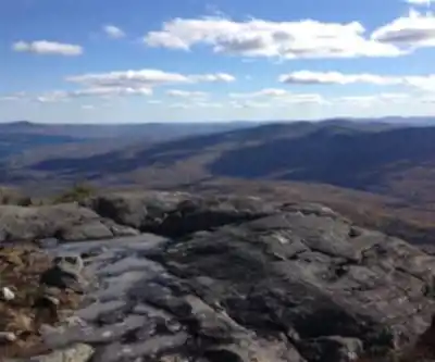
Reaching Tumbledown Mountain's summit delivers one of western Maine's most spectacular panoramic experiences. The 360-degree views stretch endlessly across rolling mountains and pristine lakes, creating a landscape that perfectly captures the wild character of Maine's backcountry. On clear days, the vista extends all the way to Mount Washington in New Hampshire, providing a dramatic backdrop that emphasizes the impressive scale of New England's mountain country.
The summit's crown jewel is undoubtedly Tumbledown Pond, a pristine alpine tarn that seems almost impossibly placed at this elevation. This crystal-clear body of water offers brave souls a refreshing swimming opportunity, though the water temperature remains shockingly cold even during summer months. Whether you take the plunge or not, the pond creates an ideal setting for extended breaks, lunch, and photography. Its mirror-like surface reflects surrounding peaks and sky, creating picture-perfect moments that justify every step of the challenging climb.
The open granite slabs surrounding the summit provide multiple comfortable vantage points for taking in the scenery. These rocky platforms warm quickly in direct sunlight, making them perfect spots for extended rest breaks where you can fully appreciate both your accomplishment and the stunning natural beauty spread out below.
Wildlife and Natural Environment
Tumbledown Mountain showcases the incredible biodiversity of Maine's mountain ecosystems through its varied elevation zones and habitat types. The diverse terrain supports an impressive range of wildlife that can turn any hike into an unexpected adventure. Moose sightings remain possible throughout the area, particularly during early morning or evening hours when these massive animals move through forest corridors and clearings. White-tailed deer appear more frequently, often spotted bounding through the trees with their characteristic white tail flags raised in alarm.
The mountain's plant communities change dramatically with both elevation and season, creating distinctly different hiking experiences throughout the year. Spring and summer months bring vibrant wildflower displays that add splashes of color to the landscape. The forest understory comes alive with blooming species that thrive in filtered sunlight, while higher elevations support hardy alpine plants specially adapted to harsh conditions near the summit.
The transition from dense forest to exposed rock creates distinct ecological zones, each supporting different plant communities. Lower elevations feature typical northern hardwood and mixed forest species, while the rocky upper reaches host specialized vegetation that can handle the exposure, temperature extremes, and thinner soils found at higher elevations.
Planning and Preparation
Success on Tumbledown Mountain starts with realistic expectations and thorough preparation. The 4.5-hour timeframe assumes good weather conditions and reasonable fitness levels, but rocky terrain can significantly slow progress, especially during descent when careful foot placement becomes even more critical for safety.
Trail conditions vary dramatically with weather and season, making current condition checks essential before heading out. Weather forecasts become particularly important given the mountain's significant exposure at higher elevations, where conditions can change rapidly and differ markedly from valley weather patterns.
Essential gear includes plenty of water, as the combination of rocky terrain and sustained elevation gain creates substantial fluid needs. Energy-rich snacks help maintain stamina throughout the demanding climb, while proper footwear with excellent traction becomes absolutely crucial for safely navigating the extensive rocky sections. The varied terrain and potential for rapidly changing weather make layered clothing systems particularly valuable for maintaining comfort and safety.
Leave No Trace principles take on special importance in this pristine mountain environment. The alpine pond and summit ecosystem are particularly fragile and require careful attention to minimize human impact. Pack out all trash, stay on established trails where they exist, and exercise special care around the pond area where vegetation and soil damage easily.
Tumbledown Mountain delivers an authentic Maine mountain experience that successfully combines significant physical challenge with outstanding natural beauty. The constantly varied terrain keeps the hike engaging from start to finish while building toward the spectacular summit payoff, making this a destination that satisfies both adventure seekers and those looking to connect deeply with Maine's wild mountain landscape.
Recommended gear for this trail


Ready to go?
Everything you need to know before you goStarting Point
The start of the trails at the tumbledown mountain can be accessed from the parking lot on the south side of the mountain.
When?
How much?
- Hiking shoes Essential
- → Salomon Elixir Tour Mid WP · 203.38 $
- Layered clothing Essential
- Rain jacket Essential
- Trekking poles
- → Black Diamond Trail Ergo Cork · 69.99 $
- Headlamp
- → Petzl Actik Core 625 · 103.95 $
FAQ - Frequently asked questions
Everything you need to knowThe Essential Hiking Checklist
Everything you need for your next hike. Bilingual, printable, 1 page.
Download the free checklistSimilar hikes nearby
Discover other trails you might enjoy

Long Mountain
Western Mountains
Pleasant Mountain
Western Mountains
Witt's End Trail
Western Mountains
Bear Mountain Inn + Barn Maine
Western Mountains
Bald Pate Mountain
Western Mountains
Screw Auger Falls
Western Mountains
Hiking near North Conway
0 trails to explore ~90 km away
We work hard to provide the most up-to-date and error-free data possible. If something seems incorrect, let us know! Your contribution helps the whole community.
Hikers' opinions