

Ready to explore Crater Lake? Here's everything you need to know before you go!
Discover the trail
Trail description
Description
Crater Lake is one of those spots in the New Jersey Highlands that quietly earns its reputation. Tucked within the Skylands Region, this circular lake sits at the heart of a trail system that draws hikers looking for a solid half-day outing with real terrain underfoot. At 19 km with 300 m of elevation gain and an estimated time of around 5 hours 15 minutes, it sits comfortably in the moderate category — challenging enough to feel rewarding, accessible enough that you don't need to be a seasoned mountaineer to enjoy it.
The Landscape
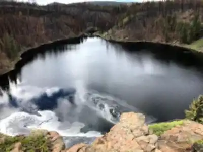
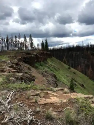
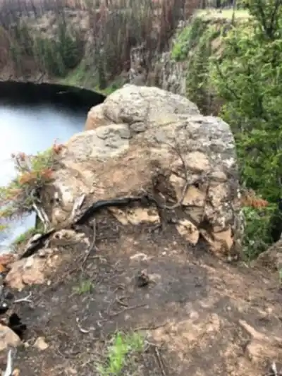
The lake itself is the centerpiece — a circular, water-filled depression roughly 1,000 feet in diameter and about 100 feet deep, carved into the New Jersey Highlands geology. It's a striking feature in a region that doesn't always get the credit it deserves for dramatic natural scenery. The surrounding terrain is classic Highlands: rocky ridgelines, mixed hardwood and conifer forest, and the kind of quiet that reminds you how close you can get to genuine wilderness without leaving the state.
The trails around Crater Lake wind through this landscape in a way that gives you multiple perspectives on the water and the surrounding hills. You're not just circling a lake — you're moving through varied terrain that shifts between open rocky sections with views and denser forested stretches where the canopy closes in overhead.
The Hike
With 19 km on the ground and 300 m of cumulative elevation gain, this is a route that asks something of you without being punishing. The moderate rating is accurate — expect some steady climbing, a few rockier sections that require attention underfoot, and enough distance that pacing yourself matters. The 5-hour-15-minute estimate is a reasonable benchmark for hikers moving at a comfortable pace with stops for water and a look around.
The elevation changes are spread out rather than concentrated in one brutal climb, which makes the overall experience feel manageable. You'll gain and lose height progressively as the trail follows the natural contours of the Highlands terrain. That said, the rocky sections can slow you down, especially if conditions are wet, so factor that in when you're planning your day.
What Makes This Trail Stand Out
In a region full of solid hiking options, Crater Lake earns its place on the list for a few specific reasons. The lake itself is genuinely unusual — a near-perfect circular depression filled with groundwater, sitting quietly in the middle of the Highlands forest. It's the kind of geological feature that makes you stop and actually think about what you're looking at rather than just walking past.
The combination of lake views, ridge terrain, and forest cover gives the route variety that keeps the distance from feeling repetitive. You're not grinding out kilometers on a flat path — the trail moves, the scenery shifts, and there are enough natural landmarks along the way to give the hike a sense of progression.
For hikers based in or visiting the Skylands Region, this is also a route that holds up well as a standalone day out. The distance and elevation are substantial enough that you arrive back at the trailhead feeling like you actually did something, without needing to string together multiple trails or plan a complex itinerary.
Practical Information
- Distance: 19 km
- Elevation gain: 300 m
- Difficulty: Moderate
- Estimated time: 5 hours 15 minutes
- Region: Skylands Region, New Jersey
Start early if you're planning to do the full route, especially on warmer days. The Skylands Region can get busy on weekends, and an early start gives you the trail largely to yourself for the first couple of hours. Bring enough water for the full distance — there are no guarantees of reliable water sources along the way, and 19 km is enough ground that running short is a real inconvenience.
Footwear matters here. The rocky Highlands terrain rewards a boot with decent ankle support and grip. Trail runners can work for experienced hikers comfortable on uneven ground, but this isn't a route where road shoes are going to serve you well, particularly on the rockier sections or after rain.
Getting There
Crater Lake is located in the Skylands Region of New Jersey. Check current trailhead access and parking details before heading out, as conditions and access points can vary by season. The New Jersey Highlands are well-served by a network of marked trails, and Crater Lake connects into that broader system, so it's worth reviewing a current trail map before you go to confirm your planned route and any relevant access information.
The Skylands Region is one of New Jersey's most rewarding areas for hiking, and Crater Lake is a strong example of what makes it worth the trip — genuine terrain, a distinctive natural feature, and enough distance to make a proper day of it.
Recommended gear for this trail


Ready to go?
Everything you need to know before you goStarting Point
The crater lake trails start at the parking lot on the east side of the lake.
The trails at the crater lake in New Jersey can be accessed from the parking lot off of Pleasant Valley Road.
When?
How much?
- Hiking shoes Essential
- → Salomon Elixir Tour Mid WP · 203.38 $
- Layered clothing Essential
- Rain jacket Essential
- Trekking poles
- → Black Diamond Trail Ergo Cork · 69.99 $
- Headlamp
- → Petzl Actik Core 625 · 103.95 $
FAQ - Frequently asked questions
Everything you need to knowThe Essential Hiking Checklist
Everything you need for your next hike. Bilingual, printable, 1 page.
Download the free checklistSimilar hikes nearby
Discover other trails you might enjoy

Lake Sonoma
Skylands Region
Blue Mountain Lakes
Skylands Region
Sunrise Mountain Overlook
Skylands Region
Scarlet Oak Pond Walk
Skylands Region
Stairway To Heaven Trail
Skylands Region
Culver lake
Skylands Region
Hiking near Newark
0 trails to explore ~73 km away
We work hard to provide the most up-to-date and error-free data possible. If something seems incorrect, let us know! Your contribution helps the whole community.
Hikers' opinions