


Ready to explore Dater Mountain Nature Park? Here's everything you need to know before you go!
Discover the trail
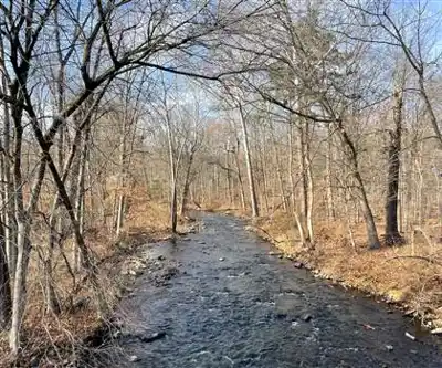
Trail description
Dater Mountain Nature Park sits quietly in New York's Hudson Valley, offering 350 acres of forested terrain that feels surprisingly remote despite its proximity to major population centers. This park delivers the kind of hiking experience that draws people back repeatedly—well-maintained trails through diverse ecosystems, genuine wildlife encounters, and rewarding views that make the climbs worthwhile.
The park's location within the New York/New Jersey Highlands gives it a distinctive character. You're hiking through ancient geological formations that create varied terrain, from gentle woodland paths to steeper ascents that test your legs. The elevation gain ranges from 140-150 meters depending on your chosen route. The popular main loop (2.4 miles/3.86 km) takes approximately 1-1.5 hours, while the full Kakiat Trail route (4.75 miles/7.65 km) takes 3+ hours and offers 600+ feet of elevation gain for a more substantial hiking experience.
Trail System and Terrain
The park features multiple trail options including the Orange Trail, Blue Trail, Kakiat Trail, and White Bar Trail, each marked with distinctive colored blazes. The popular main loop combines the Orange Trail (steep initial climb) with the Blue Trail (more level route to Sleater Hill overlook). This well-marked path takes you through different forest communities as you gain elevation, starting in mixed hardwood areas and transitioning into more specialized highland ecosystems. The trail surface varies from packed earth to occasional rocky sections, requiring standard hiking boots but nothing technical.
What makes these trails particularly appealing is how they reveal the landscape gradually. You'll start among towering trees that create a cathedral-like atmosphere, with filtered sunlight creating constantly changing patterns on the forest floor. As you climb, the canopy opens up periodically, offering glimpses of what's to come at the higher elevations.
The park's trail system accommodates different experience levels effectively. Newcomers to hiking will find the paths challenging enough to feel accomplished without being overwhelming, while experienced hikers appreciate the opportunity for a solid workout without committing to an all-day adventure. The trails are consistently well-maintained, with clear blazing and minimal obstacles.
Views and Scenic Highlights
The payoff for your climbing effort comes at the higher elevations, where the forest opens up to reveal panoramic views of the Ramapo Mountains. Key viewpoints include Sleater Hill overlook on the main loop. These vistas stretch across multiple ridgelines, giving you a sense of the broader Highland region's scale and beauty. The viewpoints are positioned naturally along the trail system, so you don't need to make difficult detours to reach them.
From the elevated positions within the park, you can see how the preserved lands connect across the region, creating wildlife corridors and maintaining the area's ecological integrity.
The scenic overlooks serve as natural rest stops where you can appreciate both the immediate landscape and the broader conservation efforts that make places like this possible. These spots are ideal for photography, particularly during the golden hours of early morning or late afternoon when the light enhances the mountain contours.
Wildlife and Natural Features
Dater Mountain Nature Park supports wildlife populations that reflect the Hudson Valley's biodiversity. The timber rattlesnake, while elusive, represents one of the area's most significant conservation success stories. These snakes are rarely encountered but indicate the park's healthy ecosystem. The Allegheny woodrat, another rare species, finds suitable habitat in the park's rocky areas and forest edges.
Birdwatchers should bring binoculars to fully appreciate the variety of species that inhabit different elevations and forest types within the park. The diverse habitats support both resident and migratory birds, with seasonal variations that make repeat visits worthwhile. Spring and fall migrations can be particularly productive for birding.
The seasonal wildflower displays add visual interest throughout the growing season. Spring brings early bloomers that take advantage of sunlight filtering through bare branches, while summer flowers provide color in forest openings and along trail edges. These floral displays change throughout the season, creating different experiences during multiple visits.
Seasonal Considerations and Planning
The park operates from dawn to dusk year-round, with each season offering distinct advantages. Spring hiking reveals the forest awakening, with wildflowers emerging and bird activity increasing. Summer provides full canopy cover that keeps trails cooler, though you'll want to start early on hot days. Fall delivers spectacular foliage displays that make the elevated viewpoints particularly rewarding.
Winter hiking is possible but requires appropriate preparation for potentially icy conditions. The bare trees during winter months actually enhance some views by removing visual barriers, though you'll need to dress appropriately for temperature changes as you gain elevation.
Weather conditions can change quickly in the Hudson Valley, particularly at higher elevations. Check current conditions before heading out, and pack layers even for seemingly stable weather. The forest provides some protection from wind, but exposed viewpoints can be significantly cooler and breezier than sheltered trail sections.
Access and Practical Information
The park's location near the New York State Thruway makes it accessible for visitors from Rockland County and Orange County, as well as those traveling from New York City or northern New Jersey. This accessibility, combined with the park's manageable size, makes it an excellent choice for both planned hiking trips and spontaneous outdoor adventures.
Essential items for your visit include water, snacks, and appropriate footwear. While the trails aren't technically demanding, proper hiking boots provide better traction and ankle support on uneven terrain. Bring more water than you think you'll need, especially during warmer months when the climbing sections will increase your fluid requirements.
The park represents part of a larger open space acquisition program focused on preserving the New York/New Jersey Highlands. This conservation context adds meaning to your visit—you're experiencing landscapes that have been specifically protected for their ecological and recreational value. The park provides a peaceful retreat from urban environments while supporting important wildlife habitat and watershed protection.
Recommended gear for this trail


Ready to go?
Everything you need to know before you goStarting Point
The trails at the dater mountain nature park in New York can be accessed from the parking lot on Dater Mountain Road.
When?
How much?
- Hiking shoes Essential
- → Salomon Elixir Tour Mid WP · 203.38 $
- Layered clothing Essential
- Rain jacket Essential
- Trekking poles
- → Black Diamond Trail Ergo Cork · 69.99 $
- Headlamp
- → Petzl Actik Core 625 · 103.95 $
FAQ - Frequently asked questions
Everything you need to know
25 hikes under 2 hours from Montreal
Distance, elevation, parking and season for each one. The ones we go back to ourselves.
Get the guideSimilar hikes nearby
Discover other trails you might enjoy
West Mountain
Hudson Valley

Witches Hole
Hudson Valley
Appalachian Trail
Hudson Valley
Little Dam Lake
Hudson Valley
Raven's Rock
Hudson Valley
Sterling Forest Fire Tower
Hudson Valley
Hiking near Newark
0 trails to explore ~49 km away
We work hard to provide the most up-to-date and error-free data possible. If something seems incorrect, let us know! Your contribution helps the whole community.
Hikers' opinions
Be the first to review!
No hiker has shared their experience yet. Share your impressions and help other hikers!