

Ready to explore Mount Robson? Here's everything you need to know before you go!
Discover the trail
Trail description
Description
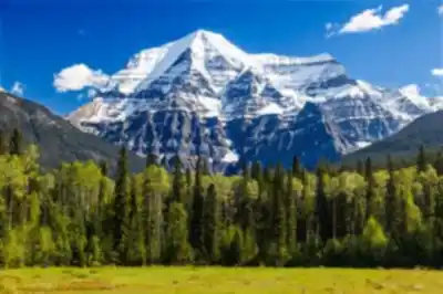
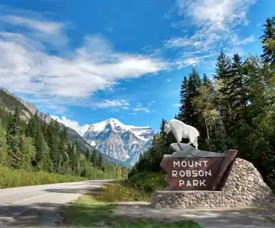
Mount Robson is the highest peak in the Canadian Rockies, topping out at 3,954 metres (12,972 feet). It sits at the heart of Mount Robson Provincial Park in Northern British Columbia, right along the Yellowhead Highway (Highway 16), and its south face rises so abruptly from the valley floor that it stops traffic — literally. For anyone driving through, it's one of those landmarks that demands you pull over.
The primary hiking destination is the Berg Lake Trail, which clocks in at 22-23 kilometres one way with approximately 800 metres of elevation gain, rated Moderate to Strenuous. This scenic route follows the Robson River past waterfalls and lookouts to reach Berg Lake and the base of Mount Robson. Most hikers complete this as a multi-day backcountry trip, though fit day-hikers can complete it in a single long day. The trail requires solid fitness and preparation, but does not require technical mountaineering skills.
Mount Robson Provincial Park is located in northern BC, approximately 4 hours north of Kamloops or 1 hour east of Jasper, AB, making it accessible to the broader Rocky Mountain hiking community.
The Terrain
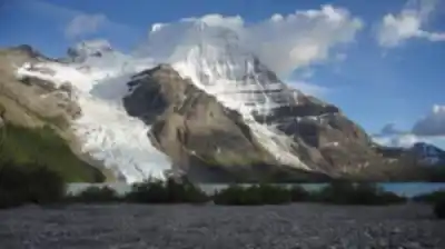
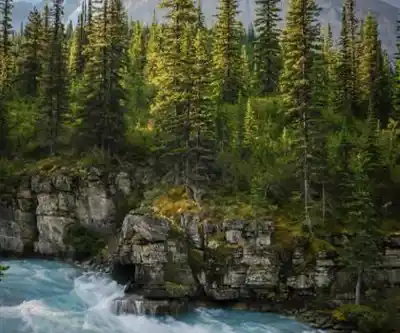
The approach trails wind through distinct ecological zones — valley-bottom forests give way to subalpine meadows and alpine tundra. The Berg Lake itself sits in a glaciated basin, surrounded by the raw rock and ice of the upper mountain. The scale of the place only becomes clear once you're moving through it. What looks like a manageable slope from the highway turns into something far more demanding once you're on the ground.
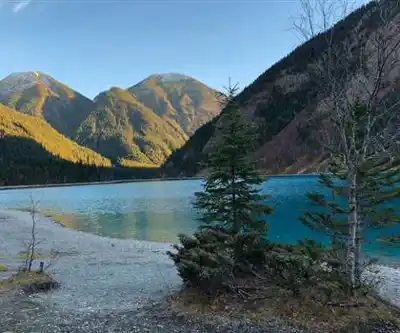
The glacier-fed lake reflects Mount Robson's north face, creating one of the most iconic mountain vistas in Canada. The glacier itself is accessible from the lake for those with appropriate experience, but the hiking trail itself remains non-technical.
Technical Climbing vs. Hiking
It is important to distinguish between the popular hiking route to Berg Lake and the technical mountaineering routes that approach the summit. The North Face route is considered one of the most technically demanding climbing routes in North America, attracting experienced mountaineers from around the world. Summit success rates on Mount Robson are notably low compared to other major peaks in the Canadian Rockies — the mountain earns its reputation. The Berg Lake Trail approach does not attempt the summit and does not require glacier travel or mountaineering skills.
Weather and Conditions
Mount Robson has a well-documented habit of making its own weather. The summit is frequently hidden in cloud, and conditions can shift from clear to whiteout in a matter of hours. The mountain's unofficial name — Cloud Cap Mountain — wasn't given lightly. Anyone planning a trip here needs to build flexibility into their schedule and come prepared for cold, wet, and windy conditions at any point during the season.
This unpredictability is part of what makes Mount Robson so demanding. Sound judgment about weather windows and realistic assessment of conditions matter significantly.
Cultural and Historical Context
The Texqakallt, a Secwepemc people and the area's earliest inhabitants, know this peak as Yuh-hai-has-kun — "The Mountain of the Spiral Road." That name reflects a relationship with this landscape that goes back far longer than any recorded mountaineering history.
The European name likely honours Colin Robertson, who worked for both the North West Company and the Hudson's Bay Company in the early 19th century, though the mountain was long assumed to commemorate John Robson, an early premier of British Columbia. The first recorded summit was reached in 1913 by a group from the American Alpine Club, establishing Mount Robson's place in North American mountaineering history from the start.
The Park Setting
Mount Robson Provincial Park protects the entire mountain and the surrounding landscape. The trail network lets hikers experience the mountain's scale without requiring technical mountaineering skills. These trails pass through diverse ecosystems and deliver changing perspectives on the peak and the broader range as you move through them.
Backcountry camping within the park makes multi-day trips possible, which is the practical reality for anyone tackling the full Berg Lake route. The park also has lakes and streams that support fishing, and the backcountry in winter opens up possibilities for those with the skills and equipment to handle those conditions.
Who This Route Is For
With approximately 800 metres of elevation gain over 22-23 kilometres, this route demands good physical fitness and solid backcountry experience. Proper equipment, navigation skills, and familiarity with alpine weather are essential. If you're newer to mountain travel, the park's shorter trails offer a legitimate and rewarding way to experience Mount Robson's environment. For those seeking to summit Mount Robson itself, glacier travel skills and technical mountaineering experience are baseline requirements.
For those ready for the Berg Lake hike, Mount Robson delivers one of Canada's most iconic mountain experiences.
Recommended gear for this trail


Ready to go?
Everything you need to know before you goStarting Point
The mount robson is located in British Columbia. To get to the start of the trails, take Highway 16 east from Jasper to the town of Valemount. From there, take the mount robson Parkway (Highway 5) north to the park entrance.
When?
How much?
- Hiking shoes Essential
- → Salomon Elixir Tour Mid WP · 203.38 $
- Layered clothing Essential
- Rain jacket Essential
- Trekking poles
- → Black Diamond Trail Ergo Cork · 69.99 $
- Headlamp
- → Petzl Actik Core 625 · 103.95 $
FAQ - Frequently asked questions
Everything you need to knowThe Essential Hiking Checklist
Everything you need for your next hike. Bilingual, printable, 1 page.
Download the free checklistSimilar hikes nearby
Discover other trails you might enjoy

Kinney Lake
Northern British Columbia

Liard Hot Springs Lodge
Northern British Columbia
Boya Lake
Northern British Columbia
Kinuseo Falls
Northern British Columbia
Hudson Bay Mountain
Northern British Columbia
Stone Mountain Provincial Park
Northern British Columbia
Hiking near Jasper
82 trails to explore ~77 km away
We work hard to provide the most up-to-date and error-free data possible. If something seems incorrect, let us know! Your contribution helps the whole community.
Hikers' opinions