

Ready to explore Monashee Mountains? Here's everything you need to know before you go!
Discover the trail
Oh no! We don't have any photos 😢
This trail hasn't been captured yet. Be the first to share your adventure!Trail description
Description
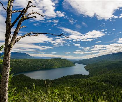
The Monashee Mountains sprawl across 530 kilometers of British Columbia's interior, creating one of the province's most diverse and accessible mountain ranges for hikers. Located in the Thompson Okanagan region, these mountains bridge the gap between the wet coastal ranges and the dry interior plateaus, resulting in a unique landscape that shifts dramatically as you gain elevation.
The name "Monashee" comes from a Gaelic word meaning "mountains of peace," and the range lives up to this description with its relatively uncrowded trails and serene wilderness settings. Unlike the heavily trafficked peaks closer to Vancouver, the Monashees offer a sense of solitude that's increasingly rare in British Columbia's outdoor recreation areas.
Trail Variety and Terrain
The range accommodates hikers of all experience levels, from gentle valley walks through old-growth forests to demanding alpine ascents that require scrambling skills. The lower elevations feature dense stands of cedar, hemlock, and Douglas fir, while the montane zone transitions into Engelmann spruce and subalpine fir. Above treeline, hikers encounter expansive alpine meadows that burst with wildflowers during the brief summer growing season.
The Pinnacles Trail represents the moderate hiking experience that draws many visitors to the Monashees. This trail begins in thick forest cover where the canopy filters sunlight into dappled patterns on the forest floor. As you climb, the trees gradually thin, revealing glimpses of the jagged granite spires that give the trail its name. The final approach opens onto viewpoints where the full drama of the surrounding peaks and valleys unfolds below.
For experienced hikers seeking a serious challenge, the Mount Begbie Trail delivers a strenuous workout with significant elevation gain. This demanding route tests your endurance and navigation skills, particularly in the upper sections where the trail becomes less defined. The summit rewards your effort with panoramic vistas that stretch across multiple mountain ranges and valley systems.
What Makes the Monashees Special
The interior location of the Monashees creates a hiking experience distinct from other British Columbia ranges. The drier climate means more stable weather patterns and longer periods of clear skies, making them ideal for multi-day adventures. The granite geology produces dramatic cliff faces and distinctive rock formations that provide natural landmarks for navigation and stunning photographic opportunities.
Water features throughout the range add another dimension to the hiking experience. Cascading waterfalls tumble down rocky faces during snowmelt season, while hidden alpine tarns provide perfect rest stops on longer climbs. The sound of running water is a constant companion on many trails, creating a peaceful soundtrack that enhances the "mountains of peace" atmosphere.
Wildlife and Natural Features
The Monashees support a healthy population of large mammals that hikers may encounter, particularly during early morning or evening hours. Black bears are common throughout the range and require proper food storage and awareness. Moose frequent the wetland areas and lake shores, while mountain goats inhabit the higher rocky terrain and cliff faces.
Birdlife is abundant and varied across the elevation zones. Golden eagles and red-tailed hawks patrol the alpine areas, while the forests ring with the calls of varied thrushes, winter wrens, and numerous warbler species. The crystal-clear lakes scattered throughout the range provide habitat for waterfowl and serve as scenic destinations for day hikes or overnight camping trips.
These lakes, formed by glacial action and fed by snowmelt and springs, maintain remarkably clear water that reflects the surrounding peaks. Many remain partially frozen well into summer at higher elevations, creating striking contrasts between ice, water, and the surrounding alpine vegetation.
Seasonal Considerations and Activities
The hiking season in the Monashees typically runs from late June through September, though lower elevation trails may be accessible earlier and later in the year. Snow can persist at higher elevations well into July, and early season hikers should be prepared for potentially challenging conditions including stream crossings swollen with snowmelt.
Summer brings warm, dry conditions that make for comfortable hiking, but also increases fire risk in the surrounding forests. Check current fire restrictions before heading out, as campfires and smoking may be prohibited during high-risk periods. The dry conditions also mean dust on popular trails, so consider bringing a bandana or buff for protection.
Beyond hiking, the range offers excellent opportunities for camping, both at established sites and in backcountry locations. The fishing in mountain lakes and streams can be productive for those with proper licenses, particularly for native trout species. Winter transforms the Monashees into backcountry skiing terrain, though this requires advanced skills and avalanche safety knowledge.
Planning Your Visit
The pristine environment of the Monashees depends on visitors following Leave No Trace principles. Pack out all waste, stay on designated trails to prevent erosion and vegetation damage, and camp only in appropriate locations. Weather conditions can change rapidly in mountain environments, so carry appropriate layers, rain gear, and emergency supplies even on day hikes.
Water sources are generally abundant, but purification is recommended. Many trails cross streams multiple times, and proper footwear with good traction becomes essential, especially during wet conditions or early season when snow patches may create slippery surfaces.
The region's location in the interior of British Columbia means that weather patterns can be quite different from coastal areas. Summer days are often warm and sunny, but temperatures drop significantly at night and at higher elevations. Afternoon thunderstorms are possible, particularly during late summer, making early starts advisable for longer hikes.
Access to many trailheads requires driving on forest service roads that may not be suitable for all vehicles. Check current road conditions and ensure your vehicle is appropriate for potentially rough, unpaved surfaces. Some areas may require high clearance or four-wheel drive capabilities, and it's wise to carry basic recovery gear like a shovel and tow strap when venturing onto these backcountry access routes.
Recommended gear for this trail


Ready to go?
Everything you need to know before you goStarting Point
The monashee mountains are located in the interior of British Columbia, Canada. The closest town is Revelstoke, which is about a two-hour drive from the mountain range.
When?
How much?
- Hiking shoes Essential
- → Salomon Elixir Tour Mid WP · 203.38 $
- Layered clothing Essential
- Rain jacket Essential
- Trekking poles
- → Black Diamond Trail Ergo Cork · 69.99 $
- Headlamp
- → Petzl Actik Core 625 · 103.95 $
FAQ - Frequently asked questions
Everything you need to knowThe Essential Hiking Checklist
Everything you need for your next hike. Bilingual, printable, 1 page.
Download the free checklistSimilar hikes nearby
Discover other trails you might enjoy

Big White Ski Resort
Thompson Okanagan

Cougar Canyon
Thompson Okanagan
Spectrum Lake
Thompson Okanagan
Clearwater Lake
Thompson Okanagan
Mahood Lake
Thompson Okanagan
Kentucky Lake
Thompson Okanagan
Hiking near Jasper
82 trails to explore ~80 km away
We work hard to provide the most up-to-date and error-free data possible. If something seems incorrect, let us know! Your contribution helps the whole community.
Hikers' opinions