

Ready to explore Mount Boucherie? Here's everything you need to know before you go!
Discover the trail
Oh no! We don't have any photos 😢
This trail hasn't been captured yet. Be the first to share your adventure!Trail description
Description
Mount Boucherie rises 758 meters above sea level near West Kelowna, offering one of the most accessible volcanic hiking experiences in British Columbia's Thompson Okanagan region. This ancient volcanic remnant, formed over 60 million years ago, delivers panoramic views of Okanagan Lake and the surrounding valley through a well-maintained trail system that works for both casual walkers and experienced hikers.
The mountain's volcanic origins become immediately apparent as you climb through its diverse terrain. Rocky outcrops of ancient lava flows punctuate the landscape, creating natural viewing platforms and geological curiosities that tell the story of the region's fiery past. These unique rock formations provide excellent photo opportunities and natural rest stops as you make your way toward the summit, each one offering increasingly spectacular glimpses of the valley below.
The Main Trail Experience
The primary route up Mount Boucherie follows a well-established trail system that gains 300 meters of elevation over 3.2 kilometers, typically taking about 2 hours and 15 minutes to complete. This moderate hike strikes the perfect balance between accessibility and challenge, making it an ideal choice for hikers looking to experience the unique volcanic landscape without committing to an all-day adventure.
Starting from the easily accessible main trailhead, the trail initially winds through mixed forest where Douglas fir and ponderosa pine provide welcome shade during warmer months. The path feels gentle at first, lulling you into a comfortable rhythm before the real climbing begins. As you gain elevation, the forest gradually opens up to reveal the rocky volcanic terrain that defines this mountain's character.
The trail alternates between forested sections and exposed rocky areas, creating a dynamic hiking experience that keeps you engaged throughout the climb. Each transition brings new perspectives and expanding views, building anticipation for the summit rewards that await. The moderate difficulty rating reflects the steady but manageable grade and the varied terrain you'll encounter along the way.
Navigating the Volcanic Terrain
What sets Mount Boucherie apart from other hikes in the region is its distinctive volcanic landscape. The rocky sections require attention to footing, as the ancient lava rock can be loose in places. This isn't technical scrambling, but it does demand respect and proper preparation. The volcanic rock creates interesting textures and formations that make every section of trail visually engaging.
As you climb higher, the exposed volcanic terrain becomes more prominent, offering increasingly dramatic views of Okanagan Lake and the surrounding wine country. These open sections can be challenging during hot summer days due to limited shade, but they're also where the mountain reveals its true character. The contrast between the dark volcanic rock and the brilliant blue of the lake below creates some of the most striking scenery in the Thompson Okanagan.
The trail is well-marked throughout, but the rocky terrain means you'll want to stay alert and choose your steps carefully. Proper hiking boots with good ankle support aren't just recommended—they're essential for both traction and protection on the uneven volcanic surfaces.
Summit Views and Rewards
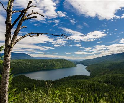
The summit of Mount Boucherie delivers spectacular 360-degree views that justify every step of the climb. Okanagan Lake stretches out below like a massive blue ribbon, its deep waters contrasting beautifully with the golden hills and green vineyards that characterize this famous wine region. On clear days, the view extends across the entire Okanagan Valley, with distant mountain ranges creating a dramatic backdrop that seems to go on forever.
The summit area provides several vantage points, allowing you to find the perfect spot for photos or simply to sit and absorb the incredible scenery. The rocky summit plateau offers enough space for groups to spread out and enjoy lunch while soaking up the panoramic vistas. Early morning and late afternoon hikes often provide the best lighting for photography and the most comfortable temperatures during summer months.
What makes the summit experience particularly rewarding is how the views unfold gradually as you climb, building to this spectacular finale. Each rocky outcrop along the way offers a preview, but nothing quite prepares you for the full panoramic sweep visible from the top.
Geological Fascination
Mount Boucherie's volcanic heritage makes it a fascinating destination for anyone interested in geology or natural history. The mountain represents one of the most accessible examples of ancient volcanic activity in the region, with rock formations that clearly display its explosive origins. As you hike, you'll notice how the distinctive volcanic rock differs markedly from the surrounding sedimentary formations visible across the valley.
The unique geology creates interesting microhabitats throughout the mountain, supporting specialized plant communities adapted to the rocky, well-drained volcanic soil. This geological diversity adds an educational element to your hike, making it particularly engaging for families with curious children or anyone wanting to understand the powerful forces that shaped this landscape millions of years ago.
The volcanic rock formations also create natural sculptures and viewing platforms that feel almost deliberately placed for maximum scenic impact. These geological features make the hike feel like a journey through time, connecting you to the ancient volcanic forces that created this distinctive landscape.
Trail Conditions and Preparation
The trails on Mount Boucherie are well-maintained and clearly marked, but the volcanic terrain requires thoughtful preparation. Sturdy hiking boots with good ankle support are absolutely essential, as the rocky surfaces can be uneven and occasionally loose. The exposed sections of trail offer little shade, making sun protection crucial during summer months when temperatures can soar.
Carry plenty of water, especially during warmer weather, as the rocky terrain and open exposure can be surprisingly dehydrating. Weather conditions can change quickly at elevation, and the summit can be significantly windier and cooler than the trailhead, so dressing in layers is recommended year-round.
Staying on designated trails is particularly important on Mount Boucherie, both for safety and environmental protection. The volcanic rock can be fragile in places, and the unique plant communities that have adapted to this specialized habitat are easily damaged by foot traffic.
Seasonal Hiking Opportunities
Mount Boucherie offers rewarding hiking experiences throughout the year, though each season brings different conditions and unique rewards. Spring hiking reveals hardy wildflowers adapted to the rocky volcanic soil, while summer provides the clearest views and warmest weather, though early morning starts are recommended to avoid the heat.
Fall brings comfortable temperatures and excellent visibility, often considered the ideal time for summit views when the air is crisp and clear. The autumn light creates particularly dramatic contrasts between the dark volcanic rock and the colorful valley below.
Winter hiking is possible but requires additional preparation for potentially icy conditions on the rocky surfaces. The exposed nature of much of the trail means snow and ice can persist longer than on more sheltered trails, making traction devices advisable during winter months.
Recommended gear for this trail


Ready to go?
Everything you need to know before you goStarting Point
The mount boucherie trails are located in West Kelowna, British Columbia. To get to the start of the trails, take Highway 97 north to West Kelowna. Turn left onto Boucherie Road and drive until you reach the end of the road. The trailhead is located at the end of the road.
When?
How much?
- Hiking shoes Essential
- → Salomon Elixir Tour Mid WP · 203.38 $
- Layered clothing Essential
- Rain jacket Essential
- Trekking poles
- → Black Diamond Trail Ergo Cork · 69.99 $
- Headlamp
- → Petzl Actik Core 625 · 103.95 $
FAQ - Frequently asked questions
Everything you need to knowThe Essential Hiking Checklist
Everything you need for your next hike. Bilingual, printable, 1 page.
Download the free checklistSimilar hikes nearby
Discover other trails you might enjoy

Big White Ski Resort
Thompson Okanagan

Cougar Canyon
Thompson Okanagan
Spectrum Lake
Thompson Okanagan
Clearwater Lake
Thompson Okanagan
Mahood Lake
Thompson Okanagan
Kentucky Lake
Thompson Okanagan
Hiking near Kelowna
45 trails to explore ~7 km away
We work hard to provide the most up-to-date and error-free data possible. If something seems incorrect, let us know! Your contribution helps the whole community.
Hikers' opinions