

Ready to explore Chimney Peak, Maine? Here's everything you need to know before you go!
Discover the trail
Trail description
Description
Chimney Peak stands as one of Maine's most challenging and rewarding hiking destinations, rising dramatically from the Maine Highlands to offer an intense mountain experience that tests even experienced hikers. This 14.6-kilometer round-trip adventure demands respect, delivering 1,494 meters of elevation gain through terrain that transitions from dense lowland forests to exposed rocky slopes near the summit.
The mountain's distinctive profile, visible from miles away, hints at the rugged climb ahead. What sets Chimney Peak apart from other Maine summits is its relentless ascent combined with the incredible diversity of ecosystems you'll encounter during the 6-hour and 15-minute journey. The trail doesn't offer many flat sections for recovery, making this a true test of endurance and preparation that separates casual hikers from serious mountain enthusiasts.
The Climbing Experience
The trail begins deceptively through dense woodlands where towering pines and maples create a cathedral-like canopy overhead. These early miles allow you to settle into a rhythm before the real work begins, but don't be fooled by the gentle start. As you gain elevation, the forest composition shifts noticeably—hardwoods give way to more resilient conifers adapted to the harsher conditions higher up the mountain.
Multiple babbling brooks cross the trail throughout the ascent, providing natural rest stops and opportunities to refill water bottles if you're carrying purification tablets. The sound of running water becomes a welcome companion during the steeper sections, where the trail demands careful foot placement and steady breathing. These water crossings also serve as natural markers of your progress up the mountain.
The well-marked and maintained trail system ensures you won't lose your way, but the "very hard" difficulty rating becomes apparent as you climb. Expect sustained steep sections that will challenge your cardiovascular fitness and leg strength. The trail surface varies from soft forest floor to rocky scrambles, requiring sturdy hiking boots with good ankle support. Some sections demand using your hands for balance, transforming the hike into a full-body workout.
Wildlife and Natural Features
Chimney Peak's diverse elevation zones support an impressive array of wildlife that changes as you climb. In the lower elevations, white-tailed deer browse quietly in the early morning hours, while red foxes occasionally dart across the trail. The varied bird life includes everything from common forest species like chickadees and nuthatches to the haunting calls of loons echoing from distant lakes visible through the trees.
As you gain elevation, watch for different bird species adapted to mountain conditions. The changing forest composition creates distinct habitats that support this diversity, making the climb as much a nature study as a physical challenge. Keep your eyes open for signs of black bears, though encounters are rare due to the heavy foot traffic on this popular peak.
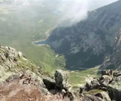
The geological features become increasingly dramatic as you ascend. Massive granite outcroppings emerge from the forest, creating natural viewing platforms and photo opportunities. These rocky sections provide glimpses of what awaits at the summit while offering brief respites from the tree-enclosed trail.
Summit Rewards
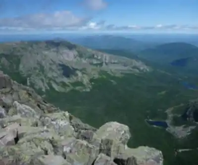
The panoramic views from Chimney Peak's summit justify every challenging step of the ascent. The sweeping vista encompasses Maine's characteristic landscape of endless forests punctuated by gleaming lakes and rolling hills that stretch to the horizon. On clear days, the view extends far enough to appreciate the true scale of Maine's wilderness, with layer upon layer of forested ridges fading into the distance.
The summit area provides space to rest, refuel, and fully absorb the accomplishment of reaching this demanding peak. The exposed rocky summit offers 360-degree views, making it an ideal spot for photography and simply appreciating the vast wilderness that defines this region of Maine. The sense of isolation and wildness from this vantage point reminds you why Maine's highlands remain one of the most pristine wilderness areas in the eastern United States.
Seasonal Considerations
While Chimney Peak remains accessible throughout the year, each season transforms both the challenge and the rewards of this hike. Spring brings vibrant green foliage and blooming wildflowers that carpet the forest floor, though trails may be muddy from snowmelt and spring rains. The stream crossings can become more challenging during this season, requiring extra caution.
Summer offers the most stable weather conditions and full access to all trail features, with lush greenery providing shade during the demanding ascent. However, the combination of heat and the sustained elevation gain makes proper hydration even more critical during the warmer months.
Fall transforms Chimney Peak into a spectacular display as the hardwood forests explode into fiery reds, brilliant oranges, and golden yellows. The contrast between the colorful deciduous trees and the dark green conifers creates a stunning tapestry visible from the summit views. This season often provides the clearest air for maximum visibility from the peak, making it the most popular time to tackle this challenging hike.
Winter hiking on Chimney Peak requires advanced preparation and winter mountaineering skills. Snow-covered trails create a peaceful winter wonderland, but the already challenging terrain becomes significantly more demanding. Microspikes or snowshoes become essential, and the risk of hypothermia increases dramatically with elevation and exposure.
Essential Preparation
The very hard difficulty rating of Chimney Peak demands thorough preparation and appropriate gear. Pack significantly more water than you think you'll need—the sustained elevation gain and 6-hour duration mean you'll be working hard for an extended period. High-energy snacks and a substantial lunch become fuel for the demanding ascent and crucial for maintaining energy during the descent, which can be just as taxing on your knees and legs.
Weather conditions can change rapidly with elevation, so pack layers appropriate for temperatures potentially 20-30 degrees cooler than at the trailhead. Rain gear remains essential regardless of the forecast, as mountain weather can shift quickly and dramatically. The exposed summit can be particularly brutal in wind and weather.
Given the remote nature and challenging terrain of Chimney Peak, always inform someone of your detailed hiking plans, including expected return time. Cell phone coverage may be spotty or nonexistent, making self-reliance and preparation even more critical. Consider carrying a whistle and basic first aid supplies for emergencies.
Check current trail conditions before departing, especially during spring when snowmelt can create hazardous stream crossings, or after severe weather that might have caused trail damage. The combination of Chimney Peak's elevation gain, distance, and technical difficulty makes this a hike where preparation and respect for the mountain's challenges ensure both safety and an unforgettable Maine wilderness experience.
Recommended gear for this trail


Ready to go?
Everything you need to know before you goStarting Point
The Chimney Peak trails are located in the town of Carrabassett Valley, Maine. To get to the start of the trails, take Route 27 north from Kingfield, Maine. The trailhead is located on the left side of the road, just past the Sugarloaf Mountain Resort.
When?
How much?
- Hiking shoes Essential
- → Salomon Elixir Tour Mid WP · 203.38 $
- Layered clothing Essential
- Rain jacket Essential
- Trekking poles
- → Black Diamond Trail Ergo Cork · 69.99 $
- Headlamp
- → Petzl Actik Core 625 · 103.95 $
FAQ - Frequently asked questions
Everything you need to knowThe Essential Hiking Checklist
Everything you need for your next hike. Bilingual, printable, 1 page.
Download the free checklistSimilar hikes nearby
Discover other trails you might enjoy

Katahdin
Maine Highlands
Little Spencer Mountain
Maine Highlands
Pleasant Pond Mountain
Maine Highlands
Katahdin Lake
Maine Highlands
Abol Stream Trail
Maine Highlands
Baxter Peak
Maine Highlands
Hiking near Bangor
0 trails to explore ~123 km away
We work hard to provide the most up-to-date and error-free data possible. If something seems incorrect, let us know! Your contribution helps the whole community.
Hikers' opinions