

Ready to explore Katahdin? Here's everything you need to know before you go!
Discover the trail

Trail description
Description
Mount Katahdin stands as Maine's highest peak at 5,267 feet, marking the dramatic northern terminus of the Appalachian Trail in Baxter State Park. This massive granite monolith dominates the landscape of Piscataquis County, offering some of the most challenging and rewarding hiking experiences in New England. The mountain's name comes from the Penobscot word "Kette-Adene," meaning "The Greatest Mountain," and it lives up to that designation with its imposing presence and technical terrain.
The mountain is part of the broader Appalachian Mountain system but stands distinctly apart from other peaks in the region. Unlike the rolling hills that characterize much of Maine's interior, Katahdin rises abruptly from the surrounding forests, creating a dramatic skyline visible for miles. The peak actually consists of several distinct summits connected by a knife-edge ridge, with Baxter Peak serving as the true summit and the official end point of the Appalachian Trail.
Trail Options and Terrain
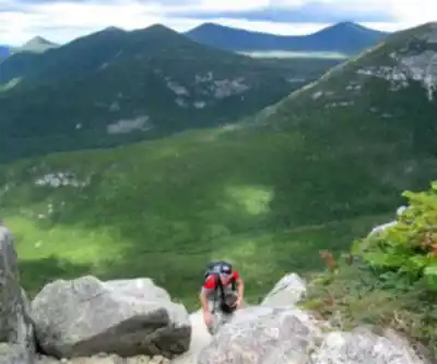
Katahdin offers multiple route options for hikers, each presenting unique challenges and perspectives on this iconic mountain. The most popular approach follows the Hunt Trail, which coincides with the Appalachian Trail for its final stretch. This route provides a direct but demanding path to the summit, featuring steep rocky sections, exposed granite slabs, and technical scrambling near the top.
The Abol Trail presents another option, known for its relentless steep grade that gains elevation quickly through dense forest before emerging onto the mountain's upper reaches. The Cathedral Trail offers perhaps the most technical challenge, requiring hands-on scrambling over large granite boulders and through narrow passages between rock formations.
For those seeking a longer but more gradual approach, the Saddle Trail connects to the Cathedral Trail and provides access to the dramatic Knife Edge traverse. This exposed ridge walk between Pamola Peak and Baxter Peak ranks among the most thrilling and intimidating sections of trail in the Northeast, with steep drop-offs on both sides and exposure to rapidly changing weather conditions.
The terrain varies dramatically as you ascend. The lower elevations feature typical Maine forest with birch, maple, and evergreen trees creating a dense canopy. As you climb higher, the forest transitions to stunted spruce and fir before giving way to alpine conditions above treeline. The upper mountain consists primarily of exposed granite, requiring careful foot placement and occasional use of hands for balance and progress.
The Summit Experience
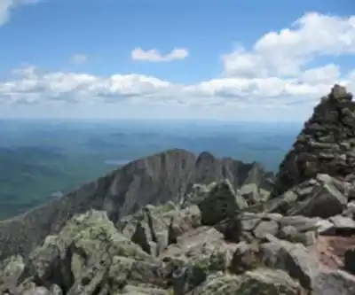
Reaching Baxter Peak delivers spectacular panoramic views that justify the strenuous effort required to get there. On clear days, the vista extends across the vast Maine wilderness, with countless lakes, rivers, and forested ridges stretching to the horizon. The summit provides views of Chimney Pond nestled in the mountain's cirque, the distinctive profile of the Knife Edge, and the sprawling wilderness of Baxter State Park extending in all directions.
The summit itself features the famous Appalachian Trail terminus sign, marking the end of the 2,190-mile footpath. This weathered wooden sign serves as a pilgrimage site for thru-hikers completing their journey, but day hikers also find it meaningful as a symbol of achievement after the demanding climb. The exposed granite summit plateau offers plenty of space to rest and take in the incredible scenery, though weather conditions can change rapidly.
Weather conditions on the summit can shift dramatically and without warning, even when conditions at the trailhead seem favorable. The exposed granite surfaces become extremely slippery when wet, and high winds are common year-round. The mountain creates its own weather patterns, often shrouded in clouds even when surrounding areas remain clear.
Physical Demands and Preparation
This hike represents a serious physical undertaking that demands respect and proper preparation. The combination of steep granite slabs, exposure to weather, and remote location means that rescue operations are difficult and time-consuming. Hikers should possess solid experience on challenging terrain before attempting Katahdin, as the consequences of poor decisions or inadequate preparation can be severe.
Proper footwear with aggressive tread becomes essential for navigating the granite surfaces safely, especially in wet conditions. Many sections require careful route-finding across unmarked granite faces, following cairns and painted blazes to stay on track. The technical nature of the terrain means that hiking poles may be more hindrance than help on the upper mountain, where hands are frequently needed for balance and progress.
The exposed nature of the upper mountain means you'll be completely at the mercy of the elements once above treeline. Layered clothing becomes crucial, as temperatures can vary dramatically between the forested lower slopes and the windswept summit. Even experienced hikers often underestimate how quickly conditions can deteriorate on Katahdin's exposed granite faces.
Seasonal Considerations
Katahdin's hiking season is relatively short, typically running from late May through mid-October, depending on snow conditions and weather. Even during the official hiking season, winter-like conditions can occur on the summit, with snow possible in any month and temperatures dropping well below freezing.
Early season hiking often involves navigating snow patches and ice on the upper mountain, while late season brings the spectacular fall foliage that makes Maine famous. Summer conditions provide the most stable weather windows, but also bring the largest crowds and the need for early starts to secure parking and avoid afternoon thunderstorms.
The mountain's position in northern Maine means that weather systems arrive with little warning, and conditions can deteriorate rapidly. Park rangers actively monitor weather conditions and will close trails when conditions become dangerous, particularly when high winds or severe weather threaten the exposed upper elevations.
Access and Logistics
All routes to Katahdin's summit begin within Baxter State Park, which requires advance planning and reservations for both day use and camping. The park operates under strict capacity limits to preserve the wilderness experience and protect the fragile mountain environment. Day-use reservations are required during peak season, and these often fill up weeks or months in advance.
The park's remote location means that the nearest services are in Millinocket, approximately 20 miles from the park entrance. This distance requires careful planning for food, fuel, and emergency supplies, as no services exist within the park boundaries. The park maintains several campgrounds that provide base camps for multi-day visits, but these also require advance reservations and fill quickly during peak season.
Getting an early start becomes crucial not just for weather considerations, but also for securing parking at popular trailheads. The park's commitment to preserving the wilderness experience means that when parking areas fill up, access is restricted until spaces become available.
Recommended gear for this trail


Ready to go?
Everything you need to know before you goStarting Point
The best way to get to the start of the trails at the katahdin is to drive to Millinocket, Maine and then take the katahdin Loop Road to the trailhead.
The best way to get to the start of the trails at the katahdin is to drive to Millinocket, Maine and then take the katahdin Loop Road to the trailhead.
The best way to get to the start of the trails at the katahdin is to drive to Millinocket, Maine and then take the katahdin Loop Road to the trailhead.
The best way to get to the start of the trails at the katahdin is to drive to Millinocket, Maine and then take the katahdin Loop Road to the trailhead.
When?
How much?
- Hiking shoes Essential
- → Salomon Elixir Tour Mid WP · 203.38 $
- Layered clothing Essential
- Rain jacket Essential
- Trekking poles
- → Black Diamond Trail Ergo Cork · 69.99 $
- Headlamp
- → Petzl Actik Core 625 · 103.95 $
FAQ - Frequently asked questions
Everything you need to knowThe Essential Hiking Checklist
Everything you need for your next hike. Bilingual, printable, 1 page.
Download the free checklistSimilar hikes nearby
Discover other trails you might enjoy

Chimney Peak, Maine
Maine Highlands

Pleasant Pond Mountain
Maine Highlands
Katahdin Lake
Maine Highlands
Abol Stream Trail
Maine Highlands
Baxter Peak
Maine Highlands
Little Spencer Mountain
Maine Highlands
Hiking near Bangor
0 trails to explore ~123 km away
We work hard to provide the most up-to-date and error-free data possible. If something seems incorrect, let us know! Your contribution helps the whole community.
Hikers' opinions