

Ready to explore Baldpate Mountain, Maine? Here's everything you need to know before you go!
Discover the trail
Trail description
Description
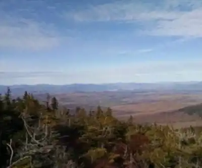
Baldpate Mountain is one of the more rewarding hikes in Maine's Western Mountains, sitting in Oxford County and offering two distinct summits connected by the Appalachian Trail. The mountain's two main peaks — West Peak at 3,662 feet (1,116 m) and East Peak — are separated by a col, with West Peak standing 222 feet (68 m) above that low point between them. The name "Baldpate" is fitting: both summits feature open, exposed terrain that gives hikers sweeping views in multiple directions.
The Terrain
The Appalachian Trail is the primary route across Baldpate, running from Grafton Notch to Surplus Mountain and crossing both peaks along the way. Grafton Notch, to the southwest, marks the conventional northeast end of the Mahoosuc Range, so Baldpate sits right at a meaningful geographic boundary — you're essentially stepping off the Mahoosucs and into a different stretch of Maine wilderness.
The mountain is flanked by notable neighbors: Surplus Mountain to the north, Black Mountain to the northeast, and Mount Hittie to the southeast. Across Grafton Notch to the southwest stands Old Speck Mountain, one of Maine's higher peaks. That context matters on the trail — the views from Baldpate's open summits include this surrounding ridgeline, and on a clear day the landscape reads like a map of the Western Mountains.
The hike covers 11.59 km with 1,152 m of elevation gain, which puts it firmly in the moderate-to-strenuous range despite the "moderate" difficulty rating. Plan for around 6 hours 30 minutes on the trail. The elevation gain is consistent and real — this isn't a flat walk with one short climb. Hikers should be comfortable with sustained ascent and rocky footing typical of Maine's higher terrain.
Watershed and Setting
Baldpate sits within the watershed of the Androscoggin River, though the water leaving the mountain takes different paths depending on which side you're on. The northwest slopes drain into the Swift Cambridge River, which feeds into the Dead Cambridge River and eventually Umbagog Lake — the actual source of the Androscoggin. The southeast and southwest sides shed water into the Bear River, which also joins the Androscoggin downstream. The northeast side drains into the West Branch of the Ellis River, another Androscoggin tributary. All of it eventually reaches Merrymeeting Bay and the Gulf of Maine.
This isn't just trivia — it gives you a sense of how remote and hydrologically intact this corner of Maine is. The streams you cross or hear on the approach are part of a larger, largely undeveloped watershed.
The Appalachian Trail Connection
Baldpate Mountain is a named stop on the Appalachian Trail, the 2,170-mile National Scenic Trail running from Georgia to Maine. For thru-hikers, Baldpate comes near the end of a long journey — it's one of the final significant climbs before Katahdin. For day hikers and section hikers, that context adds something to the experience: the trail here is well-maintained and well-marked, and you're walking the same path as thousands of long-distance hikers every year.
The open summits are a highlight of this section of the AT in Maine. After stretches of dense boreal forest, the exposed rock on both peaks delivers the kind of panoramic payoff that makes the climb worthwhile.
Practical Notes
- Trailhead access: The standard approach uses Grafton Notch, which is accessible by road through Oxford County.
- Distance: 11.59 km round trip
- Elevation gain: 1,152 m
- Estimated time: 6 hours 30 minutes
- Difficulty: Moderate — though the elevation gain warrants solid fitness and proper footwear
- Trail: Appalachian Trail, running Grafton Notch to Surplus Mountain via both Baldpate peaks
Bring enough water for a full day out — the terrain is exposed on the upper sections, and the climb is sustained enough that you'll feel it by the time you reach the col between the two peaks.
Recommended gear for this trail


Ready to go?
Everything you need to know before you goStarting Point
The Baldpate Mountain trails are located in Georgetown, Maine. To get to the start of the trails, take Route 133 north from Bath or south from Brunswick. The trailhead is located on the left side of the road about 1.5 miles from the intersection of Routes 133 and 237.
When?
How much?
- Hiking shoes Essential
- → Salomon Elixir Tour Mid WP · 203.38 $
- Layered clothing Essential
- Rain jacket Essential
- Trekking poles
- → Black Diamond Trail Ergo Cork · 69.99 $
- Headlamp
- → Petzl Actik Core 625 · 103.95 $
FAQ - Frequently asked questions
Everything you need to knowThe Essential Hiking Checklist
Everything you need for your next hike. Bilingual, printable, 1 page.
Download the free checklistSimilar hikes nearby
Discover other trails you might enjoy

Long Mountain
Western Mountains
Pleasant Mountain
Western Mountains
Witt's End Trail
Western Mountains
Tumbledown Mountain
Western Mountains
Bear Mountain Inn + Barn Maine
Western Mountains
Bald Pate Mountain
Western Mountains
Hiking near North Conway
0 trails to explore ~65 km away
We work hard to provide the most up-to-date and error-free data possible. If something seems incorrect, let us know! Your contribution helps the whole community.
Hikers' opinions