

Ready to explore Goose Eye Mountain, Maine? Here's everything you need to know before you go!
Discover the trail
Trail description
Description
Goose Eye Mountain rises to 3,870 feet in Maine's Mahoosuc Range, sitting squarely in the Western Mountains region and offering one of the most demanding summit hikes in the state. At 13.4 kilometers round trip with 1,177 meters of elevation gain, this is a full-day commitment — plan on roughly 5.5 hours of moving time, and more if you factor in breaks and summit time. The "very hard" rating isn't marketing; this trail earns it.
Trail Character and Terrain
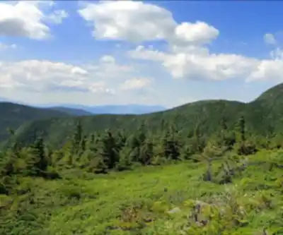
The Goose Eye Trail starts reasonably enough, pulling you into dense mixed forest where the grade is manageable and the footing is soft. Conifers dominate the canopy in the lower sections, and the trail has a classic Maine backcountry feel — rooted, damp in spots, and quiet. Don't let this lull you into a false sense of ease.
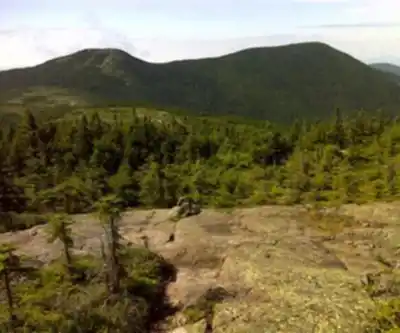
As you gain elevation, the trail's personality shifts hard. Moderate forest walking gives way to sustained rocky climbing, and eventually you're picking your way across granite slabs and scrambling around boulders that have no interest in making your life easy. The upper sections involve genuinely technical movement — not technical in a ropes-and-harness sense, but technical enough that you need to think about every foot placement. Wet granite here is legitimately slippery, and a misstep on the steeper exposed sections has real consequences. Dry conditions make a meaningful difference both in safety and in how much you enjoy the experience.
The final push to the summit is where most hikers feel the accumulated effort. The climbing is steep and exposed, with little relief until you break out onto the summit rocks. It's the kind of finish that demands something from you — but that's also exactly why reaching the top feels the way it does.
Summit Views
The 3,870-foot summit delivers a full panoramic view across the Mahoosuc Range. Ridgelines roll out in every direction, with deep forested valleys dropping away between them — the kind of landscape that makes it obvious you're standing in a genuinely wild corner of the Northeast. On a clear day, Mount Washington in New Hampshire's White Mountains is visible to the southwest, its profile distinct on the horizon. That sightline puts Goose Eye in context: you're standing in the same mountain system, at a serious elevation, looking across at one of the most iconic peaks in the region.
The summit rocks offer multiple spots to settle in, eat something, and actually absorb where you are before heading back down. Take the time — the descent demands its own attention, and a few minutes at the top is worth it.
Wildlife and Natural Features
The elevation gradient along this trail creates genuinely distinct ecosystems within a single hike. The lower forested sections are moose country — look for tracks in muddy sections and be alert in early morning or evening. Songbirds are active through the forest, and the soundscape changes noticeably as you climb into the higher, more exposed terrain.
The transition from dense forest to open ridgeline happens gradually, with the vegetation getting progressively more wind-beaten and sparse as you approach the summit. Hardy alpine plants occupy the rocky crevices near the top, adapted to conditions that would finish off anything less tough. This shift from lush forest floor to exposed summit ecology is one of the more interesting aspects of the hike — you're moving through multiple environments in a single morning.
What to Bring
Given the terrain and duration, gear choices matter on this one.
- Footwear: Stiff-soled hiking boots with solid ankle support are non-negotiable. The rocky terrain is uneven and unforgiving, and trail runners that work fine on gentler hikes will leave you working harder and risking more on the upper sections.
- Water: Carry more than you think you need. The sustained effort over 5.5-plus hours, especially on the steep sections, means you'll be working hard and sweating consistently. Running short on water on a remote summit is a bad situation.
- Layers: Summit conditions can be dramatically different from what you started in at the trailhead. Wind and temperature drop quickly on exposed ridgelines, and what felt like a warm morning in the forest can turn cold fast once you're above treeline. Pack extra layers regardless of the forecast.
- Trekking poles: Genuinely useful on the descent, particularly on the steep rocky sections where your knees will be taking a beating by the time you're heading back down.
Leave No Trace
The alpine environment near Goose Eye's summit is fragile and recovers slowly from damage. Stay on established trail even when the going gets difficult — cutting switchbacks or stepping off-trail to avoid obstacles creates erosion that takes years to heal. Pack out everything you bring in, including food scraps. The wilderness character of this area is part of what makes it worth the effort, and it stays that way only when every visitor treats it accordingly.
Recommended gear for this trail


Ready to go?
Everything you need to know before you goStarting Point
To access the hiking trails, you can start from one of several trailheads:
Goose Eye Trailhead: Located at Success Pond Road, Berlin, NH 03570. This is a common starting point for hikers.
Wright Trailhead: Found at Bull Branch Road, Newry, ME 04261. This trailhead offers another route to begin your hike.
Ensure you check local maps and conditions before heading out, as road accessibility can vary with weather and season.
When?
How much?
- Hiking shoes Essential
- → Salomon Elixir Tour Mid WP · 203.38 $
- Layered clothing Essential
- Rain jacket Essential
- Trekking poles
- → Black Diamond Trail Ergo Cork · 69.99 $
- Headlamp
- → Petzl Actik Core 625 · 103.95 $
FAQ - Frequently asked questions
Everything you need to knowThe Essential Hiking Checklist
Everything you need for your next hike. Bilingual, printable, 1 page.
Download the free checklistSimilar hikes nearby
Discover other trails you might enjoy

Long Mountain
Western Mountains
Pleasant Mountain
Western Mountains
Witt's End Trail
Western Mountains
Tumbledown Mountain
Western Mountains
Bear Mountain Inn + Barn Maine
Western Mountains
Bald Pate Mountain
Western Mountains
Hiking near North Conway
0 trails to explore ~51 km away
We work hard to provide the most up-to-date and error-free data possible. If something seems incorrect, let us know! Your contribution helps the whole community.
Hikers' opinions