Hiking Mahoosuc Mountain, Maine - panoramic view
--°C
Loading...
See forecast →

Hiking in Mahoosuc Mountain, Maine: trails, map and practical info

Western Mountains • Maine

4.0 Appreciated by 12 hikers
François Dumaine
By François DumaineContributor since 2015Updated 01/04/2026
Difficulty
Very hard
Distance
19 km
Elevation
1,049 m
Duration
7h30
Max altitude
1,150 m

Home to the infamous "toughest mile" on the Appalachian Trail through Mahoosuc Notch's boulder maze, this very hard 18.8 km trek in Maine's Western Mountains demands 8 to 10 hours and 1049 m of elevation gain.

Recommended for :
Intermediate hikers

Ready to explore Mahoosuc Mountain, Maine? Here's everything you need to know before you go!

Discover the trail

2 community photos

Trail description

Description

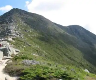
Mahoosuc Mountain stands as one of Maine's most formidable hiking challenges, anchoring the rugged Mahoosuc Range in the state's western mountains. This isn't your typical weekend stroll—the 18.8-kilometer trek demands 8 to 10 hours of sustained effort and delivers 1,049 meters of elevation gain through some of the most technically demanding terrain in New England.

The mountain's reputation centers on the legendary Mahoosuc Notch, a boulder-choked ravine that Appalachian Trail hikers know as the "toughest mile" on the entire 2,190-mile trail. Here, the path disappears into a chaotic jumble of house-sized granite blocks, forcing you to crawl, squeeze, and scramble through dark crevices where ice lingers well into summer. What looks like a short section on the map can easily consume two hours as you navigate this natural obstacle course, testing both your route-finding skills and your comfort with exposure.

Trail Experience and Terrain

The approach to Mahoosuc Mountain takes you through dense mixed forests of spruce, fir, and hardwoods, where the trail climbs steadily over rocky, root-laced terrain. Early sections wind through typical Maine woodland, but as elevation increases, the character shifts dramatically. Granite slabs become more frequent, and the forest opens to reveal glimpses of the surrounding peaks.

Beyond the notorious notch, the trail continues its relentless climb over exposed ridgelines where weather can change rapidly. The final push to the summit involves scrambling over bare rock faces and navigating narrow ledges that demand sure footing and a head for heights. This isn't a trail where you can zone out—constant attention to foot placement and route selection keeps you fully engaged throughout the day.

The payoff comes in the form of sweeping panoramic views across Maine's vast wilderness. From the summit and various viewpoints along the ridge, you'll see an unbroken carpet of forest stretching to the horizon, punctuated by distant peaks and the occasional glint of remote lakes. On clear days, the White Mountains of New Hampshire dominate the western skyline, while the Rangeley Lakes region spreads out to the north.

Wildlife and Natural Features

The Mahoosuc Range supports a robust population of Maine's iconic wildlife. Moose frequent the lower elevations, particularly in boggy areas and near water sources, with early morning and late afternoon offering the best viewing opportunities. Black bears are common throughout the region, making proper food storage essential for overnight trips. The diverse elevation zones support an impressive array of bird species, from deep-woods dwellers like pileated woodpeckers in the valleys to alpine specialists on the exposed ridges.

The geological features here tell the story of ancient mountain-building and glacial sculpting. The massive boulder fields that create the notch resulted from freeze-thaw cycles splitting the granite bedrock, while glacial action carved the dramatic U-shaped valleys visible from the summit. These same forces created the numerous caves and crevices that make navigation through the notch so challenging.

Seasonal Considerations

Each season transforms the Mahoosuc experience completely. Fall brings spectacular foliage displays as the hardwood forests explode in brilliant reds, oranges, and yellows, typically peaking in late September to early October. However, this popular season also means sharing the trail with more hikers and dealing with potentially unpredictable weather as winter approaches.

Winter hiking here requires advanced skills and specialized equipment. The notch becomes even more treacherous with ice and snow filling the gaps between boulders, while the exposed ridges face the full fury of Maine's winter storms. Only experienced winter mountaineers should attempt this route during the cold months.

Spring brings its own challenges as snowmelt creates muddy, slippery conditions and swells the numerous stream crossings. The notorious Maine mud season can make the lower sections nearly impassable, while ice may still lurk in the shadowy depths of the notch well into May. However, spring also awakens the wildflower displays and brings migrating birds back to the region.

Summer offers the most stable conditions with lush green forests and generally clear weather, though afternoon thunderstorms can develop quickly on the exposed ridges. The dense canopy provides welcome shade during the forest sections, but the open summit areas can be surprisingly hot and exposed to intense sun.

Planning Your Visit

The very hard difficulty rating reflects both the technical challenges and the sustained physical demands of this route. The combination of distance, elevation gain, and technical terrain makes this suitable only for experienced hikers in excellent physical condition. The boulder scrambling through Mahoosuc Notch requires basic rock climbing skills and comfort with exposure.

Most hikers tackle this as a challenging day hike, but the region also offers excellent opportunities for multi-day backpacking expeditions. Several established campsites along the Appalachian Trail corridor provide options for breaking the journey into more manageable segments, allowing time to fully appreciate the unique character of this remarkable landscape.

Water sources are generally reliable throughout the hiking season, but the exposed nature of much of the route means weather protection is crucial. Conditions can deteriorate rapidly on the ridges, and the technical terrain of the notch becomes significantly more dangerous when wet.

Ready to go?

Everything you need to know before you go

Where?

Address
Not available
GPS coordinates
44.548539, -70.986107
Phone
Not available

Starting Point

To access the hiking trails, you can start at several trailheads:

  1. Grafton Notch State Park Trailhead: Located on Route 26 in Newry, Maine. There is a parking area available for hikers.

  2. Success Pond Road Trailhead: Accessible via Success Pond Road, which is off Route 16 near Berlin, New Hampshire. This road leads to various entry points along the trails.

  3. Speck Pond Trailhead: Found at the end of Success Pond Road, this trailhead provides access to the trails from a different angle.

Ensure your vehicle is suitable for unpaved roads if using Success Pond Road, as conditions can vary.

When?

Opening hours
No information
Varies by season
Best season
Fall
Spectacular colors
Best time
Early morning
Less crowded
Weather (next days)
Loading

How much?

Entry fees
Adult
Not available
Child
What to bring?
Gear
  • Hiking shoes Essential
  • Layered clothing Essential
  • Rain jacket Essential
  • Trekking poles
  • Headlamp
Download the PDF checklist
Water & food
2L minimum
No water point on the trail
Bring energy snacks for a 4h+ hike
Good to know
Park rules
No dogs
Safety
Download the GPX before you go
Limited cellular coverage on the trail
Slippery after rain
Be careful on rocky sections
In an emergency
Emergency
911
Parking GPS
44.548539, -70.986107
Center
Not available

Hikers' opinions

4.0
6 Reviews
R2
Review 2
Feb 8, 2024
Beautiful mountain scenery throughout this demanding hike. The Mahoosuc range delivers spectacular views despite the tough 18.8km distance and significant elevation gain. Access via Grafton Notch State Park worked well, though parking fees apply. Very hard difficulty rating is accurate - this trail requires good fitness and preparation.
R2
Review 2
Feb 3, 2024
Beautiful trail with stunning Western Mountains scenery throughout the hike. The 18.8km distance provides plenty of opportunities to enjoy Maine's wilderness, though the 1049m elevation gain makes it quite challenging. Plan for a full day as it took us nearly 9 hours to complete. Worth every step despite the parking fees.
R1
Review 1
Jan 15, 2024
My favorite place. This challenging 18.8km trail through Mahoosuc Mountain offers incredible wilderness experience in Maine's Western Mountains. The 1049m elevation gain makes it very demanding but absolutely worth it for the stunning views and rugged terrain. Plan for 8-10 hours and come prepared for a serious mountain adventure.
R1
Review 1
Jan 15, 2024
My favorite place. This challenging 18.8km trail through Mahoosuc Mountain offers incredible views and a true test of endurance with 1049m of elevation gain. The 8-10 hour journey is demanding but absolutely rewarding. Despite the very hard difficulty level and access fees, the wilderness experience is unmatched. Perfect for experienced hikers seeking adventure.
LT
Leo Thomas
Feb 20, 2015
My favorite place.

FAQ - Frequently asked questions

Everything you need to know
Very hard
1049.00 M
1150.00 M
7h30
No
No
The Mahoosuc Mountain trail is rated as very hard, requiring significant hiking experience and physical fitness. This 18.8 km trail involves 1049 m of elevation gain and takes 8 to 10 hours to complete.
The Mahoosuc Mountain trail is 18.8 km long and typically takes 8 to 10 hours to complete. The duration depends on your fitness level and hiking pace given the challenging terrain.
The Mahoosuc Mountain trail has an elevation gain of 1049 m. This significant elevation change contributes to the trail's very hard difficulty rating.
No, dogs are not allowed on the Mahoosuc Mountain trail. Plan accordingly if you typically hike with your pet.
No, Mahoosuc Mountain is not suitable for beginners as it is rated very hard. This trail requires significant hiking experience, excellent physical fitness, and proper preparation for the 18.8 km distance and 1049 m elevation gain.
Didn't find your answer?
Free 1 pages

The Essential Hiking Checklist

Everything you need for your next hike. Bilingual, printable, 1 page.

Download the free checklist
Top 10 best hiking in Western Mountains
Our ranking based on hiker reviews

Hiking near North Conway

0 trails to explore ~56 km away

View trails
Did you spot an error?

We work hard to provide the most up-to-date and error-free data possible. If something seems incorrect, let us know!

Update : June 2026