

Ready to explore Mount Abraham, Maine? Here's everything you need to know before you go!
Discover the trail
Trail description
Description
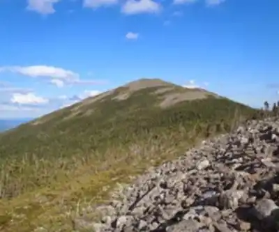
Mount Abraham rises to 4,049 feet in western Maine's Longfellow Mountains, earning its spot among the state's sought-after 4,000-footers. Known locally as "Mount Abram," this peak delivers one of the region's most complete alpine experiences — a demanding climb through varied terrain that opens into a genuine above-treeline environment with sweeping views across the Carrabassett Valley.
What sets Mount Abraham apart from most Maine summits is that it actually breaks out of the trees. Many peaks in the state stay forested all the way to the top, but Mount Abraham transitions into a true alpine zone where exposed bedrock, low-growing specialized plants, and wide-open skies define the final stretch. The experience feels closer to the White Mountains than to a typical Maine hike, and that contrast is a big part of why people keep coming back.
The Fire Warden's Trail
The Fire Warden's Trail is the main route to the summit and the one most hikers use. The round trip covers 12.39 kilometers with 1,234 meters of elevation gain — numbers that put this squarely in "very hard" territory. Budget 5.5 to 7 hours for the full outing, and be honest with yourself about your fitness level before you commit.
The trail starts in dense mixed forest, where roots, rocks, and muddy patches are the norm, particularly during spring snowmelt or after a stretch of rain. The lower section climbs steadily through hardwood forest that gradually gives way to spruce and fir as elevation builds. It's a manageable grade at first, enough to warm up your legs without burning them out early.
The upper section is where the trail earns its rating. The terrain gets steeper and rockier, demanding more attention with every step. As you near treeline, the forest thins and the exposure increases noticeably. On windy days, you'll feel the mountain's full personality here — the sheltered forest is behind you, and there's nothing between you and whatever the weather has decided to do.
The final push to the summit crosses open rocky ground where cairns mark the route. In clear conditions, the way is obvious. In fog or low visibility, those cairns become genuinely important, so pay attention to them on the way up so you can follow them back down if conditions shift.
Summit and Alpine Zone
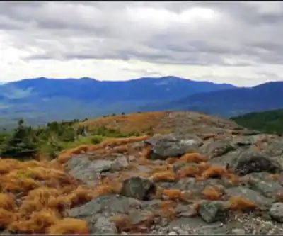
The summit area is the payoff for everything the trail asks of you. Above treeline, the landscape opens into a broad alpine zone of exposed bedrock and low-growing plants that have adapted to survive short growing seasons, relentless wind, and harsh high-elevation conditions. It's a fragile environment — stay on rock surfaces when possible to avoid damaging the vegetation that takes years to recover from a single careless footstep.
The views from the top are expansive. The Carrabassett Valley spreads out below, and on a clear day, Mount Katahdin's distinctive profile is visible on the northeastern horizon. The panorama rewards the effort in a way that's hard to overstate after a long, steep climb.
That said, the summit's exposed nature means conditions can change fast. A comfortable morning at the trailhead can become a cold, windy, low-visibility situation by the time you reach the top. This isn't a reason to avoid the mountain — it's a reason to prepare for it properly.
Historical Background
The trail's name tells its own story. Mount Abraham's summit hosted a fire lookout tower from 1914 to 1965, part of Maine's broader network of fire detection stations that kept watch over the surrounding wilderness during fire season. Fire wardens climbed this same route regularly, scanning for smoke across the landscape below.
The tower is gone, but its foundation remains at the summit — a quiet reminder of the mountain's working history and the people who made that climb as a job rather than a recreational choice. The Fire Warden's Trail follows the original supply and access route to the lookout, which explains its direct, no-nonsense approach to the top. It wasn't designed for scenery; it was designed to get people up and down efficiently.
What to Bring and How to Prepare
Mount Abraham is not a hike to wing. The combination of distance, elevation gain, rocky terrain, and exposed summit conditions means preparation matters more here than on shorter, lower peaks.
- Footwear: Sturdy hiking boots with solid ankle support are essential. The rocky terrain on the upper trail and the descent in particular will test your footing, and trail runners or casual shoes won't cut it.
- Water: There are no reliable water sources on the trail, so everything you need must come from the trailhead. Carry more than you think you'll need — the physical output on a hike this long and steep adds up quickly.
- Layers: Bring wind protection and warm clothing regardless of how the morning feels. The alpine zone at the summit operates by its own weather rules, and being underdressed up there is a real problem.
- Timing: Start early. A 5.5 to 7-hour hike leaves little margin for error if you begin late, especially during fall when daylight is shorter. Getting caught by darkness on this terrain is a situation worth avoiding entirely.
- Weather check: Check the forecast before you go, and factor in that summit conditions will be more severe than what's predicted for lower elevations. Wind, cold, and sudden changes are part of the mountain's character.
The "very hard" difficulty rating reflects both the physical demands and the technical nature of the rocky terrain. Hikers should be comfortable with long, steep climbs and confident navigating uneven, potentially slippery surfaces. If you're new to serious mountain hiking, building up to Mount Abraham with some easier peaks first is a smart approach.
Terrain and Ecosystem Highlights
One of the more interesting aspects of hiking Mount Abraham is watching the forest change around you as you climb. The lower trail moves through mixed hardwood forest before transitioning to the classic boreal spruce-fir zone that dominates the mid-elevations. Then, as you approach the summit, the trees shrink and thin until they disappear entirely into the open alpine environment above.
That alpine zone is genuinely rare in Maine. The specialized plants growing in the summit area have adapted to conditions that would stress most vegetation — short summers, thin soils, constant wind exposure, and heavy snowpack. Observing this ecosystem up close is one of the quieter rewards of reaching the top, separate from the views and the satisfaction of the climb itself.
Recommended gear for this trail


Ready to go?
Everything you need to know before you goStarting Point
The Mount Abraham trails are located in the town of Abbot, Maine. To get to the start of the trails, take Route 2 west from Bangor and turn left onto Route 6. Follow Route 6 for about 9 miles until you reach the town of Abbot. The trailhead is located on the left side of the road.
When?
How much?
- Hiking shoes Essential
- → Salomon Elixir Tour Mid WP · 203.38 $
- Layered clothing Essential
- Rain jacket Essential
- Trekking poles
- → Black Diamond Trail Ergo Cork · 69.99 $
- Headlamp
- → Petzl Actik Core 625 · 103.95 $
FAQ - Frequently asked questions
Everything you need to knowThe Essential Hiking Checklist
Everything you need for your next hike. Bilingual, printable, 1 page.
Download the free checklistSimilar hikes nearby
Discover other trails you might enjoy

Long Mountain
Western Mountains
Pleasant Mountain
Western Mountains
Witt's End Trail
Western Mountains
Tumbledown Mountain
Western Mountains
Bear Mountain Inn + Barn Maine
Western Mountains
Bald Pate Mountain
Western Mountains
Hiking near North Conway
0 trails to explore ~120 km away
We work hard to provide the most up-to-date and error-free data possible. If something seems incorrect, let us know! Your contribution helps the whole community.
Hikers' opinions