Ready to explore Mount Redington, Maine? Here's everything you need to know before you go!
Discover the trail
Trail description
Description
Mount Redington rises to 4,010 feet in Maine's Western Mountains, offering a true wilderness experience for hikers willing to venture beyond maintained trails. This peak stands apart from the typical New England hiking scene—while it reaches the elevation threshold for the region's coveted 4,000-footer list, it's excluded due to the absence of an official trail to its summit. This technicality becomes Mount Redington's greatest asset, creating an adventure that rewards self-reliant hikers with solitude and genuine backcountry navigation challenges.
The mountain sits in a landscape of dense mixed forests, rolling terrain, and seasonal streams that characterize Maine's interior wilderness. Unlike the well-trodden paths of nearby peaks, Mount Redington requires bushwhacking skills and careful route-finding, making it an ideal destination for experienced hikers looking to test their backcountry abilities. The terrain varies from gentle forest walking to steeper climbs through thick vegetation, demanding both physical endurance and mental focus as you pick your way through unmarked wilderness.
The Hiking Experience
Reaching Mount Redington's summit involves approximately 1,219 meters of elevation gain, typically requiring 6 to 8 hours for the complete journey. The most common approach utilizes the Appalachian Trail or various logging roads that crisscross the area as starting points for the bushwhack to the summit. From these access points, hikers must navigate through dense forests using map and compass or GPS devices, as there are no blazed trails or clear footpaths to follow.
The journey unfolds through Maine's characteristic mixed woodlands, where towering conifers intermingle with hardwood species. As you progress upward, the forest canopy creates a cathedral-like atmosphere, filtering sunlight into dappled patterns on the forest floor. Gentle streams occasionally cross your path, providing natural waypoints and opportunities to refill water supplies, though proper filtration is essential.
The less-traveled nature of this route means you'll likely encounter wildlife in their natural habitat. Moose and deer frequent these forests, and their presence adds an element of excitement to the adventure. The quiet environment, broken only by natural sounds of wind through trees and flowing water, creates a meditative hiking experience rarely found on popular trails.
Navigation and Route Finding
Mount Redington demands solid navigation skills, making it unsuitable for beginners or those uncomfortable with off-trail travel. The bushwhacking nature of the ascent means you'll be creating your own route through the forest, requiring constant attention to your position and direction. A topographic map and compass are essential tools, though many hikers also carry GPS devices as backup navigation aids.
The terrain presents typical Maine wilderness challenges: thick undergrowth in some areas, fallen trees to navigate around or over, and occasional wet sections where small streams create muddy conditions. The forest floor varies from soft pine needles to rocky sections, requiring careful foot placement and steady balance. As you gain elevation, the vegetation may become denser in places, demanding patience and persistence to find the most efficient route upward.
Summit Views and Rewards
The summit of Mount Redington delivers panoramic views that justify the challenging approach. On clear days, the vista encompasses Maine's rugged mountain terrain, with neighboring peaks like Sugarloaf Mountain and Crocker Mountain dominating the horizon. These views provide context for your achievement, showing the wild landscape you've just navigated and the broader Western Mountains region stretching in all directions.
The sense of accomplishment at Mount Redington's summit feels particularly earned due to the navigation challenges and pathless approach. Unlike peaks reached by maintained trails, standing atop Mount Redington represents a genuine wilderness achievement that few hikers experience. The solitude at the summit often feels complete, as you're unlikely to encounter other hikers during your visit.
Preparation and Equipment
Success on Mount Redington requires thorough preparation and appropriate equipment. Navigation tools top the essential gear list: carry a detailed topographic map of the area, a reliable compass, and consider bringing a GPS device for additional security. Weather in Maine's mountains can change rapidly, making layered clothing systems crucial for comfort and safety throughout the 6 to 8-hour journey.
Water requirements are significant for this extended hike, though natural sources along the route can supplement your supply with proper treatment. Pack more food than you think you'll need, as the physical and mental demands of bushwhacking consume energy quickly. Sturdy hiking boots with good ankle support become particularly important when navigating uneven terrain and potential obstacles like fallen logs or rocky sections.
The unpredictable nature of Maine's mountain weather makes preparation for various conditions essential. Even during summer months, temperatures can drop significantly with elevation gain or sudden weather changes. Rain gear should always accompany you, as wet conditions can make navigation more challenging and increase the risk of hypothermia.
Mount Redington represents Maine wilderness hiking at its most authentic, offering an experience that connects you directly with the landscape through navigation challenges and pristine natural surroundings. The combination of physical demands, mental engagement, and spectacular rewards creates a memorable adventure for hikers ready to embrace true backcountry exploration.
Ready to go?
Everything you need to know before you goStarting Point
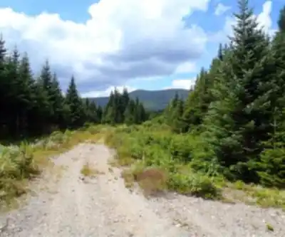
To access the hiking trails, you can start from the Caribou Valley Road (CVR) trailhead. The CVR is a rough, unpaved road, so a high-clearance vehicle is recommended. The trailhead is located near the end of Caribou Valley Road, which can be accessed from Route 27. There are no official parking lots, but hikers typically park along the roadside. Please ensure your vehicle is parked safely and does not obstruct traffic or private property.
When?
How much?
- Hiking shoes Essential
- Layered clothing Essential
- Rain jacket Essential
- Trekking poles
- Headlamp
FAQ - Frequently asked questions
Everything you need to knowThe Essential Hiking Checklist
Everything you need for your next hike. Bilingual, printable, 1 page.
Download the free checklistSimilar hikes nearby
Discover other trails you might enjoy
Long Mountain
Western Mountains
Pleasant Mountain
Western Mountains
Crocker Mountain
Western Mountains
Tumbledown Mountain
Western Mountains
Witt's End Trail
Western Mountains
Bear Mountain Inn + Barn Maine
Western Mountains
Hiking near North Conway
0 trails to explore ~123 km away
We work hard to provide the most up-to-date and error-free data possible. If something seems incorrect, let us know! Your contribution helps the whole community.
Hikers' opinions