

Ready to explore Old Speck, Maine? Here's everything you need to know before you go!
Discover the trail
Trail description
Description
Old Speck Mountain stands as Maine's fourth-highest peak at 4,170 feet, commanding the northeastern end of the Mahoosuc Range in Oxford County. This imposing summit marks the northeasternmost extension of the White Mountains, rising dramatically above Grafton Notch State Park and offering some of the most challenging and rewarding hiking in western Maine.
The mountain's position creates a natural fortress between major landmarks. To the southwest, Mahoosuc Arm extends the ridgeline toward New Hampshire, while across Grafton Notch to the northeast, Baldpate Mountain's distinctive twin peaks provide a striking contrast. This geographic setting places Old Speck at the heart of one of Maine's most rugged wilderness corridors, where the Appalachian Trail threads through some of its most demanding terrain.
The Hiking Experience
The primary route to Old Speck's summit follows the Old Speck Trail, a 9.7-kilometer round-trip journey that gains 1,268 meters of elevation over steep, unforgiving terrain. Plan for 6 to 8 hours to complete this very hard-rated hike, which demands serious preparation and fitness. The trail wastes little time with gentle warm-up sections, instead launching directly into sustained steep climbs that will test your endurance from the start.
Rocky terrain dominates much of the ascent, requiring careful foot placement and occasional scrambling over granite slabs and boulder fields. The trail cuts through dense mixed forest for most of the climb, providing shade but limited views until you near the summit. Weather exposure becomes a significant factor in the upper elevations, where wind and sudden weather changes can create challenging conditions even on days that start clear.
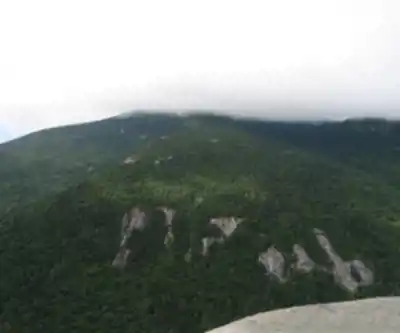
The wooded summit itself offers limited views, but this apparent disappointment quickly transforms into one of Maine's most spectacular vantage points. A fire tower, no longer used for fire spotting, now serves as an observation platform that elevates hikers above the treeline. Climbing the tower reveals a complete 360-degree panorama encompassing the rolling peaks of western Maine, the distant Presidential Range in New Hampshire, and the vast forests that stretch toward Canada.
Trail Connections and Extended Options
Old Speck sits just 0.3 miles east of the Appalachian Trail, connected by a short but steep side trail that adds the summit to the AT's epic journey from Georgia to Maine. This connection opens possibilities for extended backpacking adventures along the Mahoosuc Range, widely considered one of the AT's most challenging sections.
For those seeking a true wilderness experience, Speck Pond lies 1.1 miles down the Appalachian Trail from near the summit, perched at 3,400 feet elevation. This high-altitude pond creates an almost alpine environment rare in Maine, surrounded by stunted spruce and offering a dramatic contrast to the dense forests below. The pond receives annual stocking with brook trout, creating exceptional fly fishing opportunities for anglers willing to carry their gear up the mountain.
Natural Features and Watershed
Old Speck's massive bulk feeds multiple watersheds that eventually flow into the Androscoggin River system. The mountain's north and east faces drain into the Bear River, while the southeast and southwest slopes send water tumbling down through the Bull Branch of Goose Eye Brook to the Sunday River. The northwest face contributes to Silver Stream, which joins Chickwolnepy Stream before reaching the Androscoggin. This water eventually reaches Merrymeeting Bay and the Kennebec River estuary before flowing into the Gulf of Maine.
These drainage patterns create diverse ecosystems across the mountain's slopes, from rushing mountain streams in the lower elevations to the unique high-altitude environment near the summit. The varied terrain supports different forest communities, with hardwood forests giving way to mixed growth and eventually to the stunted spruce and fir that characterize Maine's highest peaks.
Practical Considerations
The trailhead sits within Grafton Notch State Park, providing reliable access and parking facilities. However, the mountain's elevation and northern location create a shorter hiking season than lower peaks, with snow often persisting into May and returning by October. Summer conditions can still include sudden weather changes, making layers and rain gear essential even on promising days.
The trail's difficulty rating reflects not just the elevation gain and distance, but the sustained nature of the climbing and the technical terrain. Proper hiking boots with ankle support become crucial on the rocky sections, and trekking poles can provide valuable stability and reduce stress on knees during the long descent.
Water sources exist along the route, but treating any natural water remains essential. The exposed nature of the upper mountain makes this hike unsuitable for inexperienced hikers or those uncomfortable with challenging terrain and potential weather exposure.
Old Speck represents Maine mountain hiking at its most demanding and rewarding, combining significant physical challenge with some of the state's finest summit views. The mountain's position at the intersection of major ranges and its role in the greater Appalachian Trail system make it a destination that serious hikers return to repeatedly, finding new appreciation for its rugged character and commanding presence in Maine's western mountains.
Ready to go?
Everything you need to know before you goStarting Point
The start of the trails at the old speck, maine can be accessed by taking Route 26 north from Fryeburg, Maine. The trailhead is located on the left side of the road approximately 2.5 miles from the center of Fryeburg.
When?
How much?
- Hiking shoes Essential
- Layered clothing Essential
- Rain jacket Essential
- Trekking poles
- Headlamp
FAQ - Frequently asked questions
Everything you need to knowThe Essential Hiking Checklist
Everything you need for your next hike. Bilingual, printable, 1 page.
Download the free checklistSimilar hikes nearby
Discover other trails you might enjoy

Long Mountain
Western Mountains
Pleasant Mountain
Western Mountains
Crocker Mountain
Western Mountains
Tumbledown Mountain
Western Mountains
Witt's End Trail
Western Mountains
Bear Mountain Inn + Barn Maine
Western Mountains
Hiking near North Conway
0 trails to explore ~59 km away
We work hard to provide the most up-to-date and error-free data possible. If something seems incorrect, let us know! Your contribution helps the whole community.
Hikers' opinions