

Ready to explore Tumbledown Mountain, Maine? Here's everything you need to know before you go!
Discover the trail
Trail description
Description
Tumbledown Mountain rises prominently in Franklin County, Maine, establishing itself as one of western Maine's most rewarding hiking destinations. Located in unincorporated Township 6, north of Weld, this mountain draws hikers from across New England with its distinctive alpine pond and varied trail system that accommodates different skill levels and preferences.
The mountain's defining feature is the stunning alpine pond situated just below the summit, known locally as both Crater Lake and Tumbledown Pond. This pristine body of water creates an unexpected alpine environment in Maine's western mountains, offering hikers a dramatic reward for their climb. The pond's crystal-clear waters reflect the surrounding granite cliffs and provide a perfect spot for rest and photography before the final push to the summit.
Trail System and Hiking Experience
Tumbledown Mountain offers a 9-kilometer hiking experience with 939 meters of elevation gain, typically requiring 3 to 5 hours to complete depending on your pace and chosen route. The moderate difficulty rating reflects the substantial elevation gain and some technical sections, but the well-maintained trails make this mountain accessible to hikers with reasonable fitness levels.
The trail system provides multiple route options, allowing hikers to customize their experience based on skill level and time constraints. All trailheads are located on Byron Road, making access straightforward for visitors. The varying difficulty levels mean that less experienced hikers can still enjoy portions of the mountain while more adventurous climbers can tackle the full ascent to the summit.
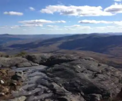
As you climb, the terrain transitions from typical Maine forest through increasingly rocky sections. The approach to the alpine pond involves some scrambling over granite slabs and boulders, adding an element of adventure without requiring technical climbing skills. The final approach to the summit offers panoramic views that extend across western Maine's mountainous landscape, and on exceptionally clear days, visibility can reach as far as Canada.
Summit Experience and Views
The summit of Tumbledown Mountain provides expansive panoramic views of the surrounding countryside that justify every step of the climb. The elevated perspective showcases the rolling hills and forests that define this region of Maine, creating a sense of accomplishment and connection with the landscape. The summit area offers ample space for groups to spread out, enjoy lunch, and take in the scenery without feeling crowded.
Campers will find suitable space near the summit for overnight stays, with several established fire pits available for use. This overnight option transforms the Tumbledown experience into a more immersive wilderness adventure, allowing visitors to witness sunrise and sunset from this elevated perch. The camping opportunity adds significant value for those seeking to extend their mountain experience beyond a day hike.
Wildlife and Natural Environment
The diverse ecosystem around Tumbledown Mountain supports a variety of wildlife that hikers may encounter throughout their journey. Deer are commonly spotted along the trails, particularly during early morning and evening hours. Moose frequent the area, especially near water sources and in the lower elevations where they browse on aquatic vegetation and young trees.
Black bears also inhabit this region, making proper food storage essential for anyone camping overnight. While bear encounters are relatively rare, hikers should remain aware of their surroundings and follow standard bear safety protocols. The presence of these larger mammals indicates the healthy, undisturbed nature of the ecosystem surrounding Tumbledown Mountain.
The transition from dense forest to alpine environment as you gain elevation provides opportunities to observe different plant communities and their associated wildlife. The area around the alpine pond supports unique vegetation adapted to the harsher conditions found at higher elevations, creating an interesting contrast with the lush forest environment found on the lower slopes.
Nearby Attractions
Coos Canyon enhances the appeal of visiting Tumbledown Mountain by providing an excellent swimming opportunity during summer months. This mountain stream creates natural pools and swimming holes that offer refreshing relief after a challenging hike. The canyon's clear, cold water provides the perfect complement to a day spent climbing in the Maine mountains.
The proximity of Coos Canyon to Tumbledown Mountain makes it easy to combine both destinations in a single trip, creating a full day of outdoor recreation. Many hikers plan their visits to include both the mountain climb and a cooling swim, making the Byron Road area a comprehensive outdoor recreation destination.
Planning Your Visit
The location in unincorporated Township 6, north of Weld, places Tumbledown Mountain in a relatively remote setting that contributes to its appeal as an escape from urban environments. The well-maintained trails ensure that this remoteness doesn't compromise safety or accessibility, striking an ideal balance between wilderness experience and practical hiking conditions.
The mountain's popularity among hikers means that weekend visits, particularly during peak foliage season and summer months, can result in busier trails and parking areas. Early morning starts not only help avoid crowds but also provide the best opportunities for wildlife viewing and optimal lighting conditions for photography.
Weather conditions can change rapidly at higher elevations, making appropriate gear essential regardless of the season. The exposed sections near the summit and around the alpine pond can be significantly cooler and windier than conditions at the trailhead, requiring hikers to pack additional layers even during summer visits.
Ready to go?
Everything you need to know before you goStarting Point
The trails at the tumbledown mountain, maine in Maine can be accessed from the parking lot on the south side of the mountain.
When?
How much?
- Hiking shoes Essential
- Layered clothing Essential
- Rain jacket Essential
- Trekking poles
- Headlamp
FAQ - Frequently asked questions
Everything you need to knowThe Essential Hiking Checklist
Everything you need for your next hike. Bilingual, printable, 1 page.
Download the free checklistSimilar hikes nearby
Discover other trails you might enjoy

Long Mountain
Western Mountains
Pleasant Mountain
Western Mountains
Crocker Mountain
Western Mountains
Tumbledown Mountain
Western Mountains
Witt's End Trail
Western Mountains
Bear Mountain Inn + Barn Maine
Western Mountains
Hiking near North Conway
0 trails to explore ~90 km away
We work hard to provide the most up-to-date and error-free data possible. If something seems incorrect, let us know! Your contribution helps the whole community.
Hikers' opinions