

Ready to explore Sams Point Summit, New York? Here's everything you need to know before you go!
Discover the trail
Trail description
Description
Sam's Point Summit sits at the top of the Shawangunk Ridge in New York's Hudson Valley, and it earns its reputation as one of the most distinctive hikes in the region. This isn't just another summit walk — the combination of exposed cliff-top views, rare ecosystems, and geological curiosities makes it genuinely unlike most trails you'll find in the Northeast.
The summit is located within Sam's Point Preserve, which is part of the Minnewaska State Park Preserve system. The area protects a remarkable concentration of natural features: dwarf pitch pine barrens that give the ridge an almost otherworldly feel, naturally formed ice caves tucked between massive boulders, and cascading waterfalls that cut through the rocky terrain. Each of these adds something different to the experience, and together they make the hike feel like more than just a climb to a viewpoint.
Trail Stats
The full loop system covers 13.5 kilometers with 698 meters of elevation gain, rated very hard with an estimated time of 4 hours 30 minutes. That's a meaningful day out — not a casual stroll. The elevation gain is sustained enough that you'll feel it, and the rocky terrain demands attention throughout. Budget your time accordingly and don't underestimate the return leg.
What the Terrain Is Actually Like
The trail starts in forested sections before opening up onto the more exposed rocky areas that define the Shawangunks. As you gain elevation, the forest gives way to the dwarf pitch pine barrens — a rare ecosystem in New York State where stunted pines and hardy shrubs cling to thin soil over bare rock. The effect is striking: the trees are small, the sky opens up, and the landscape takes on an almost alpine quality despite the elevation. It's one of those places that genuinely surprises people who haven't been before.
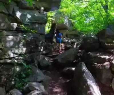
The rock underfoot is the same white conglomerate that makes the Shawangunks famous among climbers — grippy when dry, but demanding respect when wet. The footing requires focus, especially on steeper sections and around the ice caves where moisture lingers.
Ice Caves
The ice caves are one of the trail's signature features and worth slowing down for. These aren't caves in the traditional sense — they're crevices and chambers formed between massive boulders, where cold air gets trapped and temperatures stay noticeably lower even on hot summer days. The temperature drop when you step into the shaded recesses is immediate and welcome. Getting through them involves some basic scrambling and careful footing, but nothing that requires technical skills. Most hikers with reasonable mobility can navigate them without issue.
Views and Payoff
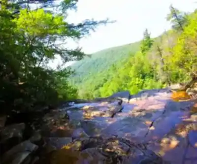
The summit's exposed rock ledges deliver panoramic views across the Hudson Valley and toward the Catskill Mountains. The landscape spreads out in layers — forested ridges, distant peaks, and the broad valley floor below. These viewpoints come at multiple points along the route, not just at the top, so there's a natural rhythm of climbing and pausing that breaks up the effort.
Verkeerderkill Falls and Extended Options
For hikers looking to push further, the Verkeerderkill Falls Trail branches off from the main route and leads to one of the highest waterfalls in the Shawangunks. The falls are most impressive during spring snowmelt or after significant rainfall, when the volume of water creates a dramatic drop down the cliff face. Adding this section increases both distance and total elevation change, so factor that in if you're already working through the main loop.
The trail network also passes through varied habitats that support good birdwatching. The ridge thermals attract raptors, while the forested sections hold a range of woodland species. Early morning tends to be the most productive time for wildlife observation.
Getting There
Sam's Point Summit is accessible from nearby towns including Ellenville and Kerhonkson. The preserve draws visitors from across the Hudson Valley and the broader Northeast. Lake Minnewaska is also in the area, which makes it possible to pair a summit hike with time near the water — whether that's a picnic or getting out on the lake itself.
What to Bring
- Water: The exposed sections of trail offer little shade, and the elevation gain will push your hydration needs higher than you might expect.
- Food: At 4.5 hours, this is a full half-day effort. Bring enough to fuel the return trip.
- Footwear: Hiking boots or sturdy trail shoes with solid traction. The rocky terrain and moisture near the ice caves and waterfalls make grip essential.
- Layers: The exposed ridge can be significantly cooler and windier than the surrounding valleys. Check the forecast and pack accordingly even on mild days.
The preserve operates under Leave No Trace principles, which matters here more than in many places. The dwarf pitch pine barrens and other ecosystems on the ridge are fragile — stay on designated trails, pack out everything you bring in, and give wildlife space.
Recommended gear for this trail


Ready to go?
Everything you need to know before you goStarting Point
To access the hiking trails, head to the main parking area located at 400 Sams Point Road, Cragsmoor, NY 12420. This is the primary trailhead for the area.
When?
How much?
- Hiking shoes Essential
- → Salomon Elixir Tour Mid WP · 203.38 $
- Layered clothing Essential
- Rain jacket Essential
- Trekking poles
- → Black Diamond Trail Ergo Cork · 69.99 $
- Headlamp
- → Petzl Actik Core 625 · 103.95 $
FAQ - Frequently asked questions
Everything you need to knowThe Essential Hiking Checklist
Everything you need for your next hike. Bilingual, printable, 1 page.
Download the free checklistSimilar hikes nearby
Discover other trails you might enjoy

West Mountain
Hudson Valley
Witches Hole
Hudson Valley
Appalachian Trail
Hudson Valley
Little Dam Lake
Hudson Valley
Raven's Rock
Hudson Valley
Sterling Forest Fire Tower
Hudson Valley
Hiking near Poughkeepsie
0 trails to explore ~36 km away
We work hard to provide the most up-to-date and error-free data possible. If something seems incorrect, let us know! Your contribution helps the whole community.
Hikers' opinions