

Ready to explore Schunnemunk Mountain, New York? Here's everything you need to know before you go!
Discover the trail
Trail description
Description
Schunnemunk Mountain rises 1,664 feet above the Hudson Valley as Orange County's highest peak, offering hikers a distinctive experience just an hour from New York City. This mountain stands apart from other Hudson Valley destinations thanks to its unique conglomerate rock formations and glacial erratics—massive boulders deposited by ancient ice sheets that create an almost otherworldly landscape along the ridgeline.
The mountain's accessibility via MTA services from the Metropolitan Transportation Authority makes it a practical choice for day trips, while its varied terrain and multiple trail options provide enough challenge and scenery to satisfy both casual walkers and serious hikers. Unlike many peaks in the region, Schunnemunk's long, relatively flat ridgeline allows for extended ridge walking with consistent views rather than a single summit experience.
Trail Options and Terrain
The Long Path serves as the mountain's primary hiking route, stretching over 9 miles across the ridgeline and offering the most comprehensive experience of what Schunnemunk has to offer. This trail takes you through several distinct environments: dense hardwood forests on the lower slopes, open rock slabs and conglomerate outcroppings along the ridge, and occasional meadow-like clearings that provide unexpected variety in the landscape.
The Jessup Trail along Taylor Road provides an alternative approach to the mountain, offering a different perspective on the terrain and connecting to the broader trail network. Both routes involve steady climbs through mixed forest before emerging onto the characteristic rock formations that define Schunnemunk's character.
The conglomerate rock ridges create a hiking surface unlike most other mountains in the Hudson Valley. These ancient rock formations, composed of rounded pebbles cemented together over millions of years, provide excellent traction underfoot while creating dramatic visual interest. The glacial erratics scattered across the landscape add to the geological story, some standing as tall as small buildings and providing natural landmarks along the route.
Views and Scenic Highlights
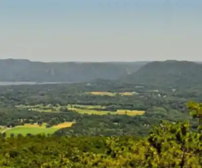
The Western Ridge delivers some of the most impressive vistas in the Hudson Valley, with panoramic views stretching across the Hudson River and surrounding peaks. From various points along the ridgeline, hikers can see the Manhattan skyline on clear days, the Catskill Mountains to the north, and the rolling hills of New Jersey to the south. These viewpoints are distributed throughout the hike rather than concentrated at a single summit, making the entire ridge walk rewarding.
The mountain's elevation and position provide particularly striking views of the surrounding valleys, where the patchwork of farms, forests, and small communities creates a quintessential Hudson Valley landscape. The contrast between the wild, rocky ridgeline and the pastoral valleys below emphasizes the region's unique character.
Wildlife and Natural Features
Schunnemunk Mountain supports diverse ecosystems that change with elevation and season. White-tailed deer are commonly spotted throughout the forested areas, particularly during early morning and late afternoon hikes. The varied habitats attract numerous songbird species, with their calls providing a constant soundtrack to the hiking experience.
Spring brings vibrant wildflower displays to the lower elevations and forest clearings, while summer offers full canopy cover that provides welcome shade during the steeper sections of trail. The diverse plant communities range from typical northeastern hardwood forests dominated by oak and maple to specialized communities adapted to the thin soils and exposed conditions of the ridge.
Seasonal Considerations
Each season transforms the Schunnemunk experience significantly. Autumn turns the mountain into one of the Hudson Valley's premier foliage destinations, with the elevated viewpoints providing expansive views of the fall color display across multiple valleys. The contrast between the colorful deciduous forests and the gray conglomerate rock creates particularly photogenic conditions.
Winter opens up snowshoeing opportunities along the same trails used for hiking, though the exposed ridgeline can be challenging in severe weather. The bare trees of winter actually improve some viewpoints by removing the leaf cover that can obstruct views during the growing season.
Spring and summer offer the most comfortable hiking conditions, though summer can be warm on the exposed rock sections of the ridge. The varied terrain provides options for finding shade or sun depending on conditions and personal preference.
Nearby Attractions and Trail Connections
Schunnemunk Mountain serves as an anchor point for exploring the broader Hudson Valley trail network. Sterling Forest State Park lies nearby, offering additional hiking opportunities and different terrain types for those looking to extend their outdoor experience. The Barton Swamp Trails provide a contrasting wetland environment that showcases different aspects of the region's natural diversity.
The Dark Hollow Trail offers a more intimate forest experience for those seeking a quieter alternative to the main ridge routes. The Highlands Trail connects Schunnemunk to the larger network of paths throughout the Hudson Highlands, making it possible to plan multi-day adventures or simply explore different approaches to familiar destinations.
Salisbury Mills provides convenient access to these various trail systems and serves as a logical base for exploring the area. The proximity to major routes makes it practical to combine Schunnemunk with visits to other Hudson Valley attractions or to make it part of a longer regional exploration.
Practical Planning Information
The mountain's location near major highways and accessibility via MTA services makes trip planning straightforward, though hikers should pack plenty of water since reliable water sources are limited along the ridge. Sturdy hiking boots are essential for navigating the conglomerate rock surfaces safely, particularly when wet conditions can make the rock slippery.
A camera proves worthwhile for capturing both the expansive views and the unique geological features that make Schunnemunk distinctive. The combination of scenic vistas and interesting rock formations provides photographic opportunities throughout the hike rather than just at specific viewpoints.
Recommended gear for this trail


Ready to go?
Everything you need to know before you goStarting Point
To access the hiking trails, you can start at several trailheads. One option is the Otterkill Road Trailhead, located at 339 Otterkill Road, Cornwall, NY 12518. Another starting point is the Taylor Road Trailhead, found at 300 Taylor Road, Mountainville, NY 10953. Both locations provide parking facilities for hikers.
When?
How much?
- Hiking shoes Essential
- → Salomon Elixir Tour Mid WP · 203.38 $
- Layered clothing Essential
- Rain jacket Essential
- Trekking poles
- → Black Diamond Trail Ergo Cork · 69.99 $
- Headlamp
- → Petzl Actik Core 625 · 103.95 $
FAQ - Frequently asked questions
Everything you need to knowThe Essential Hiking Checklist
Everything you need for your next hike. Bilingual, printable, 1 page.
Download the free checklistSimilar hikes nearby
Discover other trails you might enjoy

West Mountain
Hudson Valley
Witches Hole
Hudson Valley
Appalachian Trail
Hudson Valley
Little Dam Lake
Hudson Valley
Raven's Rock
Hudson Valley
Sterling Forest Fire Tower
Hudson Valley
Hiking near Poughkeepsie
0 trails to explore ~38 km away
We work hard to provide the most up-to-date and error-free data possible. If something seems incorrect, let us know! Your contribution helps the whole community.
Hikers' opinions