

Ready to explore Black Mountain - Sntsk'il'ntən Regional Park? Here's everything you need to know before you go!
Discover the trail


Trail description
Description
Black Mountain presents an interesting case of multiple outdoor destinations sharing the same name in British Columbia. The most accessible option is a 3.7-kilometer lightly trafficked loop trail near Texada Island that showcases beautiful wildflowers and welcomes hikers of all skill levels. This trail remains open year-round and provides a manageable introduction to the island's natural beauty.
For those seeking the Texada Island experience, this fantastic hike delivers impressive views eastward toward the Coastal Mountains on the mainland. The trailhead access requires some navigation: head down Hydro East Road from either the High or Central Road, then take the first left off the logging road. You'll find parking at two convenient locations along the left side of the road - at the Music Farm crossroads and at the adjacent gravel pit.
Black Mountain Regional Park Near Kelowna
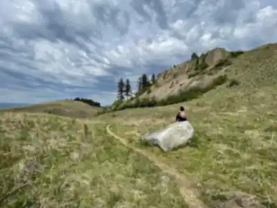
The more substantial hiking destination is Black Mountain Regional Park, located near Kelowna in the heart of the Okanagan Valley. This 640-hectare hiking area offers a completely different experience from its island namesake, featuring extensive trail networks that wind through the region's characteristic grasslands and semi-arid terrain.
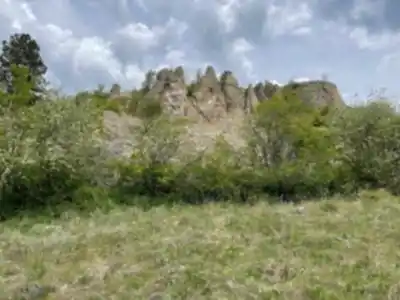
The park's trail system provides hikers with unobstructed views of Okanagan Lake stretching below, while the landscape itself tells the geological story of the valley through unusual rock formations known as hoodoos. These distinctive pillars and spires create a dramatic backdrop that sets this hiking area apart from the dense forests typical of much of British Columbia.
Timing your visit to Black Mountain Regional Park can dramatically enhance the experience. Spring visitors are rewarded with the valley's spectacular wildflower season, when entire hillsides burst into color with dense patches of golden balsamroot sunflowers. These bright yellow blooms create a stunning contrast against the dry grasslands and provide exceptional photography opportunities.
The park serves as an excellent location for observing Okanagan wildlife in their natural habitat. Hikers commonly encounter deer browsing in the grasslands, while the more observant may spot coyotes moving through the terrain. The area also supports snake populations adapted to the dry climate, adding an element of wildlife diversity that reflects the unique ecosystem of the southern interior.
The Suburban Viewpoint
One of the most unusual aspects of the Black Mountain experience near Kelowna is the Black Mountain Viewpoint, which occupies an unexpected location within what can only be described as suburbia. Surrounded by residential developments, this small natural area provides a surprising pocket of wilderness access with stunning panoramic vistas.
The viewpoint truly comes alive at sunset, when the changing light transforms the entire valley below. As golden light washes across the landscape, hikers are treated to a breathtaking panorama encompassing both Kelowna's urban sprawl and the natural beauty of Okanagan Lake. This combination of accessibility and dramatic views makes it an ideal way to end a day of outdoor exploration.
The contrast between the developed surroundings and the wild vistas creates a unique hiking experience that reflects the Okanagan's character as a region where urban development and natural beauty coexist in close proximity. Despite its suburban setting, the viewpoint maintains its appeal as a legitimate outdoor destination.
Trail Characteristics and Terrain
The various Black Mountain locations offer distinctly different hiking experiences. The Texada Island loop provides a more traditional coastal British Columbia environment, with the trail winding through terrain that supports diverse wildflower populations. The relatively short distance and easy difficulty rating make it accessible for families and those looking for a moderate outdoor activity without significant physical demands.
In contrast, the Kelowna-area Black Mountain Regional Park presents the characteristic landscape of the Thompson Okanagan region. The trails here traverse rolling grasslands and semi-arid slopes that require different preparation than coastal hikes. The open terrain means greater sun exposure, making proper sun protection and adequate water essential, particularly during summer months.
The park's extensive trail network allows for various route combinations, enabling hikers to customize their experience based on available time and energy levels. Some paths focus on the geological features and hoodoo formations, while others prioritize lake views and wildflower areas.
Seasonal Considerations
Both Black Mountain locations offer year-round access, but the optimal experience varies significantly with the seasons. The Texada Island trail maintains relatively consistent conditions throughout the year, though spring and early summer provide the best wildflower displays.
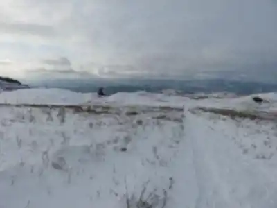
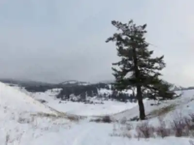
For Black Mountain Regional Park near Kelowna, spring represents the premium season when wildflowers reach their peak and temperatures remain comfortable for extended hiking. Summer brings intense heat that can make midday hiking challenging, though early morning and evening excursions remain pleasant. Fall offers comfortable temperatures and clear views, while winter provides a different perspective on the landscape, though hikers should be prepared for potentially icy conditions on exposed slopes.
The variety of activities available at both locations extends beyond traditional hiking, reflecting the diverse recreational opportunities that make these destinations appealing to different types of outdoor enthusiasts throughout the changing seasons.
Recommended gear for this trail


Ready to go?
Everything you need to know before you goStarting Point
The trail begins along an ancient mossy road that gradually rises in height. Turn left at the T-intersection. After 5 minutes, look for a cairn on the right that marks the beginning of a rib boned track through the low underbrush forest. The route will gradually ascend until ending with a brief hard climb up and over a ridge. A difficult struggle up through exposed limestone cliffs stumped ancient trees, and Manzanita shrubs leads from there. The finest vantage position is directly below the somewhat flat plateau, a little lower than the path height. Beautiful views of the Coastal Mountains.
When?
How much?
- Hiking shoes Essential
- → Salomon Elixir Tour Mid WP · 203.38 $
- Layered clothing Essential
- Rain jacket Essential
- Trekking poles
- → Black Diamond Trail Ergo Cork · 69.99 $
- Headlamp
- → Petzl Actik Core 625 · 103.95 $
FAQ - Frequently asked questions
Everything you need to knowThe Essential Hiking Checklist
Everything you need for your next hike. Bilingual, printable, 1 page.
Download the free checklistSimilar hikes nearby
Discover other trails you might enjoy

Big White Ski Resort
Thompson Okanagan

Cougar Canyon
Thompson Okanagan
Spectrum Lake
Thompson Okanagan
Mahood Lake
Thompson Okanagan
Kentucky Lake
Thompson Okanagan
Frosty Mountain
Thompson Okanagan
Hiking near Kelowna
45 trails to explore ~13 km away
We work hard to provide the most up-to-date and error-free data possible. If something seems incorrect, let us know! Your contribution helps the whole community.
Hikers' opinions