Hiking Belcarra Regional Park - panoramic view
--°C
Loading...
See forecast →

Hiking in Belcarra Regional Park: trails, map and practical info

Vancouver Coast Mountains • British Columbia

4.6 Appreciated by 30 hikers
François Dumaine
By François DumaineContributor since 2013Updated 23/06/2026
Difficulty
Easy
Distance
11 km
Elevation
549 ft
Duration
3h00
Max altitude
1,050 ft

Escape to the Vancouver Coast Mountains with an 11 km easy hike through coastal forest and inlet views. This 3-hour day trip blends lush woodland with saltwater scenery and frequent viewpoints—perfect for wildlife spotting and photography without leaving the Lower Mainland.

Recommended for :
Beginners

Ready to explore Belcarra Regional Park? Here's everything you need to know before you go!

Discover the trail

5 community photos

Trail description

What makes this park special

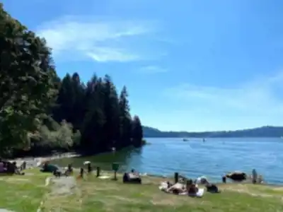
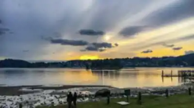
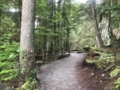
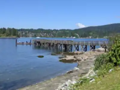
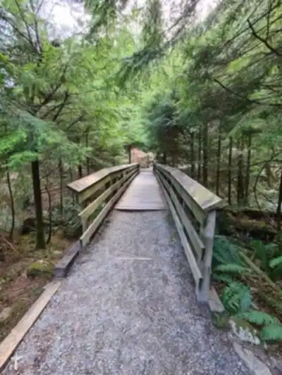
The magic of Belcarra lies in how it combines different coastal ecosystems in one manageable location. You'll move between towering Douglas fir and cedar forests where the air stays cool and still, then emerge onto rocky shorelines and open viewpoints where the scenery expands dramatically. The park is located on Burrard Inlet with views across the waterways toward Indian Arm, creating a landscape where water is always nearby, whether you can see it or just sense its presence through the trees.

This isn't a destination built around a single dramatic viewpoint or landmark. Instead, the experience unfolds gradually as you walk—forest textures shifting with the light, glimpses of water appearing between branches, and that constant interplay between enclosed woodland and open inlet views that defines the Coast Mountains character.

Recommended gear for this trail

LGPO Pick
Elixir Tour Mid WP
Salomon
Elixir Tour Mid WP
4.5 (2847 reviews)
Waterproof mid-height boot ideal for rocky terrain
203.38 $
See price
Daylite Plus 20L
Osprey
Daylite Plus 20L
4.7 (3215 reviews)
Lightweight and versatile for day hikes
109.99 $
See price
Most Popular
Wide Mouth 1L
Nalgene
Wide Mouth 1L
4.8 (12540 reviews)
Unbreakable and BPA-free — a hiking essential
23.11 $
See price
Best Value
Trail Ergo Cork
Black Diamond
Trail Ergo Cork
4.4 (1456 reviews)
Comfortable cork grip for long ascents
69.99 $
See price
Actik Core 625
Petzl
Actik Core 625
4.6 (1893 reviews)
USB rechargeable with 600 lumens for early starts
103.95 $
See price
Affiliate links — LGPO may earn a commission at no extra cost to you.

Ready to go?

Everything you need to know before you go

Where?

Address
2375 Bedwell Bay Rd, Belcarra, BC V3H 4S3, Canada
GPS coordinates
49.3122006, -122.9247353
Phone
(604) 520-6442

Starting Point

The trails at the belcarra regional park in British Columbia can be accessed from the parking lot off Bedwell Bay Road.

When?

Opening hours
Monday: 7:00 AM – 5:00 PM
Tuesday: 7:00 AM – 5:00 PM
Wednesday: 7:00 AM – 5:00 PM
Thursday: 7:00 AM – 5:00 PM
Friday: 7:00 AM – 5:00 PM
Saturday: 7:00 AM – 5:00 PM
Sunday: 7:00 AM – 5:00 PM
Varies by season
Best season
Fall
Spectacular colors
Best time
Early morning
Less crowded
Weather (next days)
Loading

How much?

Entry fees
Adult
Not available
Child
What to bring?
Gear
Download the PDF checklist
Water & food
2L minimum
No water point on the trail
Bring energy snacks for a 4h+ hike
Good to know
Park rules
No dogs
Safety
Download the GPX before you go
Limited cellular coverage on the trail
Slippery after rain
Be careful on rocky sections
In an emergency
Emergency
911
Parking GPS
49.3122006, -122.9247353
Center
(604) 520-6442

Hikers' opinions

4.6
10 Reviews
M
Marcus
Dec 8, 2025
Beautiful coastal park with well-maintained trail system covering the full 11km distance. The mossy old-growth forest sections are absolutely stunning, and the rocky shoreline views make it worthwhile. Parking fills up quickly on weekends so arrive before 10am. The 90m elevation gain is gentle enough for families but provides nice variety through the terrain.
M
Michael
Nov 18, 2025
Completed the full 11km route in about 2.5 hours at a brisk pace, though most hikers should budget 3-4 hours for the complete experience. The trail navigation can be confusing initially as the main parking area requires entering through the regional park entrance rather than following typical trailhead signage. Paid parking only throughout the area.
S
Sarah
Oct 22, 2025
Lovely park with diverse activities from hiking to kayaking. The Jug Island trail is particularly scenic, winding through gorgeous mature forest to reach a rocky beach with mountain views. Trail starts wide and graveled but becomes more rugged halfway through. Parking fees apply and spots are limited, so timing your visit is crucial for a good experience.
D
David
Sep 15, 2025
Exceptional natural beauty with incredible Pacific Northwest forest diversity throughout the 11km trail network. The ferns, mosses, and towering trees create an almost magical atmosphere that makes this one of the most special places I've visited. Easy difficulty level makes it accessible while still providing a solid 3-hour outdoor experience.
J
Jennifer
Jul 3, 2025
Great family destination with excellent facilities including restrooms, picnic areas, and kayak rentals. The trails are well-marked and offer beautiful views around the islands. However, be aware that park staff may ask visitors to leave earlier than expected, even before dark. Low tide can make waterfront access muddy, so check conditions beforehand.

FAQ - Frequently asked questions

Everything you need to know
Easy
549.00 m
1050.00 m
Monday: 7:00 AM – 5:00 PM
Tuesday: 7:00 AM – 5:00 PM
Wednesday: 7:00 AM – 5:00 PM
Thursday: 7:00 AM – 5:00 PM
Friday: 7:00 AM – 5:00 PM
Saturday: 7:00 AM – 5:00 PM
Sunday: 7:00 AM – 5:00 PM
3h00
No
No
Yes, Belcarra Regional Park is classified as an easy trail, making it well-suited for beginners and hikers of various experience levels. With only 90.1 meters of elevation gain over 11 km, the trail provides a gentle introduction to hiking without overly challenging terrain.
Didn't find your answer?
Free 1 pages

The Essential Hiking Checklist

Everything you need for your next hike. Bilingual, printable, 1 page.

Download the free checklist
Top 10 best hiking in Vancouver Coast Mountains
Our ranking based on hiker reviews

Hiking near Vancouver

235 trails to explore ~15 km away

View trails
Did you spot an error?

We work hard to provide the most up-to-date and error-free data possible. If something seems incorrect, let us know!

Update : June 2026