

Ready to explore Brae Island Regional Park? Here's everything you need to know before you go!
Discover the trail
Trail description
Description
Tucked along the Fraser River in the Vancouver Coast Mountains, Brae Island Regional Park delivers a surprisingly rich outdoor experience just minutes from urban life. This 2.5-kilometer network of riverside trails offers the perfect antidote to crowded mountain destinations, combining gentle forest paths with excellent water access in a setting that feels genuinely wild despite its accessibility. The park excels at providing that elusive balance between convenience and nature immersion that makes it invaluable for regular outdoor enthusiasts and occasional adventurers alike.
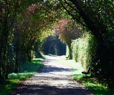
What sets Brae Island apart from other regional parks is its dual personality. The interior trails wind through mature forest that creates an almost cathedral-like atmosphere, while the riverside sections open up to sweeping Fraser River views backed by distant mountains. This contrast gives hikers a sense of variety and discovery that's often missing from shorter urban trails, making the 45-minute loop feel more substantial than its modest distance suggests.
Trail Experience and Terrain
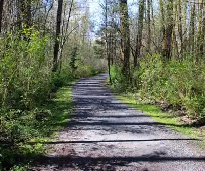
The park's trail system revolves around two main routes that can be combined into various loops depending on your time and interests. The Tavistock Trail forms the heart of the network, threading through dense stands of cottonwood, maple, and cedar that create a genuine forest experience. The soft dirt surface feels pleasant underfoot and accommodates everything from running shoes to hiking boots, while the minimal 10 meters of elevation gain keeps the focus on enjoying the surroundings rather than working up a sweat.
Walking the Tavistock Trail feels like stepping into a different world as the canopy filters sunlight into dappled patterns on the forest floor. The path meanders naturally through the island's interior, following the contours of the land rather than taking the most direct route. This design creates a sense of exploration and discovery as each bend reveals new perspectives on the towering trees and understory vegetation.
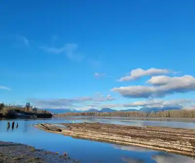
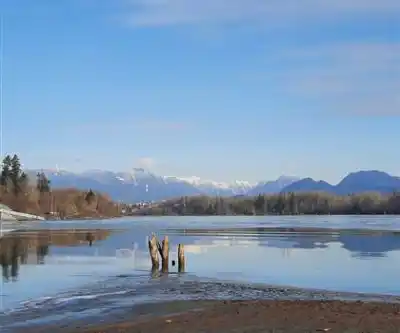
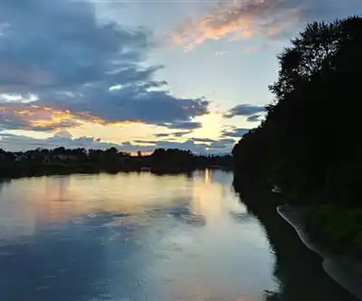
The Fort-to-Fort Trail extends the experience beyond the park boundaries while delivering the best river views available. This route alternates between packed earth and well-maintained gravel sections, with clear marking throughout that makes navigation effortless. The real payoff comes at several vantage points where the trail opens up to reveal the Fraser River's broad channels and the mountain backdrop that defines this region. Interpretive signs along the way provide historical context about early British Columbia, though most visitors find themselves drawn more to the sweeping water views than the educational content.
Both trails interconnect at multiple points, giving you the flexibility to customize your route length and create different loop combinations. This design works particularly well for families with varying energy levels or groups where some members want a shorter walk while others prefer to explore more extensively.
Wildlife and Seasonal Highlights
The park's position at the meeting point of river and forest ecosystems creates wildlife viewing opportunities that rival much more remote destinations. Bald eagles are the star attraction, frequently visible in the tall cottonwoods along the riverbank where they hunt during salmon runs. These magnificent birds provide excellent photography opportunities, especially for visitors equipped with telephoto lenses who can capture them in their natural fishing behavior.
Great blue herons add another dimension to the wildlife experience, wading patiently in shallow areas near shore where their hunting techniques create compelling viewing. The birds' stillness and sudden strikes at fish make for dramatic moments that highlight the active ecosystem thriving along the Fraser River.
Beyond the headline species, the diverse habitat supports an impressive variety of smaller wildlife often overlooked in more dramatic mountain settings. Woodpeckers work the mature trees with their distinctive drumming, while various songbirds inhabit the understory layers. During spring and fall migrations, the park serves as a crucial stopover point for waterfowl traveling the Pacific Flyway, creating temporary but spectacular birding opportunities.
Timing your visit for early morning or late afternoon typically yields the best wildlife sightings when animal activity peaks and lighting conditions favor both observation and photography. The seasonal changes in the Fraser River itself also affect wildlife behavior, making repeat visits throughout the year worthwhile for serious nature enthusiasts.
Water Activities and River Access
The Fraser River frontage transforms Brae Island from a simple walking destination into a genuine multi-activity outdoor experience. Multiple launch points provide excellent access for canoeing and kayaking, with the broad, relatively calm sections near the park suitable for intermediate paddlers. The river remains a major waterway with significant currents and boat traffic, so beginners should exercise appropriate caution and consider guided trips for their first Fraser River experiences.
Several informal beach areas make water access easy whether you're launching watercraft or simply want to enjoy riverside relaxation. These spots work well for families with children who want to explore the water's edge or for anyone seeking a peaceful place to sit and watch the river flow by.
Fishing opportunities exist along the riverbank, with access to both main channel and backwater areas that hold different species depending on the season. Success rates vary considerably with water conditions and fish runs, but the setting makes even slow fishing days enjoyable. Anyone planning to fish should verify current regulations and licensing requirements, as Fraser River fishing rules can be complex and change seasonally based on conservation needs.
The designated cycling trails accommodate bikes, though the relatively short network makes this more suitable as part of a longer regional ride rather than a primary cycling destination. The flat terrain and scenic river views create pleasant easy riding, particularly appealing to families with children or casual cyclists looking for a scenic, low-stress route.
Facilities and Access
Multiple picnic areas throughout the park provide tables and basic amenities strategically located to maximize river views while maintaining shelter under the forest canopy. The combination of open grassy areas and shaded sections accommodates different preferences for sun exposure and works well for groups of various sizes. Some picnic spots sit directly along the riverbank where the sound of flowing water creates natural background ambiance that enhances the outdoor dining experience.
Well-maintained facilities include washrooms and garbage collection, though visitors should bring their own water and food as no concessions operate within the park. The parking areas accommodate a reasonable number of vehicles, but weekend visits during peak season may require arriving earlier in the day to secure convenient spots near the trailheads.
The park's location within easy driving distance of Vancouver provides genuine nature immersion without requiring significant travel time or mountain driving skills. The access road remains paved and suitable for standard vehicles year-round, making it accessible even during winter months when higher elevation destinations become challenging to reach. This year-round accessibility, combined with the gentle terrain and substantial facilities, makes Brae Island particularly valuable for urban residents seeking regular outdoor exercise or nature connection without major time commitments.
Recommended gear for this trail


Ready to go?
Everything you need to know before you goStarting Point
The brae island regional park is located in Richmond, British Columbia. To get to the start of the trails, take Highway 99 south to the Steveston Highway exit. Turn left on Steveston Highway and continue for about 2 kilometers until you reach Bayview Road. Turn right on Bayview Road and continue for about 1 kilometer until you reach the park entrance.
When?
How much?
- Hiking shoes Essential
- → Salomon Elixir Tour Mid WP · 203.38 $
- Layered clothing Essential
- Rain jacket Essential
- Trekking poles
- → Black Diamond Trail Ergo Cork · 69.99 $
- Headlamp
- → Petzl Actik Core 625 · 103.95 $
FAQ - Frequently asked questions
Everything you need to knowThe Essential Hiking Checklist
Everything you need for your next hike. Bilingual, printable, 1 page.
Download the free checklistSimilar hikes nearby
Discover other trails you might enjoy

Bridle Path
Vancouver Coast Mountains
Flora Lake
Vancouver Coast Mountains

Alouette Mountain
Vancouver Coast Mountains

Williamson Lake
Vancouver Coast Mountains
Brandywine Mountain
Vancouver Coast Mountains

Coliseum Mountain
Vancouver Coast Mountains
Hiking near Vancouver
235 trails to explore ~42 km away
We work hard to provide the most up-to-date and error-free data possible. If something seems incorrect, let us know! Your contribution helps the whole community.
Hikers' opinions