

Ready to explore Buntzen Lake Trail? Here's everything you need to know before you go!
Discover the trail
Trail description
Description
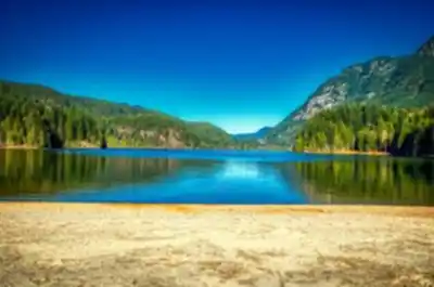
The Buntzen Lake Trail offers one of the most accessible yet rewarding hiking experiences in the Vancouver Coast Mountains. This 8-kilometer loop circles the pristine waters of Buntzen Lake, a stunning reservoir nestled among towering coastal peaks and dense old-growth forest. With only 100 meters of elevation gain spread across the entire route, the trail welcomes hikers of all abilities while delivering consistently spectacular mountain and lake views that rival much more challenging destinations.
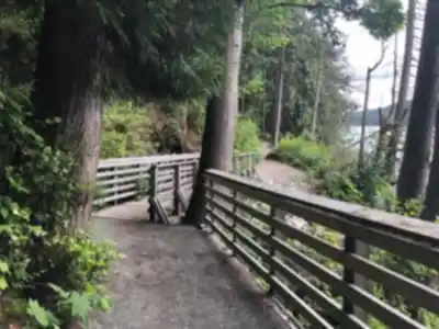
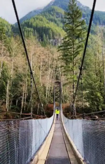
What makes this trail exceptional is how it transforms a relatively easy walk into a genuinely immersive wilderness experience. Rather than following a flat, monotonous shoreline path, the route weaves through diverse forest ecosystems and climbs to strategic viewpoints that showcase the lake from multiple perspectives. The well-maintained trail surface handles the gentle elevation changes smoothly, with sturdy wooden bridges spanning creek crossings and thoughtfully placed rest areas that encourage you to pause and soak in the scenery.
Trail Experience and Terrain
Most hikers tackle the loop clockwise, starting near the lake's southern end where you're immediately enveloped by the cathedral-like atmosphere of coastal rainforest. Massive Douglas firs and western red cedars tower overhead, their canopy filtering sunlight into dappled patterns on the forest floor. The understory shifts constantly as you progress, from lush fern grottos to sections dominated by salmonberry and huckleberry bushes that provide seasonal treats for both wildlife and hikers.
The eastern shore section feels intimate and enclosed, with the trail winding between moss-covered boulders and crossing several babbling creeks that feed the lake. Here, glimpses of the crystal-clear water appear regularly through the trees, creating anticipation for the more open views ahead. The path maintains a gentle grade throughout this section, making conversation easy and allowing you to fully appreciate the rich forest sounds and scents.
As you round the lake's northern end, the forest opens dramatically, revealing expansive panoramas across the water toward the surrounding Coast Mountain peaks. This transition marks one of the trail's most striking features – how quickly the intimate forest experience gives way to grand alpine vistas. The western shore provides the most spectacular scenery, with several elevated viewpoints offering unobstructed views of the entire lake basin framed by rugged mountain ridges.
The return journey along the lake's western and southern shores follows different terrain entirely, passing through areas where the forest floor is carpeted in emerald moss and fallen logs create natural sculptures. This section includes the trail's most significant climbs, but the steady, well-graded ascents feel manageable even for novice hikers. The varied terrain keeps the 8-kilometer distance engaging throughout, with new perspectives and forest environments appearing around each bend.
Wildlife and Natural Features
The diverse ecosystem surrounding Buntzen Lake supports an impressive array of wildlife year-round. Bird enthusiasts will find plenty to observe, from the chattering Steller's jays and common ravens that frequent the forest canopy to the occasional bald eagle soaring high above the lake. The water itself attracts various waterfowl, particularly during spring and fall migrations when ducks and geese use the lake as a crucial stopover point.
Black bears are present throughout the area, especially during late summer when the trail's abundant berry bushes produce their fruit. While encounters remain relatively uncommon due to the trail's popularity, staying alert and making noise in dense forest sections is always wise. More commonly spotted wildlife includes busy chipmunks and Douglas squirrels, while patient hikers might catch glimpses of black-tailed deer in the quieter morning and evening hours.
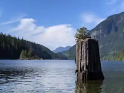
The lake itself serves as the trail's centerpiece, its remarkably clear waters revealing submerged logs and rocky bottom features that create an almost tropical appearance on sunny days. Several small islands dot the surface, providing nesting habitat for various bird species and adding visual depth to the mountain reflections. The surrounding peaks, including the distinctive ridgelines that define this part of the Coast Mountains, create a dramatic backdrop that shifts in character as light and weather conditions change throughout the day.
Seasonal Highlights
Each season transforms the Buntzen Lake Trail into a distinctly different experience. Spring brings an explosion of wildflowers throughout the forest understory, with trilliums, bleeding hearts, and various native species creating colorful displays against the rich green backdrop. The numerous waterfalls and creeks that feed the lake run at their most impressive volumes during this season, fed by snowmelt from the higher elevations surrounding the basin.
Summer provides ideal hiking conditions, with warm temperatures perfect for extended breaks at the scenic viewpoints. The long daylight hours allow for leisurely exploration and photography, while the lake reaches its warmest temperatures – though swimming remains refreshingly cool due to the elevation and depth. This season also offers the most reliable weather for enjoying the trail's full 8-kilometer length without concern for changing conditions.
Fall transforms the entire loop into a showcase of autumn colors, as deciduous trees and shrubs turn brilliant shades of yellow, orange, and red against the evergreen forest backdrop. The crisp fall air often provides the year's clearest mountain views, with enhanced visibility revealing distant peaks and ridgelines that may be hazy during summer months. This season also brings the most dramatic light conditions for photography, with the lower sun angle creating striking contrasts across the water and forest.
Winter hiking offers a peaceful retreat into a snow-dusted landscape, though conditions vary significantly with recent weather and elevation. The trail's relatively low elevation means the route often remains accessible even when higher trails are snow-covered, creating beautiful contrasts between the dark lake water and frost-covered forest. The 2.5-hour estimated hiking time may extend during winter conditions, but the reduced crowds and serene atmosphere provide their own rewards.
Access and Practical Information
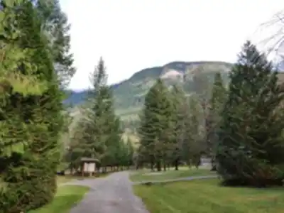
The trailhead features excellent facilities that make trip planning straightforward. A substantial parking area accommodates the trail's well-deserved popularity, though early arrival on weekends and holidays ensures the best spot selection. Clean restroom facilities are available at the parking area, along with detailed trail maps and current condition updates that help with route planning.
Several designated picnic areas along the 8-kilometer route provide perfect spots for breaks and meals, with tables and benches positioned to maximize the lake and mountain views. These areas also serve as logical turnaround points for families with young children or anyone preferring a shorter outing than the full loop.
Clear trail markers throughout the route help with navigation and progress tracking, while the trail's popularity means assistance is typically nearby if needed. The well-maintained path surface handles the 100 meters of elevation gain smoothly, though sturdy hiking footwear provides the best traction on roots and rocks, particularly during wet conditions when surfaces can become slippery.
Recommended gear for this trail


Ready to go?
Everything you need to know before you goStarting Point
The buntzen lake trail is located in Anmore, British Columbia. To get to the start of the trails, take exit #8 from Highway 1 and head east on Sunnyside Road. The trailhead will be on your left.
When?
How much?
- Hiking shoes Essential
- → Salomon Elixir Tour Mid WP · 203.38 $
- Layered clothing Essential
- Rain jacket Essential
- Trekking poles
- → Black Diamond Trail Ergo Cork · 69.99 $
- Headlamp
- → Petzl Actik Core 625 · 103.95 $
FAQ - Frequently asked questions
Everything you need to knowThe Essential Hiking Checklist
Everything you need for your next hike. Bilingual, printable, 1 page.
Download the free checklistSimilar hikes nearby
Discover other trails you might enjoy

Bridle Path
Vancouver Coast Mountains
Flora Lake
Vancouver Coast Mountains

Alouette Mountain
Vancouver Coast Mountains
Brandywine Mountain
Vancouver Coast Mountains

Williamson Lake
Vancouver Coast Mountains

Coliseum Mountain
Vancouver Coast Mountains
Hiking near Vancouver
235 trails to explore ~20 km away
We work hard to provide the most up-to-date and error-free data possible. If something seems incorrect, let us know! Your contribution helps the whole community.
Hikers' opinions