


Ready to explore Cascade Falls Regional Park? Here's everything you need to know before you go!
Discover the trail
Trail description
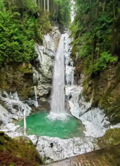
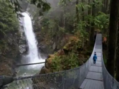
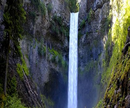
Cascade Falls Regional Park is one of the Fraser Valley's most rewarding easy-access destinations in British Columbia. The park's main draw is its namesake waterfall — a dramatic multi-tiered cascade that drops more than 100 feet over a series of rocky cliffs. It's the kind of waterfall that stops you in your tracks, especially during spring snowmelt or after a stretch of heavy Pacific Northwest rain when the volume is at its peak. The falls are fed by mountain runoff, so flow is strongest from April through June, though the site is worth visiting year-round.
Standing at the base viewpoint, you get the full picture: water thundering down the rock face, mist rising from the pools below, and on sunny days, small rainbows forming in the spray. The sound alone is worth the walk — it fills the gorge completely and makes the rest of the world feel very far away.
The Trails
The trail network here covers around 15 kilometres in total, with a modest 100 metres of elevation gain spread across the system. That makes this an easy destination suitable for families, casual hikers, and anyone looking for a solid half-day outing — plan for roughly 4 hours 30 minutes if you want to explore the full network rather than just heading straight to the falls and back.
The terrain is typical of the Fraser Valley's mixed coastal forest: Douglas fir, western red cedar, and bigleaf maple overhead, with salmonberry, sword ferns, and moss-covered logs filling in the understory. The trails are well-maintained and clearly signed, with distances and difficulty levels marked at key junctions. Most of the paths are wide enough that hikers and mountain bikers can pass each other comfortably — the trail system is shared-use, with designated routes for each.
Multiple viewpoints of the falls are accessible from different sections of the trail network. The lower viewpoint gives you the classic straight-on perspective of the full cascade. Upper trails shift the angle entirely, offering glimpses of the creek as it approaches the cliff edge before the drop. The rocky terrain immediately around the falls deserves some attention underfoot — it gets slick from the constant mist and rain, so footwear with decent grip matters here.
Beyond the waterfall corridor, the trails push out into the broader forest, moving between riparian zones along the creek and drier slopes on the hillsides. These sections reveal a more varied ecosystem and are worth exploring if you have the time and want to stretch the outing.
Wildlife and Natural Features
Deer are a common sight throughout the park, particularly in the early morning and at dusk when they move into more open areas. Black bears are present in the region, though regular day-use traffic keeps encounters infrequent. Overhead, eagles work the thermals above the forest canopy. Along the creek and in the surrounding trees, you'll find woodpeckers, songbirds, and occasionally river otters in the lower reaches of the waterway.
The geology here is part of what makes the falls so striking. The creek has carved a narrow gorge into the bedrock over thousands of years, cutting through layers of sedimentary rock to create the dramatic vertical drop. The rock face is heavily colonized by moss and lichen, thriving in the near-constant moisture from the spray. In winter, ice formations build up along the cliff, adding a completely different visual character to the site.
Facilities
The park is well set up for families and groups. Picnic areas are scattered throughout, with tables and some covered shelters — useful given how often it rains in this part of British Columbia. A playground near the main parking area gives kids somewhere to burn energy before or after the hike. Bike racks are available at key points along the trail system.
There is no admission fee to enter the park, and it's open year-round. Parking is available at the main entrance, but fills up fast on weekends and through the summer. Arriving early or visiting on a weekday makes a noticeable difference both for parking and for the overall experience on the trail.
Getting There and Timing Your Visit
Cascade Falls Regional Park sits within easy driving distance of the Vancouver metropolitan area, making it a natural choice for a day trip out of the city. The park's relatively low elevation means snow rarely closes access to the main trails, so winter visits are genuinely viable — just expect muddy conditions and bring waterproof footwear with solid traction.
Spring is the most dramatic time to visit if the waterfall is your primary goal, with peak flow running through April, May, and June. Summer brings the most foot traffic but also the most reliable weather for exploring the full trail network. Fall offers quieter trails and the added colour of the bigleaf maples turning, while winter strips things back to the essentials — rushing water, bare branches, and the occasional ice-fringed cliff face.
Recommended gear for this trail
As an Amazon Associate I earn from qualifying purchases.


Ready to go?
Everything you need to know before you goStarting Point
The cascade falls regional park is located in the town of Hope, British Columbia. To get to the park, take exit 135 from Highway 1 and head east on Water Avenue. The park will be on your left.
When?
How much?
As an Amazon Associate I earn from qualifying purchases.
Affiliate links — LGPO may earn a commission at no extra cost to you.
- Hiking shoes Essential
- → Salomon Elixir Tour Mid WP · 203.38 $
- Layered clothing Essential
- Rain jacket Essential
- Trekking poles
- → Black Diamond Trail Ergo Cork · 69.99 $
- Headlamp
- → Petzl Actik Core 625 · 103.95 $
FAQ - Frequently asked questions
Everything you need to know
25 hikes under 2 hours from Montreal
Distance, elevation, parking and season for each one. The ones we go back to ourselves.
Get the guideSimilar hikes nearby
Discover other trails you might enjoy
Bridle Path
Vancouver Coast Mountains
Flora Lake
Vancouver Coast Mountains

Alouette Mountain
Vancouver Coast Mountains
Williamson Lake
Vancouver Coast Mountains
Brandywine Mountain
Vancouver Coast Mountains

Coliseum Mountain
Vancouver Coast Mountains
Hiking near Vancouver
235 trails to explore ~66 km away
We work hard to provide the most up-to-date and error-free data possible. If something seems incorrect, let us know! Your contribution helps the whole community.
Hikers' opinions
Be the first to review!
No hiker has shared their experience yet. Share your impressions and help other hikers!