

Ready to explore Cates Park? Here's everything you need to know before you go!
Discover the trail
Trail description
Cates Park sits on the shores of Burrard Inlet in North Vancouver, offering hikers a unique blend of waterfront trails and forested paths just 20 minutes from downtown Vancouver. This waterfront park features a well-maintained 3.7-kilometer loop trail that is generally considered easy and takes approximately 49 minutes to complete on average.
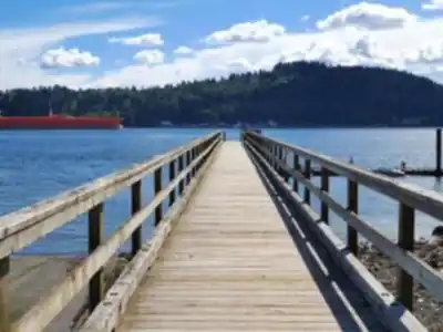
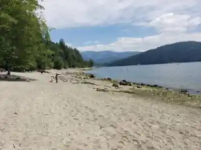
The trail system is particularly popular for birding, mountain biking, and trail running, with a diverse mix of terrain. The lower waterfront section follows a wide, well-maintained path that hugs Burrard Inlet's edge, perfect for families or anyone seeking an easy walk with constant water views. Here, the trail surface is mostly packed gravel and boardwalk sections, making it accessible even after rain. The paths wind through coastal forest featuring Douglas fir and western red cedar.
What sets Cates Park apart from other Vancouver-area walks is its dramatic contrast between environments within such a short distance. You'll start among driftwood and tidal pools, listening to waves against the shore, then move through towering forest. The relatively flat terrain makes it an excellent destination for hikers of all abilities, including families and those new to hiking.
Trail Experience and Terrain
The hiking experience at Cates Park unfolds through distinct phases that showcase the diversity packed into this waterfront location. Beginning at the shoreline, you'll traverse smooth boardwalks and gravel paths where the sound of lapping waves provides a constant soundtrack. The terrain here is forgiving, with minimal elevation change and wide, stable surfaces that accommodate hikers of all abilities.
As the trail system leads you through the park, the paths navigate through the coastal forest. The trail surface is primarily packed gravel and earth with some natural sections featuring roots and rocks that require normal attention to foot placement. The overall moderate grade and well-maintained conditions make this accessible year-round.
Views and Wildlife
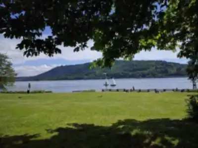
The park's positioning on Burrard Inlet provides expansive water views toward the North Shore mountains, with Mount Seymour and the peaks around Deep Cove forming a dramatic backdrop. From the trail sections, you'll catch glimpses of downtown Vancouver's skyline across the water.
Wildlife viewing opportunities are genuinely impressive for such an accessible location. Bald eagles frequently soar overhead and often perch in the large trees near the water, especially during salmon runs. Harbor seals are common in the inlet waters. The forested sections host typical coastal birds including Steller's jays, varied thrushes, and several woodpecker species. Early morning or late afternoon visits increase your chances of wildlife encounters.
Cultural Significance
Cates Park's ancestral name is Whey-ah-Wichen, a Tsleil-Waututh word meaning 'faces the wind.' The park sits on traditional Tsleil-Waututh territory with thousands of years of Indigenous presence. Throughout the park, interpretive signs share the history and cultural significance of this land. The signs are thoughtfully placed at natural rest stops along the trails, offering opportunities to learn while taking in the surroundings that have sustained communities for millennia.
Trail Conditions and Navigation
The trail system is well-marked with clear signage at major junctions. The main loop is straightforward to follow. Trail maintenance is generally excellent, with regular clearing of fallen branches and seasonal repairs to boardwalk sections. The trail is open year-round and is beautiful to visit anytime. Dogs are welcome, but must be on a lead.
Facilities and Amenities
Cates Park offers amenities suitable for extended visits or family outings. Several picnic areas with tables are scattered throughout the park, including some with covered shelters for rainy day use. Parking is free and generally adequate, with additional roadside parking available along the park's perimeter. The area is also accessible by public transit with a short walk from nearby bus stops.
Best Times to Visit
Cates Park rewards visitors year-round. Spring brings wildflower blooms and increased bird activity. Summer provides warm weather for extended visits, though this is also the busiest season. Fall offers spectacular foliage and clearer mountain views, while winter visits reveal the park's structure and often provide dramatic storm-watching opportunities from the protected shoreline areas. Early morning visits any time of year tend to be quieter and offer the best wildlife viewing.
Recommended gear for this trail


Ready to go?
Everything you need to know before you goStarting Point
The cates park is located in North Vancouver, British Columbia. To get to the start of the trails, take the exit for Capilano Road on Highway 1 and drive north for about 5 kilometers. The park will be on your left.
When?
Tuesday: 6:00 AM – 10:00 PM
Wednesday: 6:00 AM – 10:00 PM
Thursday: 6:00 AM – 10:00 PM
Friday: 6:00 AM – 10:00 PM
Saturday: 6:00 AM – 10:00 PM
Sunday: 6:00 AM – 10:00 PM
How much?
- Hiking shoes Essential
- → Salomon Elixir Tour Mid WP · 203.38 $
- Layered clothing Essential
- Rain jacket Essential
- Trekking poles
- → Black Diamond Trail Ergo Cork · 69.99 $
- Headlamp
- → Petzl Actik Core 625 · 103.95 $
FAQ - Frequently asked questions
Everything you need to knowTuesday: 6:00 AM – 10:00 PM
Wednesday: 6:00 AM – 10:00 PM
Thursday: 6:00 AM – 10:00 PM
Friday: 6:00 AM – 10:00 PM
Saturday: 6:00 AM – 10:00 PM
Sunday: 6:00 AM – 10:00 PM
The Essential Hiking Checklist
Everything you need for your next hike. Bilingual, printable, 1 page.
Download the free checklistSimilar hikes nearby
Discover other trails you might enjoy

Bridle Path
Vancouver Coast Mountains
Flora Lake
Vancouver Coast Mountains

Alouette Mountain
Vancouver Coast Mountains

Williamson Lake
Vancouver Coast Mountains
Brandywine Mountain
Vancouver Coast Mountains

Coliseum Mountain
Vancouver Coast Mountains
Hiking near Vancouver
235 trails to explore ~12 km away
We work hard to provide the most up-to-date and error-free data possible. If something seems incorrect, let us know! Your contribution helps the whole community.
Hikers' opinions