

Ready to explore Elfin Lakes? Here's everything you need to know before you go!
Discover the trail
Trail description
Description
Elfin Lakes is one of those destinations that earns its reputation every single time. Sitting deep in the Vancouver Coast Mountains and accessed from the Diamond Head trailhead just outside Squamish, it delivers genuine alpine wilderness without requiring a week-long expedition. Whether you're tackling it as a long day hike or stretching it into an overnight, the payoff at the end is hard to argue with.
The round trip covers 22 kilometers with 600 meters of elevation gain, and most hikers budget around 7.5 hours for the full day version. That works out to a sustained but manageable climb — moderate in difficulty, but long enough that you'll want to take it seriously.
The Trail Experience
The route starts at the Diamond Head trailhead and wastes no time getting into the mountains. The lower section moves through dense coastal forest — Douglas fir, western hemlock, the kind of old growth that keeps things cool and shaded even on a hot July afternoon. The climbing here is steady and consistent, giving you time to find your rhythm before the terrain opens up.
Red Heather Meadows is the first major milestone, and it earns its reputation as a rest stop. The trail levels out here, the trees pull back, and suddenly you've got real mountain views in front of you. In peak summer, the meadows are thick with wildflowers — a genuine highlight that's easy to underestimate until you're standing in the middle of it.
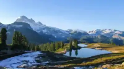
Past Red Heather, the landscape shifts again. The subalpine gives way to true alpine terrain, rocky and exposed, with the kind of wide-open views that remind you why you came. The final push to the lakes crosses ground where the weather can turn fast and the wind has nothing to hide behind. That openness is part of what makes it feel like a real mountain destination rather than just a long forest walk.
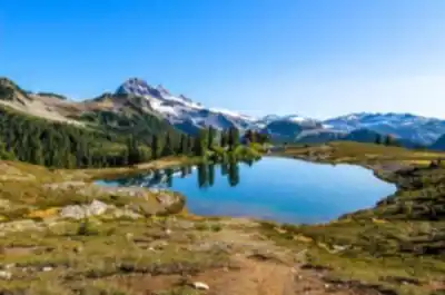
The two lakes themselves sit in a natural cirque — a basin carved out by glaciers over thousands of years. On a calm day, the larger lake mirrors the surrounding peaks almost perfectly. It's the kind of scene that stops people mid-stride.
Wildlife and Geology
The elevation range along this trail means you're moving through multiple ecosystems, and the wildlife reflects that. Black bears are a regular presence, especially in late summer when the berry patches in the meadows are productive. Higher up, hoary marmots are practically residents — you'll hear their sharp whistles bouncing off the rocks well before you spot them.
The geology here tells a clear story of glacial history. The cirque lakes, the sharp ridgelines, the steep headwalls — all of it was shaped by ice. Later in the season, permanent snowfields and small glaciers are still visible on the higher surrounding peaks, a reminder that this landscape is still very much in conversation with its glacial past.
Camping and Overnight Options
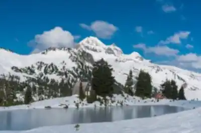
The designated camping area near the lakes is what turns this into a full mountain experience. There's a basic shelter on site that provides weather protection and a natural gathering spot for overnight visitors. Pit toilets are available, but otherwise facilities are intentionally minimal — this is a wilderness camping area, not a campground with amenities.
Camping permits are required and must be reserved in advance through BC Parks. During summer weekends and holidays, spots go fast, so booking early isn't optional — it's just how it works. The campsite is positioned close enough to the lakes for easy access while keeping foot traffic away from the most sensitive shoreline areas.
Staying overnight changes the experience significantly. The early morning light on the peaks, the quiet after day hikers have cleared out, the alpenglow at sunset — these are things you simply can't get on a day trip, no matter how early you start.
Seasonal Conditions
Summer is the most straightforward time to visit. Trails are clear, temperatures are reasonable, and the alpine meadows hit peak bloom through July and August. The lakes are cold but swimmable for those inclined. Weather is most stable during this window, which matters when you're planning an overnight.
Snow lingers well into late spring, and early summer visitors should expect patches on the trail, particularly in shaded sections and around the lakes. Check current conditions with BC Parks before heading out — the difference between a clear trail and a snow slog can be significant depending on the year.
Fall brings a short but spectacular window in late September and early October when the alpine larches turn gold. It's worth timing a visit around this if you can, though weather becomes less predictable and you should be prepared for early winter conditions at elevation.
Winter transforms the area into backcountry ski and snowshoe terrain. The trail is still accessible but requires proper winter travel skills and equipment. The reward is a level of solitude that's impossible to find here in summer.
What to Know Before You Go
The 600 meters of elevation gain over 11 kilometers one way is a sustained climb that rewards a steady pace over a fast one. The trail surface is well-maintained, which helps, but the overall distance means nutrition and hydration need to be planned properly — not just a water bottle and a granola bar.
Alpine weather moves fast. Even on clear summer days, temperatures at the lakes drop noticeably compared to the trailhead, and afternoon thunderstorms are common. Layered clothing and a waterproof shell are standard kit, not optional extras. Overnight visitors should plan for temperatures near freezing even in midsummer.
Check the BC Parks website for current trail conditions, permit availability, and any seasonal closures before your trip — conditions at Elfin Lakes can vary significantly depending on snowpack and recent weather.
Recommended gear for this trail


Ready to go?
Everything you need to know before you goStarting Point
The elfin lakes trailhead is located in Garibaldi Provincial Park, about 90 minutes north of Vancouver. To get there, take Highway 99 to Squamish and then follow the signs to Garibaldi Provincial Park.
When?
How much?
- Hiking shoes Essential
- → Salomon Elixir Tour Mid WP · 203.38 $
- Layered clothing Essential
- Rain jacket Essential
- Trekking poles
- → Black Diamond Trail Ergo Cork · 69.99 $
- Headlamp
- → Petzl Actik Core 625 · 103.95 $
FAQ - Frequently asked questions
Everything you need to knowThe Essential Hiking Checklist
Everything you need for your next hike. Bilingual, printable, 1 page.
Download the free checklistSimilar hikes nearby
Discover other trails you might enjoy

Bridle Path
Vancouver Coast Mountains
Flora Lake
Vancouver Coast Mountains

Alouette Mountain
Vancouver Coast Mountains

Williamson Lake
Vancouver Coast Mountains
Brandywine Mountain
Vancouver Coast Mountains

Coliseum Mountain
Vancouver Coast Mountains
Hiking near Squamish
211 trails to explore ~15 km away
We work hard to provide the most up-to-date and error-free data possible. If something seems incorrect, let us know! Your contribution helps the whole community.
Hikers' opinions