

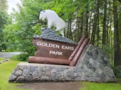
Ready to explore Golden Ears Provincial Park? Here's everything you need to know before you go!
Discover the trail
Trail description
Description
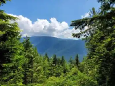
Golden Ears Provincial Park covers 62,000 hectares of rugged Coast Mountains wilderness, sitting close enough to Vancouver to make it a weekend destination but wild enough to feel genuinely remote once you're past the trailhead. The terrain here runs the full spectrum—dense old-growth valleys, rushing creek corridors, subalpine meadows, and exposed granite ridges that demand respect. It's one of those parks where you can bring the whole family on a Sunday morning walk or commit to a serious summit push that will test your fitness and your gear.
The Golden Ears Summit Trail
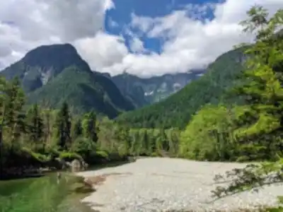
The park's signature route is the Golden Ears Summit Trail, a 24-kilometer round trip that gains 1,500 meters of elevation and takes most hikers around 10.5 hours to complete. That combination of distance, vertical gain, and technical terrain puts it firmly in the hard category—this isn't a trail to attempt casually or without preparation.
The first few kilometers lull you into a false sense of ease. The path follows alongside Alouette Creek through towering Douglas fir and western red cedar, the trail well-maintained and the grade gentle. Enjoy it while it lasts. Past that initial stretch, the climb becomes relentless, pushing steadily upward through forest that gradually thins as you gain elevation. The transition from dense coastal forest to open subalpine terrain is one of the route's most rewarding moments—suddenly the canopy opens, the views start to appear, and the air takes on that sharp alpine quality.
The final approach to the summit is where the trail earns its hard rating. Loose rock, exposed ridgelines, and sections of scrambling require careful footwork and full attention. There's no room for distraction up here. Those who make it to the top are rewarded with sweeping panoramic views across the Fraser Valley, with Mount Baker visible on clear days and the jagged North Shore peaks stretching across the horizon in both directions.
Weather monitoring is non-negotiable for this route. Conditions on the exposed upper ridges can shift dramatically even when the valley below looks perfectly clear. Afternoon thunderstorms are a real risk during summer, and temperatures can drop sharply at elevation. Start early—both to beat the heat and to give yourself a buffer before afternoon weather rolls in.
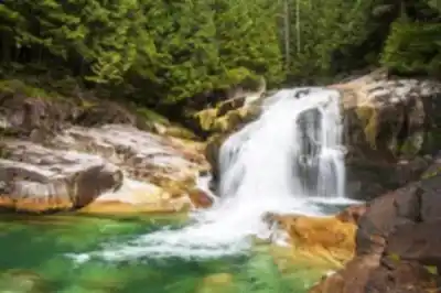
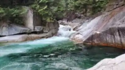
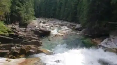
Lower Falls Trail
The Lower Falls Trail is everything the summit route isn't: gentle, accessible, and suitable for hikers of all ages and fitness levels. The path winds through some of the park's most impressive old-growth forest before arriving at a waterfall where Alouette Creek drops over granite ledges into deep pools below. The sound of rushing water follows you most of the way, and the forest itself is worth the trip even before you reach the falls.
The trees along this route are genuinely massive—cedar and fir that have been growing for centuries, creating a canopy so dense it stays cool and humid even on hot summer days. The understory is thick with ferns, salmonberry, and devil's club, and the rich smell of cedar bark and decomposing forest floor is the kind of thing that sticks with you long after you've driven home. This trail stays hikeable year-round, though winter visitors should be prepared for potentially icy sections and should wear appropriate footwear.
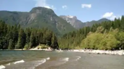
Alouette Lake and Camping
Alouette Lake sits at the recreational center of the park, its clear water reflecting the surrounding peaks on calm mornings. Swimming is popular during summer, though the lake stays cold even at the height of the season. Canoeists and kayakers can explore quieter bays and inlets away from the main beach area, and anglers target rainbow trout and kokanee salmon.
Several established campgrounds around the lake serve as base camps for multi-day trips. Sites fill quickly during peak season, and advance reservations are essential if you're planning a weekend visit. Arriving without a reservation on a summer weekend is a gamble that rarely pays off.
Wildlife
Black bears are a regular presence in the park, particularly during late summer when salmon runs draw them to the creeks and berry patches provide additional food. Deer are commonly spotted along forest edges and in meadows during early morning and evening. The bird life ranges from wrens and chickadees working through the forest understory to ravens and hawks riding thermals above the ridgelines.
The park's ecosystems shift dramatically with elevation. The lower valleys hold coastal forest with conifers some 500 years old. Higher up, the forest opens into subalpine meadows where wildflowers peak in July and August. Above treeline, the landscape becomes rocky and sparse, with hardy alpine plants clinging to whatever soil they can find between the boulders.
Planning Your Visit
Golden Ears is close enough to Vancouver that it draws serious crowds on weekends and holidays. Parking lots regularly fill by 8 AM on sunny summer days, so arriving early isn't optional if you want a spot. An early start also means cooler temperatures for the climb and better odds of clear summit views before afternoon clouds build.
Snow typically lingers on the upper sections of the Golden Ears Summit Trail well into June, and in some years the route isn't fully accessible until July. If you're planning a summit attempt in late spring, check current trail conditions before heading out. Lower elevation trails like the Lower Falls route remain accessible through the winter with appropriate footwear.
Recommended gear for this trail


Ready to go?
Everything you need to know before you goStarting Point
The easiest way to get to the start of the trails at golden ears provincial park is to take Highway 7 east from Vancouver to Maple Ridge. Once in Maple Ridge, take the Golden Ears Way exit and follow the signs to the park.
When?
Tuesday: 7:00 AM – 7:00 PM
Wednesday: 7:00 AM – 7:00 PM
Thursday: 7:00 AM – 7:00 PM
Friday: 7:00 AM – 7:00 PM
Saturday: 7:00 AM – 7:00 PM
Sunday: 7:00 AM – 7:00 PM
How much?
- Hiking shoes Essential
- → Salomon Elixir Tour Mid WP · 203.38 $
- Layered clothing Essential
- Rain jacket Essential
- Trekking poles
- → Black Diamond Trail Ergo Cork · 69.99 $
- Headlamp
- → Petzl Actik Core 625 · 103.95 $
FAQ - Frequently asked questions
Everything you need to knowTuesday: 7:00 AM – 7:00 PM
Wednesday: 7:00 AM – 7:00 PM
Thursday: 7:00 AM – 7:00 PM
Friday: 7:00 AM – 7:00 PM
Saturday: 7:00 AM – 7:00 PM
Sunday: 7:00 AM – 7:00 PM
The Essential Hiking Checklist
Everything you need for your next hike. Bilingual, printable, 1 page.
Download the free checklistSimilar hikes nearby
Discover other trails you might enjoy

Bridle Path
Vancouver Coast Mountains
Flora Lake
Vancouver Coast Mountains

Alouette Mountain
Vancouver Coast Mountains

Williamson Lake
Vancouver Coast Mountains
Brandywine Mountain
Vancouver Coast Mountains

Coliseum Mountain
Vancouver Coast Mountains
Hiking near Vancouver
235 trails to explore ~42 km away
We work hard to provide the most up-to-date and error-free data possible. If something seems incorrect, let us know! Your contribution helps the whole community.
Hikers' opinions