

Ready to explore Halfmoon Bay? Here's everything you need to know before you go!
Discover the trail
Trail description
Description
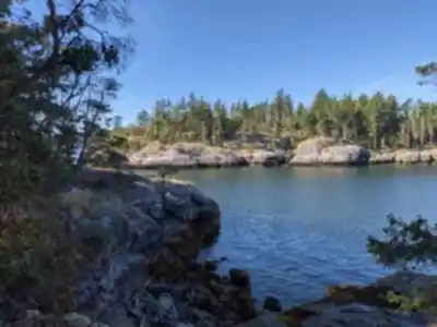
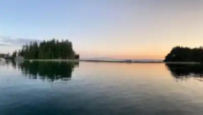
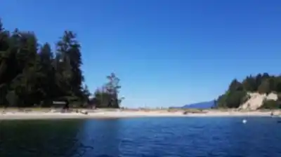
Halfmoon Bay is a small coastal community tucked along the eastern shore of its namesake bay on the Sunshine Coast of British Columbia. Surrounded by the Coast Mountains, dense old-growth forest, and a rugged shoreline, it's the kind of place that rewards hikers who are willing to venture a little off the beaten path. The area sits within the broader Vancouver Coast Mountains region and offers a mix of forest trails, ocean views, and access to the natural landscape that defines this stretch of the BC coast.
The Landscape
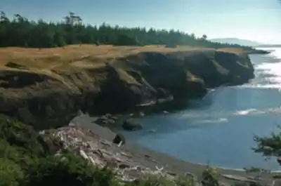
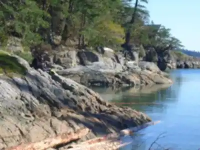
The terrain around Halfmoon Bay is shaped by the meeting of mountains and sea. The forests here are thick and coastal — expect towering conifers, mossy undergrowth, and the kind of quiet that comes from being well away from the city. The bay itself provides a scenic backdrop, and several trails in the area take advantage of the elevation change to deliver views over the water and the surrounding inlets.
With a recorded elevation gain of 300 metres, hikes in this area involve a meaningful climb — enough to get your legs working and earn the views, but manageable for hikers with a reasonable base level of fitness. The terrain transitions from coastal forest at lower elevations to more exposed ridgelines and rocky outcrops as you gain height.
What to Expect on the Trail
Trails in the Halfmoon Bay area wind through second-growth and old-growth forest, with sections that hug the coastline and others that push inland and upward into the hills. The forest floor is typically lush, with ferns, salal, and mosses covering the ground beneath a canopy of Douglas fir, western red cedar, and hemlock. On clearer days, the views from higher points stretch out over the Strait of Georgia and toward the islands beyond.
The 300-metre elevation gain means you'll encounter some steeper pitches along the way, particularly as trails climb away from the shoreline. Trail surfaces vary — some sections are well-packed dirt, while others can be rooty and uneven, especially after rain. Good footwear with solid grip is worth having here.
Getting There
Halfmoon Bay is located on the Sunshine Coast, accessible from the Lower Mainland via BC Ferries from Horseshoe Bay to Langdale, followed by a drive up Highway 101. The community sits roughly between Sechelt and Pender Harbour. If you're coming from Vancouver, factor in ferry wait times when planning your day.
Practical Notes
- Elevation gain: 300 m
- Region: Vancouver Coast Mountains, Sunshine Coast, British Columbia
- Access: Via BC Ferries (Horseshoe Bay to Langdale) and Highway 101
- Terrain: Coastal forest, mixed trail surfaces, some exposed rocky sections at elevation
- Conditions: Trails can be wet and slippery in wet weather — standard for the BC coast
Halfmoon Bay is a solid destination for hikers looking to combine a coastal setting with a genuine climb and the kind of forest scenery that British Columbia does better than almost anywhere else.
Recommended gear for this trail


Ready to go?
Everything you need to know before you goStarting Point
The halfmoon bay trails can be accessed from the town of halfmoon bay or from Highway 101. From halfmoon bay, drive north on Highway 101 for 2 km and turn left onto Roberts Creek Road. Drive for 2 km and turn right onto Park Road. The trailhead is located at the end of the road. From Highway 101, drive south on Roberts Creek Road for 2 km and turn left onto Park Road. The trailhead is located at the end of the road.
When?
How much?
- Hiking shoes Essential
- → Salomon Elixir Tour Mid WP · 203.38 $
- Layered clothing Essential
- Rain jacket Essential
- Trekking poles
- → Black Diamond Trail Ergo Cork · 69.99 $
- Headlamp
- → Petzl Actik Core 625 · 103.95 $
FAQ - Frequently asked questions
Everything you need to knowThe Essential Hiking Checklist
Everything you need for your next hike. Bilingual, printable, 1 page.
Download the free checklistSimilar hikes nearby
Discover other trails you might enjoy

Bridle Path
Vancouver Coast Mountains
Flora Lake
Vancouver Coast Mountains

Alouette Mountain
Vancouver Coast Mountains

Williamson Lake
Vancouver Coast Mountains
Brandywine Mountain
Vancouver Coast Mountains

Coliseum Mountain
Vancouver Coast Mountains
Hiking near Nanaimo
212 trails to explore ~39 km away
We work hard to provide the most up-to-date and error-free data possible. If something seems incorrect, let us know! Your contribution helps the whole community.
Hikers' opinions