

Ready to explore Joffre Lakes Provincial Park? Here's everything you need to know before you go!
Discover the trail
Trail description
Description
Joffre Lakes Provincial Park is one of those rare places where the payoff starts the moment you step out of your car. Located along Duffey Lake Road about an hour north of Whistler, this Class A provincial park delivers glacier-capped peaks and vivid turquoise lakes without demanding a multi-day commitment or technical skills. It's the kind of hike that earns its reputation honestly.
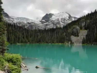
The park is built around three lakes stacked up the valley, each one more dramatic than the last. Lower Joffre Lake sits just 500 meters from the trailhead — close enough that even visitors with no hiking plans at all tend to wander over. The water is that impossible shade of blue-green that comes from glacial flour suspended in the lake, and the peaks rising above it make for an immediate, striking scene. It's one of the most photographed spots in the Coast Mountains, and for good reason.
But Lower Lake is really just the opening act. The full trail to Upper Joffre Lake covers 11 kilometers round trip with 370 meters of elevation gain, and most hikers complete it in around 3 hours and 45 minutes. Those numbers read as moderate on paper, and the lower section genuinely is — but the trail gets progressively steeper and more demanding as you push toward Middle and Upper Lake. Plan accordingly.
Trail Experience and Terrain
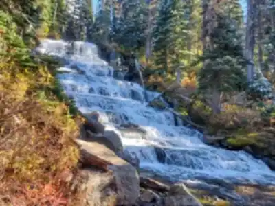
The hike starts on a well-maintained path through old-growth coastal forest. Massive cedars and hemlocks line the trail, and wooden bridges cross the cold, fast-moving creeks fed by glacial melt above. The sound of rushing water is a constant companion through this lower section, which makes for a pleasant warm-up before the climbing begins.
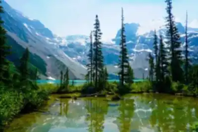
After Lower Joffre Lake, the character of the trail shifts. The forest opens up, the grade steepens, and the terrain becomes rockier and more exposed. The landscape here tells a clear geological story — U-shaped valleys carved by ancient glaciers, lateral moraines marking where ice once sat, and the fine glacial silt that gives all three lakes their signature color. It's worth slowing down to take it in.
Middle Joffre Lake rewards the extra effort with noticeably fewer people and increasingly dramatic views. The trail along this section includes some narrow, exposed ledges with real drop-offs. It's nothing that requires technical gear, but hikers who are uncomfortable with heights should know what they're getting into before committing to the upper trail.
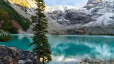
Upper Joffre Lake is the destination that makes this hike worth every step. Sitting in a deep cirque surrounded by jagged peaks and active glaciers, it's one of the most spectacular spots reachable by day hike in British Columbia. The Matier Glacier dominates the head of the valley, its blue-white ice sitting in sharp contrast against dark rock faces and the brilliant turquoise water below. On a clear day, the reflection is almost disorienting in the best possible way.
What Sets This Park Apart
Joffre Lakes sits in the Coast Mountains, not the Rockies, and that distinction matters. The peaks here rise more abruptly from the valley floor, creating a sense of vertical drama that feels compressed and intense. The maritime climate also means the lower elevations are genuinely lush — dense, mossy forest that transitions sharply into alpine rock and ice as you gain elevation. That contrast is part of what makes the hike feel so rewarding.
For photographers, the light here is worth planning around. Early morning brings mist off the lakes and soft light on the glaciated peaks. The turquoise color of the water holds up well throughout the day, but the alpine scenery at Upper Lake is particularly striking in the late afternoon when warm light hits the rock faces.
The park was established as a recreation area in 1988 and upgraded to Class A provincial park status in 1996. That designation protects the full ecosystem — from the old-growth valley forest all the way up to the active glaciers — ensuring the landscape stays intact rather than being managed primarily for resource extraction.
Planning Your Visit
Parking fills up fast, especially on summer weekends. Arriving early in the morning is the most reliable way to secure a spot and also gives you the best conditions on the trail — cooler temperatures, better light, and fewer people at the viewpoints. The parking area is directly off Duffey Lake Road, so access is straightforward once you're on the right route.
Snow lingers around the upper lakes well into summer most years. The lower trail and Lower Joffre Lake are generally accessible year-round, but the most reliable window for reaching Upper Lake is July through September. Earlier in the season, Middle Lake is often as far as conditions allow.
Beyond Upper Joffre Lake, the trail continues into more remote sections of the park for those looking to push further. The route becomes less defined past the upper lake, and the terrain is more exposed — this extension is best suited to hikers with solid navigation skills and experience in alpine environments.
Joffre Lakes Provincial Park protects a complete mountain ecosystem, from valley-bottom old-growth forest to active glaciers, and the trail through it gives hikers a genuine sense of that full range in a single day.
Recommended gear for this trail


Ready to go?
Everything you need to know before you goStarting Point
joffre lakes provincial park is located off the Sea to Sky Highway and can be reached by taking a left onto East Outlet Trail. Continue past Alexander Falls for about five kilometers until you reach Joffre Creek, where there should be ample parking on either side of the road.
When?
How much?
- Hiking shoes Essential
- → Salomon Elixir Tour Mid WP · 203.38 $
- Layered clothing Essential
- Rain jacket Essential
- Trekking poles
- → Black Diamond Trail Ergo Cork · 69.99 $
- Headlamp
- → Petzl Actik Core 625 · 103.95 $
FAQ - Frequently asked questions
Everything you need to knowThe Essential Hiking Checklist
Everything you need for your next hike. Bilingual, printable, 1 page.
Download the free checklistSimilar hikes nearby
Discover other trails you might enjoy

Bridle Path
Vancouver Coast Mountains
Flora Lake
Vancouver Coast Mountains

Alouette Mountain
Vancouver Coast Mountains

Williamson Lake
Vancouver Coast Mountains
Brandywine Mountain
Vancouver Coast Mountains

Coliseum Mountain
Vancouver Coast Mountains
Hiking near Whistler
160 trails to explore ~42 km away
We work hard to provide the most up-to-date and error-free data possible. If something seems incorrect, let us know! Your contribution helps the whole community.
Hikers' opinions