

Ready to explore Nairn Falls Provincial Park? Here's everything you need to know before you go!
Discover the trail
Trail description
Description
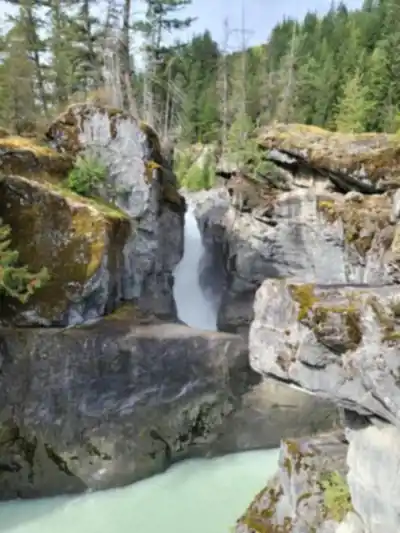
Nairn Falls Provincial Park sits 32 kilometers north of Whistler in the Vancouver Coast Mountains, offering one of the most accessible waterfall hikes in the Sea to Sky corridor. The park centers around a spectacular 60-meter cascade where the Green River plunges into a narrow gorge, creating the kind of dramatic scenery that makes this region famous among outdoor enthusiasts.
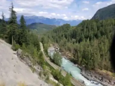
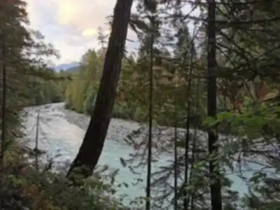
The park's location between Whistler and Pemberton puts it at the heart of some of British Columbia's most stunning mountain terrain. Dense coastal forests of towering Douglas firs and western red cedars blanket the landscape, while the rushing Green River carves its way through the valley floor. This is classic Pacific Northwest wilderness—lush, green, and alive with the constant sound of moving water.
The Nairn Falls Trail
The main Nairn Falls Trail covers 1.5 kilometers one way from the parking area to the falls viewpoint, with 60 meters of elevation gain spread throughout the route. This well-maintained path handles the moderate terrain with a series of gentle climbs and descents, making it suitable for families and hikers of all skill levels. Most visitors complete the round trip in about 45 minutes, though you'll want to budget extra time for photos and soaking in the views.
The path begins in dense forest, winding through stands of massive conifers that filter the light into soft, green-tinted beams. The trail surface varies from packed earth to wooden boardwalks in wetter sections, with occasional root systems and rocky patches that keep things interesting without being challenging. As you progress, the sound of the Green River grows stronger, and you'll catch glimpses of the rushing water through the trees.
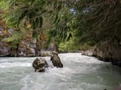
The trail follows the river's course, offering several spots where you can step closer to the water's edge and appreciate the power of this mountain waterway. These side paths lead to small clearings where the river rushes over granite boulders, creating pools and rapids that showcase the raw energy feeding the falls downstream.
Wildlife sightings are common along this route. Black bears, deer, and various bird species call this forest home, so keep your eyes open and your camera ready. The understory bursts with typical coastal forest vegetation—ferns, salmonberry, and devil's club create a lush carpet beneath the towering canopy. During late summer, you might spot ripe salmonberries along the trail edges.
The trail's final section leads to the main viewpoint, where Nairn Falls reveals itself in full dramatic glory. The Green River narrows as it approaches the precipice, then launches itself 60 meters down into a deep, rocky gorge. The force of the water has carved smooth channels in the rock face, and mist rises from the pool below, creating an almost mystical atmosphere on humid days.
The Falls Experience
The viewpoint sits at a safe distance from the falls, but close enough to feel the power of the cascading water. Multiple viewing angles let you appreciate different aspects of the waterfall—from the narrow chute where the river accelerates before its plunge, to the misty pool where it crashes into the gorge below. The rock formations surrounding the falls tell the story of thousands of years of water erosion, with smooth granite walls polished by constant spray.
Photography opportunities abound here, with the interplay of water, rock, and forest creating compelling compositions throughout the day. The falls face east, meaning morning light illuminates the cascade directly, while afternoon visits offer more dramatic side-lighting that emphasizes the texture of the rock face and the volume of mist.
Extended Hiking Options
While the Nairn Falls Trail serves as the park's main attraction, more ambitious hikers can connect to the Sea to Sky Trail system for extended adventures. These longer routes open up panoramic views of the surrounding mountains and valleys, showcasing the full scope of the Vancouver Coast Mountains' dramatic landscape. The Sea to Sky Trail network offers everything from day-long excursions to multi-day backpacking opportunities, all accessible from the park's trail system.
The connection points to these extended trails branch off from the main Nairn Falls route, giving you the flexibility to decide on the spot whether to stick with the waterfall destination or push further into the backcountry. Trail markers clearly indicate distances and difficulty levels for the various options.
Camping and Overnight Options
The park's 94 vehicle-accessible campsites transform a day trip into a proper wilderness retreat. These sites nestle among the same towering Douglas firs and cedars that line the hiking trails, providing natural privacy and shelter. The campground maintains that authentic forest atmosphere while offering the practical amenities needed for car camping.
Spending the night here means falling asleep to the distant sound of Nairn Falls and the gentle rustle of wind through the forest canopy. Morning brings the opportunity to hit the trails early, often before day-hikers arrive, giving you a more solitary experience with the waterfall and surrounding wilderness. Early morning visits also offer the best chances for wildlife encounters, as many animals are most active during these quieter hours.
Seasonal Considerations and Planning
Nairn Falls Provincial Park welcomes visitors year-round, but the experience varies dramatically with the seasons. Summer and early fall provide the most comfortable hiking conditions, with dry trails and warm temperatures that make the mist from the falls refreshing rather than chilling. This is peak season, so expect company on the trails and at the viewpoint.
Winter visits offer a completely different experience. Snow transforms the forest into a quiet, white-blanketed landscape, and the falls often develop impressive ice formations along their edges. However, winter hiking requires proper preparation—the trails can be icy and challenging, and daylight hours are limited. Microspikes or light traction devices become essential gear during these months.
Spring brings the most dramatic water flow as snowmelt swells the Green River. The falls reach their most powerful during this season, with thundering water that can be heard from much farther along the trail. However, trails may be muddy and weather unpredictable during the transition months. Late spring through early fall represents the sweet spot for most visitors.
What to Bring and Expect
Sturdy hiking footwear is essential, as the trail includes some rocky sections and can be slippery near the river, especially in the spray zones near the falls viewpoint. The easy difficulty rating makes this trail accessible to most fitness levels, but the natural terrain still demands attention and appropriate gear.
Bring water and snacks, especially if you plan to explore beyond the main falls trail or spend extended time at the viewpoint. The falls area has several spots where you can sit and enjoy a snack while taking in the scenery, making it an ideal destination for a trail lunch.
The viewpoint area can accommodate groups, but space is limited during busy periods. Early morning or late afternoon visits often provide a more peaceful experience and better lighting for photography. The combination of accessible hiking and spectacular payoff makes this park a perfect introduction to the Vancouver Coast Mountains' outdoor recreation opportunities.
Recommended gear for this trail


Ready to go?
Everything you need to know before you goStarting Point
The nairn falls provincial park is located in British Columbia, Canada. The park is about a 2-hour drive from Vancouver. To get to the park, take Highway 99 north to Pemberton. From Pemberton, take Highway 99 south to Lillooet. From Lillooet, take the Duffey Lake Road (Highway 99) east to the park.
When?
Tuesday: 7:00 AM – 10:00 PM
Wednesday: 7:00 AM – 10:00 PM
Thursday: 7:00 AM – 10:00 PM
Friday: 7:00 AM – 10:00 PM
Saturday: 7:00 AM – 10:00 PM
Sunday: 7:00 AM – 10:00 PM
How much?
- Hiking shoes Essential
- → Salomon Elixir Tour Mid WP · 203.38 $
- Layered clothing Essential
- Rain jacket Essential
- Trekking poles
- → Black Diamond Trail Ergo Cork · 69.99 $
- Headlamp
- → Petzl Actik Core 625 · 103.95 $
FAQ - Frequently asked questions
Everything you need to knowTuesday: 7:00 AM – 10:00 PM
Wednesday: 7:00 AM – 10:00 PM
Thursday: 7:00 AM – 10:00 PM
Friday: 7:00 AM – 10:00 PM
Saturday: 7:00 AM – 10:00 PM
Sunday: 7:00 AM – 10:00 PM
The Essential Hiking Checklist
Everything you need for your next hike. Bilingual, printable, 1 page.
Download the free checklistSimilar hikes nearby
Discover other trails you might enjoy

Bridle Path
Vancouver Coast Mountains
Flora Lake
Vancouver Coast Mountains

Alouette Mountain
Vancouver Coast Mountains

Williamson Lake
Vancouver Coast Mountains
Brandywine Mountain
Vancouver Coast Mountains

Coliseum Mountain
Vancouver Coast Mountains
Hiking near Whistler
160 trails to explore ~22 km away
We work hard to provide the most up-to-date and error-free data possible. If something seems incorrect, let us know! Your contribution helps the whole community.
Hikers' opinions