

Ready to explore Saint Marks Summit? Here's everything you need to know before you go!
Discover the trail


Trail description
Description
Saint Marks Summit stands as one of the most rewarding day hikes accessible from Vancouver, offering spectacular panoramic views from its perch high above Howe Sound. Located in the Vancouver Coast Mountains, this destination forms part of the renowned Howe Sound Crest Trail and delivers the kind of sweeping vistas that make British Columbia's mountain scenery legendary.
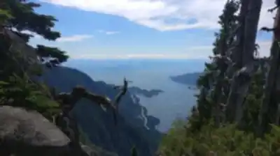
The summit sits at an elevation of approximately 1,370 meters (4,495 feet), providing hikers with commanding views across Howe Sound's island-dotted waters, the surrounding Coast Mountain peaks, and on exceptionally clear days, glimpses of distant Vancouver Island. This vantage point captures the dramatic contrast between the deep blue waters of the sound below and the rugged mountain terrain that defines this region.
The Trail Experience
The hike to Saint Marks Summit covers approximately 11 kilometers round trip, making it a substantial but manageable day hike for most outdoor enthusiasts. The trail presents a moderately challenging experience that rewards hikers with increasingly impressive views as elevation is gained.
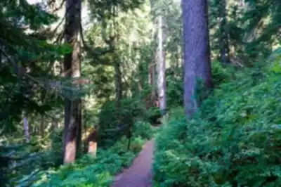
Your journey begins in dense coastal forest, where towering conifers create a cathedral-like canopy overhead. The initial sections wind through these lush woodlands, where the forest floor is carpeted with vibrant mosses and ferns typical of the Pacific Northwest's temperate rainforest ecosystem. The sound of your footsteps on the forest floor and the occasional call of local bird species provide a peaceful soundtrack to the early portions of the hike.
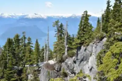
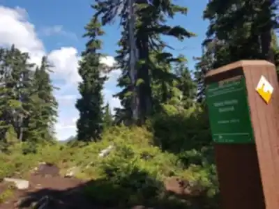
As you progress upward, the character of the trail begins to shift. The forest gradually opens up, and you'll encounter sections where the terrain becomes steeper and more rocky. These challenging portions require careful foot placement, but they signal that you're approaching the more dramatic alpine environment that awaits above.
The transition from dense forest to more open terrain marks one of the most exciting phases of the hike. Here, the trees begin to thin, and you'll catch your first tantalizing glimpses of the views that make this destination so popular. These preview moments build anticipation for the full panorama that awaits at the summit.
Summit Views and Highlights
Reaching Saint Marks Summit provides hikers with one of the finest viewpoints in the Vancouver area. The summit offers unobstructed 360-degree views that showcase the diverse landscape of southwestern British Columbia. To the west, Howe Sound stretches toward the Strait of Georgia, its deep blue waters punctuated by numerous islands that appear to float on the surface.
The surrounding Coast Mountain peaks create a dramatic backdrop, with their steep faces and alpine ridges extending in all directions. This vantage point allows you to appreciate the scale and ruggedness of the mountain terrain that lies just beyond Vancouver's urban boundaries.
The summit experience varies dramatically depending on the time of day you arrive. Sunrise visits reward early starters with soft golden light illuminating the mountain faces and creating mirror-like reflections on the sound's calm morning waters. Sunset timing offers equally spectacular lighting, as the western exposure provides front-row seats to the sun's descent toward the Pacific.
Trail Conditions and Terrain
The path to Saint Marks Summit presents varied terrain that keeps the hiking experience engaging throughout. The lower elevations feature well-established forest trails with good footing, though occasional roots and rocks require attention. As elevation increases, hikers encounter steeper grades and more technical sections where the trail becomes rocky and potentially slippery, especially in wet conditions.
These challenging sections are part of what makes the summit feel earned rather than given. The rocky terrain in the upper portions of the hike provides good traction when dry but can become treacherous when wet, making proper footwear essential for safety and comfort.
The final approach to the summit typically involves some scrambling over rocky outcrops, adding an element of adventure to the experience. These sections are manageable for most hikers with basic outdoor experience but do require attention and care.
Preparation and Equipment
Success and safety on Saint Marks Summit depend heavily on proper preparation. Sturdy hiking boots with good ankle support and aggressive tread patterns are essential, particularly for the rocky upper sections of the trail. The varied terrain and potential for loose rock make quality footwear a non-negotiable requirement.
Weather conditions in the Coast Mountains can change rapidly, and temperatures at the summit will be significantly cooler than at sea level. Layered clothing allows you to adjust to changing conditions throughout the day. A waterproof outer layer is recommended regardless of the forecast, as mountain weather can be unpredictable.
Adequate water and food are crucial for this length of hike. Plan to carry more water than you think you'll need, as the elevation gain and mountain air can increase dehydration. High-energy snacks help maintain stamina during the more challenging sections of the ascent.
A camera or smartphone is virtually mandatory for capturing the exceptional views from the summit. The panoramic vistas and dramatic lighting conditions provide countless photo opportunities that you'll want to preserve.
Access and Logistics
Saint Marks Summit is accessed via Cypress Mountain Resort, which sits just a short drive from downtown Vancouver. This convenient location makes the hike accessible as a day trip from the city, though the substantial elevation gain and distance mean you should plan for a full day adventure.
Ample parking is available at the resort's base area, providing secure vehicle storage while you're on the trail. The proximity to Vancouver makes this an ideal destination for both locals seeking a quick mountain escape and visitors wanting to experience British Columbia's mountain scenery without venturing far from the city.
Environmental Responsibility
The pristine nature of Saint Marks Summit and the surrounding Coast Mountains depends on responsible visitor behavior. Leave No Trace principles are essential for preserving this environment for future hikers. This means packing out all trash, staying on designated trails to prevent erosion and vegetation damage, and respecting wildlife by observing from a distance.
The fragile alpine environment near the summit is particularly sensitive to human impact. Avoiding shortcuts and staying on established paths helps protect the slow-growing vegetation that thrives in these harsh mountain conditions.
Recommended gear for this trail


Ready to go?
Everything you need to know before you goStarting Point
The saint marks summit is located in the Rocky Mountains of British Columbia, Canada. The nearest town is Invermere, which is about a one-hour drive from the summit.
When?
How much?
- Hiking shoes Essential
- → Salomon Elixir Tour Mid WP · 203.38 $
- Layered clothing Essential
- Rain jacket Essential
- Trekking poles
- → Black Diamond Trail Ergo Cork · 69.99 $
- Headlamp
- → Petzl Actik Core 625 · 103.95 $
FAQ - Frequently asked questions
Everything you need to knowThe Essential Hiking Checklist
Everything you need for your next hike. Bilingual, printable, 1 page.
Download the free checklistSimilar hikes nearby
Discover other trails you might enjoy

Bridle Path
Vancouver Coast Mountains
Flora Lake
Vancouver Coast Mountains

Alouette Mountain
Vancouver Coast Mountains

Williamson Lake
Vancouver Coast Mountains
Brandywine Mountain
Vancouver Coast Mountains

Coliseum Mountain
Vancouver Coast Mountains
Hiking near Vancouver
235 trails to explore ~17 km away
We work hard to provide the most up-to-date and error-free data possible. If something seems incorrect, let us know! Your contribution helps the whole community.
Hikers' opinions
Be the first to review!
No hiker has shared their experience yet. Share your impressions and help other hikers!