

Ready to explore Savary Island? Here's everything you need to know before you go!
Discover the trail

Trail description
Description
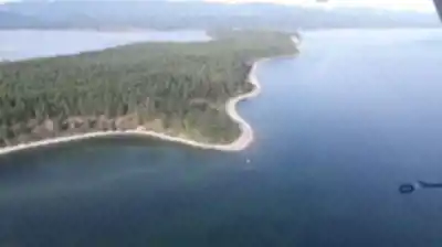
Savary Island sits in the Strait of Georgia, accessible by water taxi from the small coastal town of Lund, BC. This 7-kilometer-long island combines sandy beaches with forested interior trails, creating an unusual hiking destination that feels more like the Gulf Islands than the rugged Vancouver Coast Mountains region it's technically part of. The island's relatively flat terrain and network of informal paths make it particularly appealing for families and hikers looking for a gentler outdoor experience.
The Trail Network
Savary Island's trail system consists of interconnected paths that wind through the island's forested interior, connecting beaches, residential areas, and viewpoints. These aren't maintained hiking trails in the traditional sense, but rather a collection of informal paths, old logging roads, and beach access routes that locals and visitors have used for decades. The trails meander through stands of Douglas fir and cedar, providing cool shade during summer months and creating a peaceful walking environment.
Most paths are well-defined and easy to follow, though you won't find trail markers or detailed signage. The island's compact size means it's difficult to get seriously lost, and most routes eventually lead either to a beach or back to the main residential area near the government wharf. The terrain is generally flat with only minor elevation changes, making these trails accessible to hikers of all experience levels.
The walking experience here is unique in the Vancouver Coast Mountains region. Instead of steep switchbacks and challenging climbs, you'll find gentle undulations through mixed forest. The soft forest floor, carpeted with fallen needles and moss, provides comfortable footing. Sunlight filters through the canopy, creating dappled patterns on the trail surface and highlighting the understory vegetation of salal, Oregon grape, and ferns.
Wildlife sightings are common throughout the forested areas. Deer move freely across the island and often graze near the trails, particularly in early morning and evening hours. The diverse bird population includes both forest species and shorebirds, with eagles frequently spotted soaring overhead or perched in the tall conifers. The island's isolation has created a relatively fearless wildlife population, making encounters more likely and memorable than in heavily trafficked mainland areas.
Beach Access and Coastal Walking
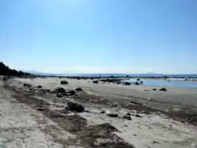
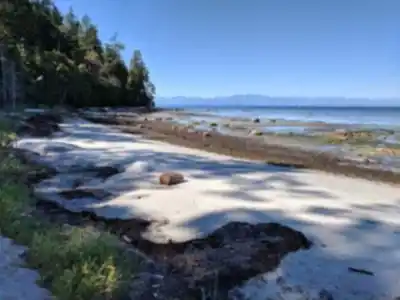
The island's main draw is its exceptional sandy beaches, particularly the long stretch of sand on the north side that faces the mainland. These beaches provide excellent walking opportunities at low tide, when the sand extends far out into the strait. The contrast between forested trails and open beach environments gives hikers variety within a relatively small area.
Beach walking here differs significantly from the rocky coastlines typical of most Vancouver Coast Mountains destinations. The sand is fine and firm, making for easy walking, and the gradual slope into the water creates extensive tidal flats during low tide. This unique coastal environment supports different wildlife than you'd find on typical BC hiking trails, including various shorebird species and marine life in the tidal pools.
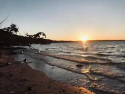
The beaches also serve as natural rest stops and picnic areas. After exploring the inland trails, many visitors spend time on the sand, swimming in the surprisingly warm waters during summer months. The protected location of the island creates calmer conditions than the open ocean, making beach activities more comfortable. The expansive views across the strait to the mainland mountains provide a stunning backdrop that changes throughout the day as light conditions shift.
Navigation and Route Planning
While the island's trail network might seem informal, there's a logical flow to exploring it effectively. Most visitors start from the government wharf area and work their way through the interior trails before ending up on the beaches. The interconnected nature of the paths means you can create loops of varying lengths, from short 30-minute walks to longer explorations that can easily fill several hours.
The lack of formal trail markers actually adds to the adventure. You'll rely on natural navigation skills and the occasional glimpse of the water through the trees to maintain your bearings. Local residents have worn the main paths well enough that route-finding rarely becomes problematic, but carrying a basic map or GPS device can provide peace of mind for less confident navigators.
The island's small size works in your favor – even if you take a wrong turn, you'll eventually reach either a beach or a recognizable landmark. This forgiving environment makes Savary Island an excellent place for novice hikers to build confidence in their navigation skills without serious consequences for minor mistakes.
Getting There and Island Logistics
Reaching Savary Island requires planning around the water taxi schedule from Lund. The boat ride itself takes about 20 minutes and offers views of the surrounding islands and mainland mountains. This water approach adds an element of adventure to the hiking experience and helps create the sense of arriving somewhere truly separate from the mainland.
Once on the island, transportation is primarily on foot or by bicycle. There are no cars for visitors, which contributes to the peaceful atmosphere but also means you'll be carrying everything you need for your visit. The main landing area near the government wharf provides the starting point for most trail exploration.
The island has a small but active residential community, particularly during summer months. These friendly locals often provide informal guidance about trail conditions and interesting spots to explore. Their presence adds a social element to the hiking experience that's unusual in more remote wilderness areas.
Seasonal Considerations and Planning
Summer offers the most comfortable hiking conditions, with warm temperatures, minimal rainfall, and the best opportunities for combining trail exploration with beach activities. The island's beaches are particularly appealing during hot weather, providing cooling opportunities that aren't available on most mountain hikes.
Spring and fall can also provide excellent hiking conditions, with fewer crowds and often clearer views across the strait. However, weather can be more unpredictable, and the water taxi service may have reduced schedules during off-season periods. Winter visits are possible but require careful attention to weather conditions and boat schedules.
The island's exposed location means weather can change quickly, and conditions on the water may differ from those on land. Even during summer, bringing layers and rain protection is advisable. The lack of services on the island means carrying adequate water and food for your entire visit.
What Makes Savary Island Unique
Savary Island offers a hiking experience that's distinctly different from typical Vancouver Coast Mountains destinations. Instead of steep climbs to alpine viewpoints, you get gentle forest walks combined with extensive beach exploration. The island environment creates a sense of isolation and adventure while remaining accessible to hikers who might find traditional mountain trails too challenging.
The combination of forest and beach environments in such a compact area provides remarkable variety. You can move from shaded forest paths to open sandy beaches within minutes, experiencing different ecosystems and wildlife habitats during a single visit. This diversity, combined with the island's peaceful atmosphere and friendly community, creates a hiking destination that feels both adventurous and relaxing.
The water taxi access adds an element of expedition-style travel to what is essentially an easy hiking experience, making it appealing for families or groups with mixed hiking abilities who still want to feel like they're embarking on a real adventure.
Recommended gear for this trail


Ready to go?
Everything you need to know before you goStarting Point
To access the hiking trails, you can start by heading to Lund, British Columbia. From there, take a water taxi or private boat to reach the island. The main trailhead is accessible from the dock area where you arrive. There are no specific addresses for trailheads on the island, but once you disembark, you'll find signs and paths leading to various trails.
When?
How much?
- Hiking shoes Essential
- → Salomon Elixir Tour Mid WP · 203.38 $
- Layered clothing Essential
- Rain jacket Essential
- Trekking poles
- → Black Diamond Trail Ergo Cork · 69.99 $
- Headlamp
- → Petzl Actik Core 625 · 103.95 $
FAQ - Frequently asked questions
Everything you need to knowThe Essential Hiking Checklist
Everything you need for your next hike. Bilingual, printable, 1 page.
Download the free checklistSimilar hikes nearby
Discover other trails you might enjoy

Bridle Path
Vancouver Coast Mountains
Flora Lake
Vancouver Coast Mountains

Alouette Mountain
Vancouver Coast Mountains

Williamson Lake
Vancouver Coast Mountains
Brandywine Mountain
Vancouver Coast Mountains

Coliseum Mountain
Vancouver Coast Mountains
Hiking near Nanaimo
212 trails to explore ~107 km away
We work hard to provide the most up-to-date and error-free data possible. If something seems incorrect, let us know! Your contribution helps the whole community.
Hikers' opinions