

Ready to explore Sunshine Coast Trail? Here's everything you need to know before you go!
Discover the trail


Trail description
Description
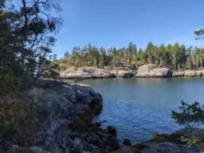
The Sunshine Coast Trail stands as Canada's longest hut-to-hut hiking experience, stretching 180 kilometers along British Columbia's Sunshine Coast from Sarah Point in Desolation Sound to Saltery Bay. This world-class hiking route lies just a half-day's journey from downtown Vancouver, yet feels remarkably remote and wild.
What makes this trail extraordinary is its incredible diversity of landscapes. You'll traverse coastal shorelines where waves crash against rocky bluffs, meander through ancient old-growth rainforests with towering cedars and firs, climb to panoramic mountaintops offering sweeping vistas of the Salish Sea, and walk alongside pristine lakes and creeks. The trail weaves through everything from dense forest canopy to open meadows, providing a comprehensive showcase of coastal British Columbia's natural beauty.
The trail's unique hut-to-hut system sets it apart from other long-distance routes. Fourteen strategically placed huts dot the trail at stunning locations, with one more planned for next year. Each hut provides shelter, outhouses, and picnic tables or benches, making multi-day adventures more comfortable and accessible. Three of the higher elevation huts are winterized, keeping portions of the trail accessible year-round. Best of all, this entire hut system is completely free to use.
Trail History and Development
The Sunshine Coast Trail began as the vision of Eagle Walz and a small group who founded the Powell River Parks and Wilderness Society (PAWS) in 1992. Their original goal was to build hiking trails linking the remaining stands of old-growth forests in the region before they disappeared to logging. Twenty-five years later, their efforts have not only preserved much of the Sunshine Coast's old growth but created a trail over twice as long as the famous West Coast Trail on Vancouver Island.
Eagle Walz continues to play a major role in expanding and upgrading the trail, supported by countless volunteers who maintain this remarkable hiking experience. The trail has evolved from a local conservation project into an internationally recognized destination that attracts hikers from around the world.
Getting There
Reaching the Sunshine Coast requires ferry travel, which adds to the sense of adventure but requires planning. From Vancouver, you must take the ferry from Horseshoe Bay to Langdale (40 minutes), then drive to Earl's Cove for the 50-minute crossing to Saltery Bay. Allow six hours total travel time from Vancouver to Powell River, the only major town along the trail route. Alternatively, you can reach Powell River by ferry from Comox on Vancouver Island.
The trail officially begins at Sarah Point, but you don't need to start there. Multiple access points allow hikers to explore smaller sections or create custom itineraries. To reach Sarah Point, take a water taxi operated by TerraCentric Adventures from Lund. If you're planning to hike to Manzanita Hut, leave Lund no later than 9 AM as it makes for a long hiking day.
Trail Sections and Highlights
The trail passes through Powell River, making it easy to resupply or take a break at the Shinglemill Pub and Bistro, which sits right where the trail exits town. You can also arrange parking here for $5 per day while hiking other sections.
Popular destinations include Manzanita Hut, reached after a challenging 16-kilometer trek from Sarah Point through varied terrain. Tin Hat Mountain Hut ranks among the most scenic stops, though reaching it requires one of the trail's more difficult sections—climbing about 1,000 meters over 7 kilometers.
Mount Troubridge represents the trail's highest point at 1,305 meters, located around kilometer 158. From this summit, you'll enjoy spectacular views over Jervis Inlet and the largest section of old growth forest accessed by the trail. Fairview Hut provides another excellent base, with good cell phone coverage and relatively easy access.
Fiddlehead Landing offers a gentler experience, exploring forest sections along Powell Lake shores. This area requires boat access from Powell River but rewards hikers with beautiful lakeside scenery. The final section from Fairview Bay to Saltery Bay returns to the Salish Sea shores, completing the coast-to-coast journey where you might spot ferries connecting the Lower and Upper Sunshine Coast.
Practical Considerations
Water availability varies significantly between huts, so careful planning is essential. For example, hikers heading to Manzanita Hut from Sarah Point must fill water containers 4 kilometers before reaching the hut, as no water source exists at the hut itself. Always check current water source information before departing.
Cell phone coverage is spotty but exists at several key locations. Expect service at Jocelyn Pond, Fairview Hut, Manzanita Hut, Rieveley Pond Hut, and most of the trail section leading to Saltery Bay. High elevation points generally offer better signal strength when coverage is available.
Wildlife encounters are common, particularly with black bears. Hikers frequently encounter fresh bear scat within minutes of starting the trail, so proper food storage and bear safety protocols are essential. Carry bear spray and know how to use it.
Planning Your Visit
The complete trail requires 10 to 12 days for most backpackers, though the experience becomes more rewarding with three or more days on the trail as you settle into the rhythm of hut-to-hut hiking. The driest months for hiking are May, July, August, and September, though the winterized huts make year-round access possible for experienced winter hikers.
Essential resources include the Recreation Map from the Powell Lake Visitor's Centre and "The Sunshine Coast Trail - Hut To Hut Hiking" by R.E. Walz. Stock up on food in Powell River, which offers the largest selection along the route.
For secure parking while on the trail, SunLund By the Sea campground near Lund provides parking services, with owners Ann and Ron Snow noting that the trail now attracts international visitors who specifically come to hike portions of this remarkable route.
Recommended gear for this trail


Ready to go?
Everything you need to know before you goStarting Point
The sunshine coast trail is located in the town of Gibsons on the Sunshine Coast of British Columbia. The trailhead is located at the end of Mermaid Lane in Gibsons.
When?
How much?
- Hiking shoes Essential
- → Salomon Elixir Tour Mid WP · 203.38 $
- Layered clothing Essential
- Rain jacket Essential
- Trekking poles
- → Black Diamond Trail Ergo Cork · 69.99 $
- Headlamp
- → Petzl Actik Core 625 · 103.95 $
FAQ - Frequently asked questions
Everything you need to knowThe Essential Hiking Checklist
Everything you need for your next hike. Bilingual, printable, 1 page.
Download the free checklistSimilar hikes nearby
Discover other trails you might enjoy

Bridle Path
Vancouver Coast Mountains
Flora Lake
Vancouver Coast Mountains

Alouette Mountain
Vancouver Coast Mountains

Williamson Lake
Vancouver Coast Mountains
Brandywine Mountain
Vancouver Coast Mountains

Coliseum Mountain
Vancouver Coast Mountains
Hiking near Nanaimo
212 trails to explore ~105 km away
We work hard to provide the most up-to-date and error-free data possible. If something seems incorrect, let us know! Your contribution helps the whole community.
Hikers' opinions