

Ready to explore Texada Island? Here's everything you need to know before you go!
Discover the trail

Trail description
Description
Texada Island stands as the largest of the Gulf Islands, offering hikers a remarkable blend of rugged wilderness and coastal beauty within the Vancouver Coast Mountains region. This 50-kilometer-long island delivers diverse terrain that ranges from dense old-growth forests to dramatic rocky shorelines, making it a compelling destination for outdoor enthusiasts seeking both challenge and solitude.
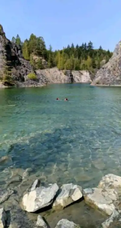
The island's unique character stems from its fascinating geological history and former mining operations, which have left behind intriguing rock formations and mineral deposits scattered throughout the landscape. As you explore the trail network, you'll traverse terrain that tells the story of both natural forces and human industry, creating a hiking experience unlike anywhere else in the region.
Trail Network and Hiking Options
Texada Island's well-maintained trail system accommodates hikers of all experience levels, with paths that wind through varied ecosystems and lead to spectacular viewpoints. The network connects different parts of the island, allowing you to customize your adventure based on time, fitness level, and interests.
The crown jewel of the island's hiking opportunities is the Mount Pocahontas Trail, a moderate 4.8-kilometer route that gains 400 meters of elevation over approximately 2.5 hours. This trail takes you deep into dense coastal forests where towering Douglas firs and western red cedars create a cathedral-like canopy overhead. The path initially follows gentle switchbacks through the forest understory, where you'll encounter moss-covered boulders and seasonal wildflowers.
As you gain elevation on Mount Pocahontas, the forest gradually opens up, revealing glimpses of the surrounding landscape through the trees. The final push to the summit rewards your effort with panoramic views that stretch across the Strait of Georgia to the mainland mountains and neighboring Gulf Islands. On clear days, the vista encompasses the snow-capped peaks of the Coast Range, creating a dramatic backdrop that makes this moderate climb feel like a major mountain adventure.
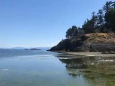
For those preferring gentler terrain, Shelter Point Regional Park provides an excellent alternative with its network of easy coastal trails. These paths meander along the shoreline, offering stunning ocean vistas and opportunities to observe marine life from elevated viewpoints. The park's trails are perfect for families or anyone wanting to enjoy the island's natural beauty without significant elevation gain. The well-positioned benches and picnic areas make this an ideal spot to combine hiking with relaxation by the water.
Natural Environment and Wildlife
The island's diverse ecosystems support an impressive array of wildlife that adds excitement to every hike. Black-tailed deer are commonly spotted throughout the forested areas, often appearing along trail edges during early morning or late afternoon hours. Keep your eyes on the sky for bald eagles, which frequently soar overhead or perch in the tall conifers near the coastline.
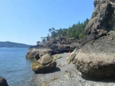
Along the rocky shores and beaches, harbor seals and sea lions are regular visitors, particularly around Shelter Point where the calm waters provide ideal resting spots. The intertidal zones reveal fascinating marine life during low tide, including colorful sea stars, anemones, and various crab species.
The island's plant communities reflect its unique position between coastal and interior climates. Dense forests of Douglas fir, western hemlock, and western red cedar dominate the interior, while the coastal areas feature hardy shrubs and wildflowers adapted to salt spray and wind exposure. Spring brings vibrant displays of trilliums, wild roses, and other native flowers that carpet the forest floor.
Texada's geological diversity creates microhabitats that support specialized plant communities. The exposed rock faces and mineral-rich soils left from mining activities have allowed unique plant associations to develop, making botanical exploration an additional reward for observant hikers.
Access and Transportation
Reaching Texada Island requires some planning, but the journey becomes part of the adventure. BC Ferries operates regular service from Powell River on the mainland, with the crossing taking approximately 35 minutes. The ferry accommodates both vehicles and foot passengers, though many visitors find that bringing a car provides the most flexibility for accessing different trailheads across the island.
For those seeking a more direct route, small aircraft service is available from Vancouver, landing at the island's airstrip. This option significantly reduces travel time and provides spectacular aerial views of the Gulf Islands during the flight.
Once on the island, the main roads provide access to most trailheads, though some require short drives on gravel roads. The island's compact size makes it easy to explore multiple areas during a single visit, whether you're planning a day trip or extended stay.
Community and Local Character
Texada Island's small but vibrant community adds a welcoming dimension to any hiking visit. The island's residents take pride in maintaining the trail system and sharing their knowledge of the best hiking spots with visitors. Local businesses provide essential services and often serve as informal information centers where you can get current trail conditions and recommendations.
The annual Sandcastle Weekend exemplifies the island's creative spirit and community connection, offering visitors a chance to experience local culture alongside their outdoor adventures. These community events provide insight into island life and create opportunities to connect with residents who are passionate about their unique home.
The island's mining heritage remains visible throughout the landscape, with old quarries and processing sites now serving as interesting historical stops along hiking routes. These remnants tell the story of Texada's industrial past while demonstrating nature's ability to reclaim and transform human-altered landscapes into new forms of beauty.
Recommended gear for this trail


Ready to go?
Everything you need to know before you goStarting Point
To access the hiking trails, you can start at several trailheads on the island. One common starting point is the parking area near Shelter Point Regional Park, located at 4421 Gillies Bay Road. Another option is to begin your hike from the trailhead at Bob's Lake, which can be accessed via Central Road. Both locations provide convenient access to various trails on the island.
When?
How much?
- Hiking shoes Essential
- → Salomon Elixir Tour Mid WP · 203.38 $
- Layered clothing Essential
- Rain jacket Essential
- Trekking poles
- → Black Diamond Trail Ergo Cork · 69.99 $
- Headlamp
- → Petzl Actik Core 625 · 103.95 $
FAQ - Frequently asked questions
Everything you need to knowThe Essential Hiking Checklist
Everything you need for your next hike. Bilingual, printable, 1 page.
Download the free checklistSimilar hikes nearby
Discover other trails you might enjoy

Bridle Path
Vancouver Coast Mountains
Flora Lake
Vancouver Coast Mountains

Alouette Mountain
Vancouver Coast Mountains

Williamson Lake
Vancouver Coast Mountains
Brandywine Mountain
Vancouver Coast Mountains

Coliseum Mountain
Vancouver Coast Mountains
Hiking near Nanaimo
212 trails to explore ~65 km away
We work hard to provide the most up-to-date and error-free data possible. If something seems incorrect, let us know! Your contribution helps the whole community.
Hikers' opinions
Be the first to review!
No hiker has shared their experience yet. Share your impressions and help other hikers!