

Ready to explore Watersprite Lake? Here's everything you need to know before you go!
Discover the trail

Trail description
Description
Watersprite Lake sits tucked away in the Vancouver Coast Mountains, offering one of the most rewarding day hikes accessible from the Sea-to-Sky corridor. This alpine gem delivers the kind of pristine mountain lake experience that makes British Columbia's backcountry legendary, combining a solid workout with scenery that shifts dramatically as you climb toward the subalpine zone.
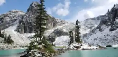
The lake itself justifies every step of the approach—crystal-clear turquoise waters reflect the surrounding peaks in a classic cirque setting that feels worlds away from the coastal rainforest you'll hike through to reach it. What sets Watersprite apart from other alpine lakes in the region is its accessibility as a day trip from Vancouver while still maintaining that remote wilderness character that serious hikers seek.
Trail Details and What to Expect
The 8.5-kilometer journey to Watersprite Lake falls into the moderate difficulty category, with 660 meters of elevation gain distributed fairly evenly throughout the route rather than concentrated in one brutal section. Plan on roughly 3.5 hours to reach the lake, though many hikers find themselves taking longer as the scenery demands frequent photo stops.
The trail begins in the dense coastal forest typical of this region, where you'll cross several babbling creeks and navigate through sections of old-growth timber. The path is well-marked throughout, but expect to encounter some technical terrain as you progress. Rocky sections become more frequent in the upper portions of the hike, and you'll find yourself picking your way across uneven ground and navigating some steep pitches that require careful foot placement.
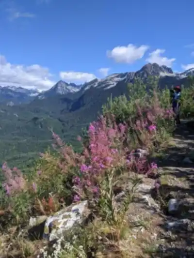
As you gain elevation, the forest composition changes noticeably. The lower sections feature the lush undergrowth and towering conifers characteristic of the coastal temperate rainforest, while higher up, the trees become smaller and the understory opens up. This transition zone often provides excellent opportunities for wildlife viewing, and during the right season, you'll encounter vibrant displays of wildflowers that add splashes of color to the green palette of the forest.
The final approach to the lake involves some of the most challenging terrain of the hike, but it's also where the payoff begins. Panoramic views start opening up of the surrounding mountains and valleys, giving you glimpses of the dramatic landscape that defines this part of the Coast Mountains. These viewpoints provide natural rest stops where you can catch your breath and appreciate just how much elevation you've gained.
The Lake Experience
Watersprite Lake occupies a classic alpine cirque, surrounded by towering peaks that create a natural amphitheater around the water. The lake's distinctive turquoise color comes from glacial flour—fine rock particles suspended in the water that scatter light in a way that produces those incredible blue-green hues that make mountain lakes so photogenic.
The shoreline offers several excellent spots for taking a break, enjoying lunch, or simply soaking in the mountain atmosphere. The rocky areas around the lake provide natural seating with unobstructed views across the water to the surrounding peaks. This is prime territory for photography, whether you're capturing the dramatic mountain reflections in the still water or the interplay of light and shadow on the surrounding rock faces.
The tranquility of the lake environment provides a stark contrast to the effort required to reach it. After hours of steady climbing through forest, the sudden opening into this alpine basin feels like stepping into a different world entirely. It's the kind of place that invites you to linger, and many hikers find themselves spending more time at the lake than they initially planned.
Planning and Preparation
This hike demands proper preparation, starting with appropriate footwear. Sturdy hiking boots with good ankle support are essential given the rocky terrain and uneven surfaces you'll encounter, particularly in the upper sections of the trail. The combination of creek crossings, rocky scrambles, and potentially muddy forest sections means your feet will face varied challenges throughout the day.
Water and nutrition planning becomes critical on a hike with significant elevation gain. Carry more water than you think you'll need, and pack substantial snacks or a proper trail lunch. The physical demands of this hike mean your body will be burning through calories and fluids steadily throughout the day.
Weather conditions can change rapidly in the mountains, and the elevation gain means you'll experience different conditions at the lake than you encountered at the trailhead. Layer your clothing system to handle everything from the humid forest environment at lower elevations to potentially cool and windy conditions at the alpine lake. Even on warm days, temperatures can drop significantly once you reach the lake, especially if clouds move in.
The remote nature of this location means cell phone service is limited or nonexistent throughout most of the hike. Always inform someone of your hiking plans, including your expected return time, before heading out. This basic safety protocol becomes even more important on longer, more challenging hikes like Watersprite Lake.
Camping and Extended Stays
For those wanting to extend their Watersprite Lake experience beyond a day trip, camping opportunities exist near the lake. The alpine setting provides a completely different experience after the day hikers have departed, with opportunities for sunset and sunrise photography that showcase the lake and surrounding peaks in different light.
Camping in this pristine environment comes with the responsibility to practice Leave No Trace principles rigorously. The fragile alpine ecosystem around the lake requires careful treatment to preserve its condition for future visitors. This means proper waste disposal, camping only in designated or previously impacted areas, and minimizing your impact on the vegetation and shoreline around the lake.
Recommended gear for this trail


Ready to go?
Everything you need to know before you goStarting Point
The start of the trails at the watersprite lake can be accessed by travelling east on Highway 3 from Princeton, British Columbia. The trailhead is located approximately 9 kilometres from the town of Princeton.
When?
How much?
- Hiking shoes Essential
- → Salomon Elixir Tour Mid WP · 203.38 $
- Layered clothing Essential
- Rain jacket Essential
- Trekking poles
- → Black Diamond Trail Ergo Cork · 69.99 $
- Headlamp
- → Petzl Actik Core 625 · 103.95 $
FAQ - Frequently asked questions
Everything you need to knowThe Essential Hiking Checklist
Everything you need for your next hike. Bilingual, printable, 1 page.
Download the free checklistSimilar hikes nearby
Discover other trails you might enjoy

Bridle Path
Vancouver Coast Mountains
Flora Lake
Vancouver Coast Mountains

Alouette Mountain
Vancouver Coast Mountains

Williamson Lake
Vancouver Coast Mountains
Brandywine Mountain
Vancouver Coast Mountains

Coliseum Mountain
Vancouver Coast Mountains
Hiking near Squamish
211 trails to explore ~19 km away
We work hard to provide the most up-to-date and error-free data possible. If something seems incorrect, let us know! Your contribution helps the whole community.
Hikers' opinions