

Ready to explore Wedgemount Lake? Here's everything you need to know before you go!
Discover the trail

Trail description
Description
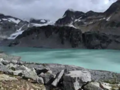
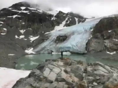
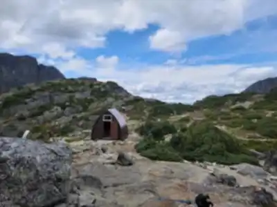
Wedgemount Lake delivers one of the most spectacular alpine experiences in the Vancouver Coast Mountains, but it demands serious effort to reach. This stunning glacial lake sits at 1,920 meters elevation, where turquoise waters reflect towering granite walls and the impressive Wedgemount Glacier. The 14-kilometer round trip with 1,160 meters of elevation gain ranks as a hard hike that typically takes 6.5 hours to complete.
Located in British Columbia's Coast Mountains, this trail attracts hikers seeking a genuine wilderness experience within day-trip distance of Vancouver. The lake's remote alpine setting and challenging approach mean you'll encounter fewer crowds than easier destinations, making it perfect for those wanting to escape the busy lower elevation trails.
The Trail Experience
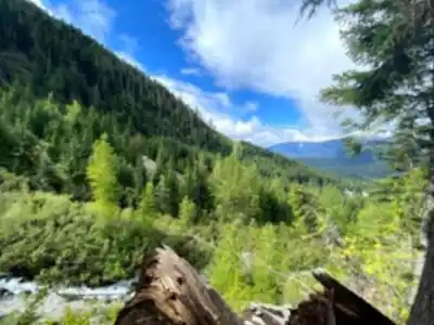
Don't expect any warm-up on this hike—the steep climbing starts immediately from the trailhead and rarely lets up. The well-maintained trail climbs relentlessly through dense coastal forest for the first several kilometers, where massive cedars and Douglas firs provide shade as you gain elevation quickly.
The forest gradually transitions to subalpine terrain as you climb higher, opening into meadows that explode with wildflowers during peak season. Indian paintbrush, lupine, and mountain heather create colorful displays from late June through August. The trail becomes increasingly rocky and technical in the upper sections, with loose scree, exposed roots, and granite slabs requiring careful footing.
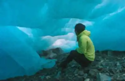
The final approach involves scrambling over large boulders and granite outcrops. Your first view of the lake often comes suddenly—that brilliant turquoise water appears almost shocking against the stark granite cirque. The Wedgemount Glacier dominates the far shore, its crevassed ice creating a dramatic backdrop that changes throughout the day as light shifts across the peaks.
What Makes This Destination Special
Wedgemount Lake offers pure alpine beauty without compromise. No trees soften the harsh landscape of granite walls, glacial ice, and impossibly blue water. The cirque creates a natural amphitheater with steep walls rising dramatically on three sides, while snow often persists on north-facing slopes well into summer.
On calm days, the lake's surface becomes a perfect mirror reflecting the surrounding peaks and glacier. The setting feels genuinely remote despite being accessible as a day hike, providing that wilderness experience that's increasingly rare near major population centers. The challenging approach filters out casual visitors, so you'll mostly encounter serious hikers and mountaineers using this area for training or accessing technical climbing routes.
Best Times to Visit
Plan your trip between late June and early October when the trail is generally snow-free. Even during these months, expect snow patches in shaded areas and around the lake itself. Early season visits in June and July offer the best wildflower displays, while September typically provides the most stable weather with fewer crowds.
Start early—aim to be hiking by 7 AM to avoid afternoon thunderstorms that are common in summer. Mountain weather changes rapidly here, and conditions at the lake can differ dramatically from the valley. What starts as a perfect bluebird day can turn stormy quickly at elevation.
Winter access is technically possible but becomes a serious mountaineering undertaking requiring avalanche knowledge, winter camping gear, and advanced route-finding skills.
Essential Gear and Preparation
Sturdy hiking boots with good ankle support are absolutely critical—the rocky, steep terrain will punish inadequate footwear. Trekking poles provide valuable stability on the ascent and reduce knee stress during the long descent back down.
Carry significantly more water than you think you need. The sustained climb and high elevation increase your fluid requirements substantially. Plan on at least 3 liters per person, plus high-energy snacks to maintain stamina throughout the demanding ascent.
Layer your clothing carefully. Temperatures at the lake can be 15-20 degrees cooler than at the trailhead, and weather can deteriorate without warning. Pack a warm insulating layer and waterproof shell even on seemingly perfect days. The exposed alpine environment offers no shelter from wind, rain, or sudden temperature drops.
Safety and Environmental Considerations
This trail's remote location and steep terrain mean rescue would be difficult and time-consuming. Self-sufficiency and good judgment are essential for a safe trip. Check current trail conditions before departing, as late-season snow, washouts, or other hazards can make the route dangerous or impassable.
The pristine alpine environment around Wedgemount Lake is extremely fragile and shows damage easily while recovering slowly. Practice strict Leave No Trace principles by packing out all waste, staying on established trails, and resisting the urge to build rock cairns or otherwise alter the landscape.
Be prepared for the physical demands of this hike. The sustained steep climbing tests your endurance, and the technical terrain in the upper sections requires focus and sure footing. Many hikers underestimate the difficulty and find themselves struggling on the descent when fatigue sets in.
Recommended gear for this trail


Ready to go?
Everything you need to know before you goStarting Point
To access the trailhead for the hiking trails, head towards the parking lot located at the end of wedgemount lake Road. From Highway 99, take the turnoff onto Mount Currie Road and follow it until you reach wedgemount lake Road. Continue on this road until you arrive at the designated parking area. There is only one main trailhead for this hike.
When?
How much?
- Hiking shoes Essential
- → Salomon Elixir Tour Mid WP · 203.38 $
- Layered clothing Essential
- Rain jacket Essential
- Trekking poles
- → Black Diamond Trail Ergo Cork · 69.99 $
- Headlamp
- → Petzl Actik Core 625 · 103.95 $
FAQ - Frequently asked questions
Everything you need to knowThe Essential Hiking Checklist
Everything you need for your next hike. Bilingual, printable, 1 page.
Download the free checklistSimilar hikes nearby
Discover other trails you might enjoy

Bridle Path
Vancouver Coast Mountains
Flora Lake
Vancouver Coast Mountains

Alouette Mountain
Vancouver Coast Mountains

Williamson Lake
Vancouver Coast Mountains
Brandywine Mountain
Vancouver Coast Mountains

Coliseum Mountain
Vancouver Coast Mountains
Hiking near Whistler
160 trails to explore ~11 km away
We work hard to provide the most up-to-date and error-free data possible. If something seems incorrect, let us know! Your contribution helps the whole community.
Hikers' opinions