

Ready to explore Cape Scott Provincial Park? Here's everything you need to know before you go!
Discover the trail
Trail description
Description
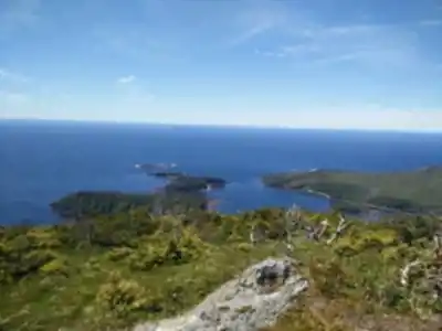
Cape Scott Provincial Park sits at the northwestern tip of Vancouver Island, covering 22,000 hectares where old-growth coastal rainforest collides with the full force of the open Pacific. This is genuinely remote wilderness — no visitor center, no concession stand, no cell service. What you get instead is raw, wind-scoured coastline, towering Sitka spruce and western hemlock, and beaches that feel like they belong to no one. If you're looking for a polished park experience, this isn't it. If you want to feel like you've actually earned your view, Cape Scott delivers.
The Trails
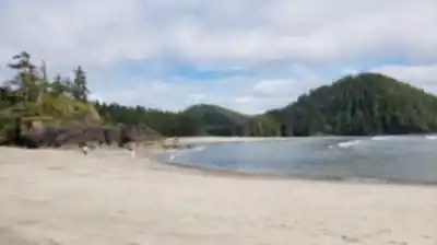
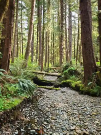
The park's signature route is the Cape Scott Trail, a roughly 23-kilometer trek from the trailhead out to the historic lighthouse at Cape Scott. This is a full-day commitment at minimum, and most people spread it over multiple days. The trail starts in dense rainforest where cedar and fir trees form a canopy thick enough to block out the sky. Wooden boardwalks cover the worst of the muddy sections, but don't expect to keep your boots clean — mud is part of the deal, especially from fall through spring. As you push toward the coast, the forest gradually opens up, and eventually you're walking across sandy beaches and rocky headlands with Pacific swells breaking against sea stacks below. The lighthouse at the end is no longer operational, but it's a satisfying landmark that marks the northernmost accessible point of Vancouver Island.
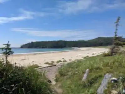
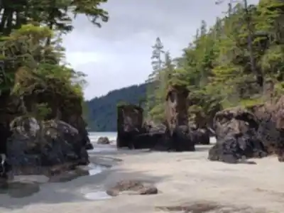
For something more manageable, the San Josef Bay Trail is a 2.5-kilometer walk through old-growth forest that ends at one of the most dramatic beaches in the park. Sea stacks rise straight out of the sand, the terrain is relatively flat, and the whole thing is accessible to most fitness levels. It's a great option if you want a taste of what Cape Scott is about without committing to a multi-day expedition.
Terrain and Trail Conditions
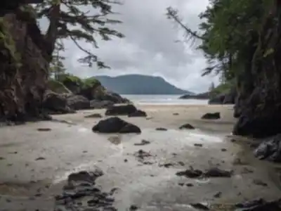
Cape Scott is not a groomed trail system. The coastal rainforest environment means you'll deal with roots, mud, slippery boardwalks, and creek crossings on a regular basis. Water levels in the creeks can rise fast after heavy rain, so check conditions before heading out and know your bailout options. Waterproof boots aren't optional here — they're mandatory, regardless of the season.
The transition from forest to coast adds its own challenges. You'll scramble over massive driftwood logs piled above the high-tide line, navigate beach cobble, and slog through soft sand that tires your legs faster than you'd expect. Once you hit the exposed headlands, wind becomes a real factor. Weather shifts quickly at the cape, and a calm morning can turn into a cold, wet slog by early afternoon. Layering is essential, and a waterproof shell should always be within reach.
Wildlife
Black bears are common throughout the park, particularly during berry season and salmon runs. Wolves also live here, though you're less likely to cross paths with them. On the coast, keep an eye on the water — seals and sea lions haul out on rocks, and whales are occasionally spotted offshore. The intertidal zones are worth exploring at low tide, with sea anemones, starfish, and shellfish visible in the rock pools.
Birdlife is strong in both the forest and coastal sections. Varied thrushes and winter wrens are common in the trees, while oystercatchers and cormorants work the shoreline. Store your food properly and use the bear caches provided at designated camping areas — it's mandatory, not optional.
Backcountry Camping
Several backcountry campsites are scattered through the park, with the most sought-after spots near the coast. These are primitive sites — pit toilets and bear caches are provided, but there are no fire rings, picnic tables, or treated water. You need to be fully self-sufficient. Freshwater sources exist throughout the park, but treat everything before drinking. Coastal camping means falling asleep to the sound of waves, which sounds idyllic until a Pacific storm rolls in at 2 a.m. and tests your tent's rain fly. Bring gear that can handle it.
Getting Ready for Cape Scott
The park is accessible year-round, but summer gives you the most stable weather and the longest daylight hours. Winter brings more frequent storms, shorter days, and creek crossings that can become genuinely dangerous. Whenever you go, tell someone your plans and your expected return time — there's no cell service in the park, and emergency response from this corner of Vancouver Island takes time.
- Waterproof boots are essential in every season
- Pack a waterproof shell and warm layers regardless of the forecast
- Carry a GPS device or detailed topographic map — don't rely on your phone
- Treat all water from natural sources before drinking
- Use bear caches at all designated camping areas
- Bring everything you need — the nearest services are hours away by vehicle
What Makes Cape Scott Worth It
Most of Vancouver Island's popular hiking destinations are busy, well-signed, and easy to access. Cape Scott is none of those things, and that's exactly the point. The effort required to reach the lighthouse, to push through the mud and the wind and the creek crossings, is what keeps the crowds manageable and the experience genuine. The beaches here — wide, sandy, backed by old-growth forest and framed by sea stacks — are among the most striking on the island, and you'll often have them entirely to yourself. The park's 22,000 hectares of coastal wilderness reward the hikers who show up prepared and willing to work for it.
Recommended gear for this trail


Ready to go?
Everything you need to know before you goStarting Point
The easiest way to get to the start of the trails at the cape scott provincial park is to drive to the town of Port Hardy on Vancouver Island and take the ferry from there to Quatsino Sound. Once you are in Quatsino Sound, drive north to the park.
When?
How much?
- Hiking shoes Essential
- → Salomon Elixir Tour Mid WP · 203.38 $
- Layered clothing Essential
- Rain jacket Essential
- Trekking poles
- → Black Diamond Trail Ergo Cork · 69.99 $
- Headlamp
- → Petzl Actik Core 625 · 103.95 $
FAQ - Frequently asked questions
Everything you need to knowThe Essential Hiking Checklist
Everything you need for your next hike. Bilingual, printable, 1 page.
Download the free checklistSimilar hikes nearby
Discover other trails you might enjoy

Sandbar Trail
Vancouver Island

Old Baldy Mountain Trail
Vancouver Island
Wittys Lagoon
Vancouver Island
Mount Cain
Vancouver Island
Kings Peak
Vancouver Island
Buttle Lake
Vancouver Island
Hiking near Nanaimo
212 trails to explore ~361 km away
We work hard to provide the most up-to-date and error-free data possible. If something seems incorrect, let us know! Your contribution helps the whole community.
Hikers' opinions
Be the first to review!
No hiker has shared their experience yet. Share your impressions and help other hikers!