

Ready to explore Gabriola Island? Here's everything you need to know before you go!
Discover the trail


Trail description
Description
Gabriola Island sits in the Strait of Georgia about 5 kilometres east of Nanaimo, making it one of the most accessible Gulf Islands for outdoor enthusiasts. This 57.6 square kilometre island offers a surprising variety of hiking experiences, from coastal walks along public beaches to forest trails that wind through evergreen stands and open grasslands at lower elevations.
The island's hiking opportunities are woven into a landscape that balances natural beauty with a thriving artistic community of about 4,000 residents. Unlike more remote Gulf Islands, Gabriola maintains established infrastructure including roads, shopping centres, restaurants, and even a library and museum, making it an excellent choice for hikers who want wilderness access without sacrificing conveniences.
Trail Network and Terrain
Gabriola's trail system takes advantage of the island's diverse topography, which spans roughly 8 to 10 kilometres in length and 5 kilometres in width. The hiking here differs significantly from Vancouver Island's mountain trails—instead, you'll find a network of paths that showcase the unique character of Gulf Island terrain.
The island's mostly rural setting means trails often connect small villages and wind through working landscapes where fishing and farming operations continue alongside tourism. Forest sections feature the typical coastal British Columbia mix of evergreen trees and shrubs, creating shaded corridors that provide relief during warm summer months. These wooded areas transition into more open terrain where grasslands offer expansive views across the Strait of Georgia toward both Vancouver Island and the BC mainland.
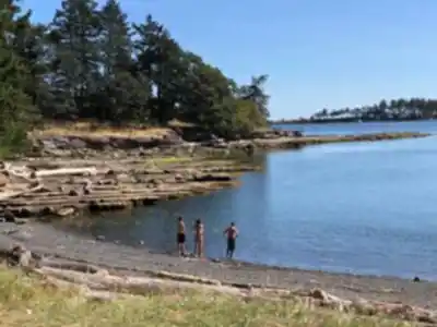
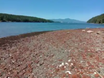
Coastal hiking represents some of Gabriola's best experiences. The island's numerous public beaches provide opportunities for extended shoreline walks, where hikers can explore tidal pools, watch for marine life, and enjoy unobstructed water views. The relatively flat terrain and gentle elevation changes make these routes accessible to hikers of all skill levels, with the modest elevation gains adding just enough challenge to keep things interesting without becoming strenuous.
The Hiking Experience
What makes Gabriola special is how the trails weave together different environments within a compact area. You might start your day walking through dense forest where Douglas fir and cedar create a cathedral-like canopy, then emerge onto open meadows where wildflowers bloom in spring and summer. The transition from forest to grassland happens gradually, giving you time to notice how the plant communities shift and change.
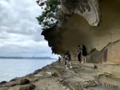
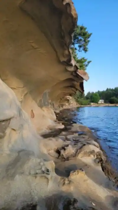
The coastal sections offer a completely different experience. Here, the trails follow the natural contours of the shoreline, sometimes climbing slightly for better viewpoints, other times dropping down to beach level where you can walk directly on sand or pebbles. The sound of waves becomes your constant companion, and on clear days, the views extend across the water to the mainland mountains.
The temperate climate means these coastal routes remain accessible year-round, though winter brings significantly more rainfall that can make some trails muddy and challenging. The island's position in the rain shadow of Vancouver Island's mountains means it receives less precipitation than many coastal areas, but waterproof footwear remains essential during the wetter months.
Access and Transportation
Reaching Gabriola requires planning around BC Ferries' schedule, with regular 20-minute ferry trips departing from Nanaimo harbour. This ferry connection makes the island far more accessible than many Gulf Islands, but hikers should still check sailing times and arrive early during peak summer months and festival periods when vehicle space fills quickly.
Once on the island, the established road network makes it relatively easy to reach different trailheads by car. The presence of shopping centres and restaurants means you can resupply or grab meals without returning to Nanaimo, extending your hiking time on the island. This infrastructure proves particularly valuable for multi-day visits when you want to explore different sections of the island without the logistical challenges that come with more remote destinations.
Seasonal Considerations
Gabriola's temperate climate creates distinct hiking seasons that each offer different advantages. Mild winters keep most trails accessible, but the substantial rainfall during these months means waterproof gear becomes essential. Many hikers find winter visits rewarding for storm watching along the coastline and experiencing the island's quieter side when tourist numbers drop.
Warm summers provide ideal conditions for extended hiking, though this coincides with peak visitor season. The island's cultural calendar becomes particularly busy during summer months, with major events like the Gabriola Theatre Festival in August drawing additional crowds that can affect ferry availability and accommodation options.
Spring and fall offer excellent compromise seasons. April brings the Isle of the Arts Festival, while October features the Thanksgiving Studio Tour, both providing opportunities to combine hiking with cultural experiences. Fall hiking benefits from clearer weather after summer's end and the chance to see the island's vegetation transition through autumn colors, particularly striking in the grassland areas where native plants put on impressive seasonal displays.
Cultural Integration
What sets Gabriola apart from other Gulf Island hiking destinations is how outdoor recreation integrates with the island's reputation as the "Isle of the Arts." The established artistic community creates a unique atmosphere where hiking trails might lead past studios and galleries, and where festivals throughout the year add cultural depth to outdoor visits.
The Gabriola Arts Council's three major annual events—the Isle of the Arts Festival in April, Gabriola Theatre Festival in August, and Thanksgiving Studio Tour in October—represent just the largest of many cultural activities. This means hikers can often combine trail time with gallery visits, live performances, or artist studio tours, creating a more diverse outdoor experience than typical wilderness hiking provides.
The island's several wineries add another dimension for hikers looking to extend their visit beyond the trails. These establishments often sit within the rural landscape that hiking routes traverse, making them natural stopping points during longer explorations of the island's network of interconnected paths and roads.
Wildlife and Natural Features
Gabriola's position in the Strait of Georgia creates rich opportunities for observing marine life during coastal hikes. The waters surrounding the island support diverse ecosystems that hikers can observe from shoreline trails, particularly during lower tides when more of the intertidal zone becomes visible. Seals, sea lions, and various seabirds are common sights, while lucky hikers might spot orcas or other marine mammals passing through the strait.
The island's mix of forest and grassland habitats supports varied bird populations, making it worthwhile to bring binoculars on hiking trips. The evergreen forests provide habitat for typical coastal BC species, while the more open grassland areas attract different bird communities. The transition zones between these habitats often prove particularly productive for wildlife viewing, as many species prefer these edge environments.
Planning Your Visit
The presence of bed and breakfasts, restaurants, and shops makes Gabriola suitable for multi-day hiking visits. Unlike more remote islands where camping might be the only overnight option, Gabriola's established tourism infrastructure supports various accommodation preferences and budgets.
Ferry scheduling remains the primary logistical consideration for any Gabriola hiking trip. The regular 20-minute crossing from Nanaimo provides predictable access, but hikers should build ferry wait times into their planning, especially during festival periods when the island's cultural events draw additional visitors to complement the outdoor recreation opportunities.
Recommended gear for this trail


Ready to go?
Everything you need to know before you goStarting Point
The gabriola island is located in British Columbia. To get to the start of the trails, take the ferry from Nanaimo to gabriola island.
The gabriola island is located in British Columbia. To get to the start of the trails, take the ferry from Nanaimo to gabriola island.
When?
How much?
- Hiking shoes Essential
- → Salomon Elixir Tour Mid WP · 203.38 $
- Layered clothing Essential
- Rain jacket Essential
- Trekking poles
- → Black Diamond Trail Ergo Cork · 69.99 $
- Headlamp
- → Petzl Actik Core 625 · 103.95 $
FAQ - Frequently asked questions
Everything you need to knowThe Essential Hiking Checklist
Everything you need for your next hike. Bilingual, printable, 1 page.
Download the free checklistSimilar hikes nearby
Discover other trails you might enjoy

Sandbar Trail
Vancouver Island

Old Baldy Mountain Trail
Vancouver Island
Wittys Lagoon
Vancouver Island
Mount Cain
Vancouver Island
Kings Peak
Vancouver Island
Buttle Lake
Vancouver Island
Hiking near Nanaimo
212 trails to explore ~11 km away
We work hard to provide the most up-to-date and error-free data possible. If something seems incorrect, let us know! Your contribution helps the whole community.
Hikers' opinions