

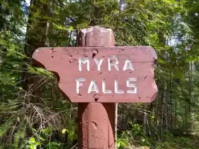
Ready to explore Lower Myra Falls? Here's everything you need to know before you go!
Discover the trail
Trail description
Description
Lower Myra Falls is one of those rare spots where the payoff is completely out of proportion to the effort required. Tucked inside Strathcona Provincial Park — British Columbia's oldest provincial park — on Vancouver Island, this waterfall delivers a genuinely impressive cascade without asking much in return. The round trip covers about 2 km with only 50 metres of elevation gain, and most hikers are back at the trailhead within an hour. That makes it one of the most rewarding easy hikes on the island.
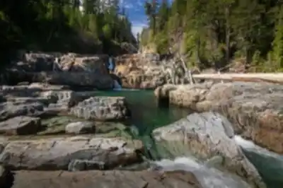
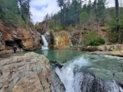
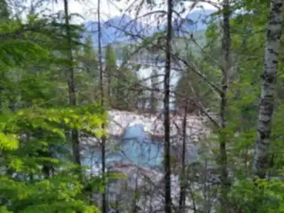
The falls are fed by Myra Creek, which drains the mountainous interior of Vancouver Island before emptying toward Buttle Lake. Lower Myra Falls drops over a series of rocky ledges in a multi-tiered display, carving through ancient bedrock into pools and channels shaped over thousands of years. The contrast between white churning water, dark rock, and the surrounding deep green forest is striking at any time of year.
The Trail
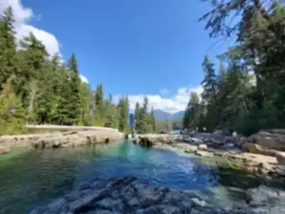
The path to the falls is short and well-maintained, winding through the coastal temperate rainforest that defines this corner of Vancouver Island. From the start, you're walking under a canopy of Douglas fir, western hemlock, and western red cedar — trees that have been growing here for centuries. The forest floor is thick with mosses and ferns, the kind of lush green understory that only happens where moisture is a constant presence.
The trail parallels portions of Buttle Lake's shoreline along the way, giving you glimpses of the lake's clear water reflecting the surrounding peaks. As you get closer to the falls, you'll hear them before you see them — the sound builds gradually, which adds to the anticipation.
Technically, the trail is straightforward. There are no steep climbs, no scrambling, and no route-finding challenges. That said, sections near the falls can get slippery, particularly when mist settles on rocks and wooden walkways. The path also has the typical uneven terrain of old-growth forest — exposed roots, forest duff, and occasional wet patches — so footwear with decent grip matters more than ankle support here.
What You'll See at the Falls
Lower Myra Falls puts on different shows depending on when you visit. Spring and early summer bring the highest water volume, when snowmelt from the park's interior pushes Myra Creek to its fullest. The falls roar during this period, and the mist can be significant enough to feel on your skin from the viewing areas. Late summer and fall dial back the volume but reveal more of the underlying rock structure — a different kind of beauty, and often better for photography since the spray isn't coating your lens.
The pools below the falls are a focal point regardless of season. The water takes on deep green and turquoise tones depending on light and depth, and the interplay between the white cascade and those still pools makes for compelling compositions from multiple angles. Early morning light filtering through the forest canopy adds warmth and depth that midday light can't match.
Wildlife in the area reflects the broader biodiversity of Strathcona Provincial Park. Steller's jays and Pacific wrens are common around the falls, and varied thrushes move through the forest understory. Black bears and Roosevelt elk inhabit the park, though the regular foot traffic near the falls means close encounters are uncommon.
Practical Notes
There are no facilities at the falls themselves, so bring water and anything else you need before you head out. The area near the falls has pleasant spots to sit and take in the view, which makes it a natural stopping point for a snack or a longer break.
Footwear with solid traction is the single most important gear consideration here. Trail runners or light hiking boots work well. Sandals or flat-soled shoes become a liability on wet rock near the falls.
Weather on Vancouver Island shifts quickly, and the forest environment near the falls stays damp even on dry days. A light rain layer is worth carrying regardless of the forecast.
What's Nearby
Lower Myra Falls connects naturally to the rest of what Strathcona Provincial Park has to offer. Upper Myra Falls lies further upstream and involves a more demanding hike, but rewards the extra effort with additional waterfall viewing and a deeper look into the Myra Creek drainage. For those wanting a full day out, Crest Mountain offers strenuous hiking with expansive views across the park's interior.
Buttle Lake itself is worth time before or after the hike. Kayaking, canoeing, and fishing are all popular on the lake, and several other trailheads around its perimeter open up different sections of the park. The lake's clarity and the mountain backdrop make it a destination in its own right, not just a landmark you pass on the way to the falls.
For a short trail, Lower Myra Falls delivers a concentrated version of everything that makes Vancouver Island's wilderness worth exploring — old-growth forest, dramatic water, and the kind of quiet that's harder to find closer to the coast.
Recommended gear for this trail


Ready to go?
Everything you need to know before you goStarting Point
The lower myra falls trailhead is located in the community of Myra Falls, British Columbia. To get there, take Highway 4 west from Campbell River to the community of Myra Falls. Turn left onto Myra Falls Road and drive to the end of the road. The trailhead is located at the end of the road.
When?
How much?
- Hiking shoes Essential
- → Salomon Elixir Tour Mid WP · 203.38 $
- Layered clothing Essential
- Rain jacket Essential
- Trekking poles
- → Black Diamond Trail Ergo Cork · 69.99 $
- Headlamp
- → Petzl Actik Core 625 · 103.95 $
FAQ - Frequently asked questions
Everything you need to knowThe Essential Hiking Checklist
Everything you need for your next hike. Bilingual, printable, 1 page.
Download the free checklistSimilar hikes nearby
Discover other trails you might enjoy

Sandbar Trail
Vancouver Island

Old Baldy Mountain Trail
Vancouver Island
Wittys Lagoon
Vancouver Island
Mount Cain
Vancouver Island
Kings Peak
Vancouver Island
Buttle Lake
Vancouver Island
Hiking near Nanaimo
212 trails to explore ~127 km away
We work hard to provide the most up-to-date and error-free data possible. If something seems incorrect, let us know! Your contribution helps the whole community.
Hikers' opinions