

Ready to explore North Pender Island? Here's everything you need to know before you go!
Discover the trail

Trail description
Description
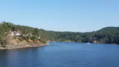
North Pender Island sits in the heart of the Southern Gulf Islands, reached by a short BC Ferries ride from Vancouver Island. What you get here is a compact island that punches well above its weight — dense coastal forests, rocky bluffs with sweeping water views, quiet lake country, and protected parkland all within easy reach of each other. The terrain tells the Pacific Northwest story in miniature, and the trails reflect that variety in a way that keeps every outing feeling fresh.
The combination of accessible routes and genuine wilderness character is what sets North Pender apart from other Gulf Islands destinations. You're never far from a viewpoint, a hidden lake, or a stretch of shoreline where the only sounds are wind and water. With around 12 kilometres of hiking spread across the island, a moderate 400 metres of elevation gain, and a comfortable 4.5-hour window to work with, you can cover meaningful ground without rushing.
Mount Norman
The hike to Mount Norman is the island's signature outing, and it earns that reputation. The trail starts in thick forest where western red cedar and Douglas fir form a cathedral canopy overhead. The climb is steady and consistent — you'll cross small creeks, work around moss-covered boulders, and move through sections where the understory opens up to reveal the dry coastal ecosystem that defines this part of British Columbia. The ascent requires real effort but stays well within reach for hikers with a basic level of fitness.
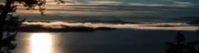
As you gain elevation, the forest gradually opens and the blue of the Strait of Georgia starts appearing through the trees. The summit delivers a full panoramic payoff — the Southern Gulf Islands archipelago spread out in every direction, individual islands scattered across the water, and the mainland mountains forming a hard edge on the horizon. The rocky summit provides natural seating, and most hikers spend a good stretch of time up here before heading back down.
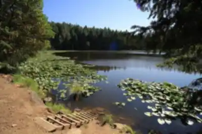
Roe Lake Trail
For something quieter, the Roe Lake Trail offers a completely different experience. The path meanders through mixed forest where the canopy filters light into shifting patterns on the ground. It feels intimate and enclosed in the best way — the kind of trail where you slow down naturally and start noticing details.
Roe Lake sits like a mirror in the forest, reflecting the surrounding trees and sky with almost unsettling clarity. The shoreline has several good spots to stop and watch for wildlife. Kingfishers, great blue herons, and various songbirds are regulars here, and the lake's stillness makes observation easy. The terrain stays relatively flat throughout, and the natural shade makes this a particularly good option during warmer months. Photographers and birdwatchers tend to gravitate toward this trail for good reason.
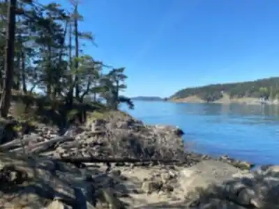
Gulf Islands National Park Reserve
Portions of North Pender Island fall within the Gulf Islands National Park Reserve, protecting some of the most ecologically significant terrain on the island. The park trails move through Garry oak meadows, coastal bluff communities, and rare plant ecosystems that exist in very few places in Canada. These aren't just scenic areas — they represent habitat that has been carefully protected precisely because of how unusual it is.
Trails within the park boundaries are well-maintained and clearly marked, with interpretive information along the way that adds context to what you're seeing. Some of these routes lead to viewpoints overlooking Active Pass, where BC Ferries vessels navigate the narrow channel between islands. Watching a ferry work through that tight passage from a quiet bluff above is one of those distinctly Gulf Islands moments that sticks with you.
Wildlife Along the Way
North Pender's position in the Strait of Georgia creates strong conditions for wildlife viewing across multiple habitat types. Bald eagles are a constant presence — perched in tall shoreline trees or riding thermals overhead. Along the rocky shores, harbour seals haul out regularly on sun-warmed rocks and tend to be unbothered by respectful observers at a reasonable distance.
The island's forests support black-tailed deer, various small mammals, and a solid range of bird species. The diversity of habitats — deep forest, open Garry oak meadows, lakeside edges, and coastal bluffs — means different wildlife communities occupy different parts of the island, and moving between trail types in a single day gives you a genuine cross-section of what lives here.
Getting There and Practical Notes
BC Ferries runs regular service to North Pender Island from Vancouver Island, making it a realistic day trip or a natural base for a longer stay. The ferry crossing itself is scenic and sets the tone before you even reach the trailhead. Once on the island, most trailheads are within easy driving distance of the ferry terminal and the island's accommodation options, which range from bed and breakfasts to camping facilities.
North Pender rewards a relaxed approach. The trails here aren't about covering maximum distance or chasing elevation records — they're about moving through ecosystems that feel genuinely distinct from the mainland and understanding why the Gulf Islands hold such a strong pull for hikers across the Pacific Northwest.
Recommended gear for this trail


Ready to go?
Everything you need to know before you goStarting Point
There is no public transportation to the north pender island. The only way to get there is by car or bike.
When?
How much?
- Hiking shoes Essential
- → Salomon Elixir Tour Mid WP · 203.38 $
- Layered clothing Essential
- Rain jacket Essential
- Trekking poles
- → Black Diamond Trail Ergo Cork · 69.99 $
- Headlamp
- → Petzl Actik Core 625 · 103.95 $
FAQ - Frequently asked questions
Everything you need to knowThe Essential Hiking Checklist
Everything you need for your next hike. Bilingual, printable, 1 page.
Download the free checklistSimilar hikes nearby
Discover other trails you might enjoy

Sandbar Trail
Vancouver Island

Old Baldy Mountain Trail
Vancouver Island
Wittys Lagoon
Vancouver Island
Mount Cain
Vancouver Island
Kings Peak
Vancouver Island
Buttle Lake
Vancouver Island
Hiking near Victoria
93 trails to explore ~40 km away
We work hard to provide the most up-to-date and error-free data possible. If something seems incorrect, let us know! Your contribution helps the whole community.
Hikers' opinions