

Ready to explore Sooke Potholes Provincial Park? Here's everything you need to know before you go!
Discover the trail
Trail description
Description
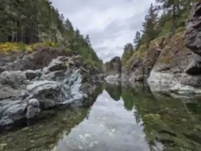
Sooke Potholes Provincial Park sits on the southern tip of Vancouver Island, where the Sooke River has spent thousands of years carving one of the region's most distinctive geological features. The park's namesake potholes are a series of deep, smooth-walled rock pools that the rushing river water has polished to an almost marble-like finish. These natural swimming holes range from shallow basins perfect for wading to deeper pools where you can take a proper dip during the warmer months.
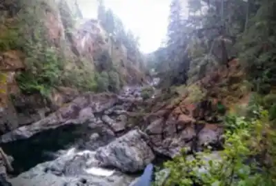
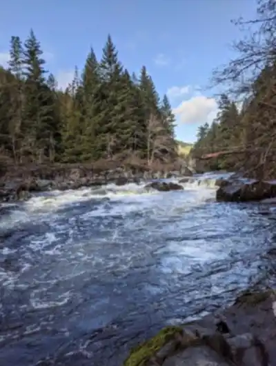
The potholes themselves are the main attraction, but they're just part of what makes this place special. The Sooke River flows through a landscape of weathered granite and metamorphic rock, creating a series of cascades, rapids, and calm stretches that change character with the seasons. In spring, snowmelt from the island's interior mountains swells the river, making the water features more dramatic but the swimming less appealing. By mid-summer, water levels drop to reveal more of the sculpted rock formations and create ideal conditions for cooling off in the pools.
Trail Network and Hiking Experience
The park offers several interconnected trails that wind through dense coastal forest and follow the riverbank. The main hiking route covers about 2 kilometers with minimal elevation gain of around 50 meters, making it an easy walk suitable for most fitness levels. You can comfortably complete the circuit in about an hour, though most visitors spend much longer exploring the various potholes and enjoying the water features.
The easier trails stay close to the main parking area and potholes, following well-maintained paths through second-growth Douglas fir and western red cedar forest. The terrain here is relatively flat and accessible, with wooden boardwalks and bridges crossing wet areas and small creeks. These paths are wide enough for families and offer frequent access points to the river.
For hikers wanting more of a workout, longer routes branch off into the surrounding hills, gaining elevation as they move away from the river. The terrain here shifts from the smooth riverside paths to rockier, root-crossed trails that require more attention to footing. These higher trails offer glimpses through the forest canopy toward the Strait of Juan de Fuca and the Olympic Mountains beyond.
The riverbank trails are particularly rewarding, as they give you multiple vantage points of the potholes and river features. You'll cross small wooden bridges over side creeks and navigate around large boulders that have tumbled down from the hillsides. The sound of moving water is constant, whether it's the main river flow or smaller streams trickling down to join the Sooke River.
The Geological Wonder
What sets this park apart from other swimming spots on Vancouver Island is the unique formation of the potholes themselves. The circular depressions were created through a process called pothole drilling, where swirling water carrying sand and small rocks gradually wore away the bedrock over millennia. The result is a series of perfectly round pools with smooth, curved walls that feel almost artificial in their precision.
Each pothole has its own character. Some are shallow and sun-warmed, perfect for children or those who prefer gentler water. Others plunge several meters deep, their dark blue-green depths inviting for confident swimmers. The connecting channels between pools create natural water slides and small rapids, though the current can be deceptively strong during high water periods.
Wildlife and Forest Ecosystem
The mix of forest and water habitats supports a diverse range of wildlife. Black-tailed deer are common throughout the park, often seen in the early morning or evening hours browsing in the understory. Bald eagles frequently soar overhead or perch in the tall conifers along the river, hunting for salmon during spawning season.
Black bears do inhabit the area, particularly during late summer when they're foraging for berries and preparing for winter. While encounters are relatively rare, it's important to make noise while hiking and properly store any food. The dense forest provides excellent habitat for smaller wildlife too – you might spot chipmunks, squirrels, and various songbird species as you explore the trails.
The forest itself tells the story of Vancouver Island's logging history. Much of what you see today is second-growth forest, but some impressive old-growth specimens remain, particularly in the more remote sections of the park. The understory is rich with salmonberry, huckleberry, and ferns that create a lush, green carpet beneath the towering conifers.
Swimming and Water Activities
The potholes are genuinely inviting for swimming, though the water temperature rarely gets truly warm even in peak summer. The deeper pools maintain a refreshing coolness that feels perfect after a hike on a hot day. The rock surfaces around the pools provide natural sunbathing spots, though they can be slippery when wet.
Different potholes offer different experiences. Some are shallow and perfect for children to splash around in, while others are deep enough for adults to swim properly. The water is typically clear enough to see the bottom, and the polished rock walls create an almost otherworldly swimming environment. The current in the connecting channels between pools can be swift, so it's important to assess conditions before entering the water.
Beyond swimming, the pools are popular for photography, with the smooth rock formations and clear water creating striking compositions. The interplay of light and shadow as sunlight filters through the forest canopy adds another dimension to the visual appeal of the potholes.
Practical Information and Access
The park is easily accessible from both Sooke and Victoria, making it a popular day trip destination. From Victoria, it's about a 45-minute drive west along Highway 14. The main parking area can fill up quickly on sunny summer weekends, so arriving early in the day is advisable.
Facilities include several parking areas of different sizes, with the main lot closest to the most popular potholes. Picnic tables are scattered throughout the park, both near the parking areas and along some of the trails. There are basic washroom facilities, but no potable water, so bring what you need for your visit.
The trails can be muddy during the wet season, which on Vancouver Island means roughly October through April. Good hiking boots with decent tread are recommended year-round, as the combination of wet rock and forest duff can be slippery. If you're planning to swim, bring towels and perhaps a change of clothes, as the rock surfaces don't offer much privacy for changing.
The park sees visitors year-round, but the character changes dramatically with the seasons. Summer brings crowds and the best swimming conditions, while winter visits offer solitude and the chance to see the potholes filled with rushing water from seasonal rains. Spring can be particularly beautiful when the forest understory is lush and green, and fall offers the chance to see salmon returning to spawn in the Sooke River.
Recommended gear for this trail


Ready to go?
Everything you need to know before you goStarting Point
The easiest way to get to the start of the trails at the sooke potholes provincial park is to drive to the park entrance on Gillespie Road and then follow the signs to the parking lot.
When?
Tuesday: 8:30 AM – 4:30 PM
Wednesday: 8:30 AM – 4:30 PM
Thursday: 8:30 AM – 4:30 PM
Friday: 8:30 AM – 4:30 PM
Saturday: 8:30 AM – 4:30 PM
Sunday: 8:30 AM – 4:30 PM
How much?
- Hiking shoes Essential
- → Salomon Elixir Tour Mid WP · 203.38 $
- Layered clothing Essential
- Rain jacket Essential
- Trekking poles
- → Black Diamond Trail Ergo Cork · 69.99 $
- Headlamp
- → Petzl Actik Core 625 · 103.95 $
FAQ - Frequently asked questions
Everything you need to knowTuesday: 8:30 AM – 4:30 PM
Wednesday: 8:30 AM – 4:30 PM
Thursday: 8:30 AM – 4:30 PM
Friday: 8:30 AM – 4:30 PM
Saturday: 8:30 AM – 4:30 PM
Sunday: 8:30 AM – 4:30 PM
The Essential Hiking Checklist
Everything you need for your next hike. Bilingual, printable, 1 page.
Download the free checklistSimilar hikes nearby
Discover other trails you might enjoy

Sandbar Trail
Vancouver Island

Old Baldy Mountain Trail
Vancouver Island
Wittys Lagoon
Vancouver Island
Mount Cain
Vancouver Island
Kings Peak
Vancouver Island
Buttle Lake
Vancouver Island
Hiking near Victoria
93 trails to explore ~26 km away
We work hard to provide the most up-to-date and error-free data possible. If something seems incorrect, let us know! Your contribution helps the whole community.
Hikers' opinions