

Ready to explore Mount Carleton? Here's everything you need to know before you go!
Discover the trail
Trail description
Description
Mount Carleton is the highest peak in the Maritime provinces, topping out at 820 meters (2,690 feet). It sits deep in the northern interior of New Brunswick, within the protected boundaries of Mount Carleton Provincial Park — a wilderness area covering over 17,000 hectares. If you're looking for a summit experience in Atlantic Canada, this is it. The landscape up here feels genuinely remote: vast stretches of boreal and Acadian forest, scattered lakes catching the light below, and ridgelines rolling off in every direction with almost no sign of human presence.
The Mount Carleton Trail
The main route to the summit is a 9.6 km hike with 853 meters of elevation gain, rated hard, and typically takes around 4 hours 30 minutes to complete. That's a significant day out — the elevation gain alone puts it in serious territory, and the terrain backs that up.
The trail starts in mixed hardwood and softwood forest — maple, birch, and spruce — and the first section is relatively forgiving. The path winds through the trees at a manageable grade, giving you time to warm up and settle into your pace. But the character of the hike shifts as you gain elevation. The forest transitions to predominantly coniferous species, the canopy thins, and the trail gets progressively rockier and steeper. You'll be stepping over exposed bedrock, navigating loose stones, and working through some genuine scrambles over larger boulders as you approach the top. Wet conditions make the upper sections noticeably more demanding, so traction matters.
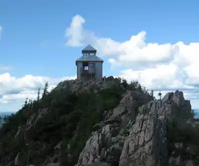
The payoff for all that effort is a summit view that earns its reputation. From the top of Mount Carleton, you're looking out over an unbroken expanse of forest in every direction, interrupted only by the glint of remote lakes and the distant ridgelines of other peaks within the park. On a clear day, the scale of what you can see is genuinely impressive — this is one of those summits where you actually feel like you've climbed somewhere.
Williams Falls Trail
Not every visit to the park needs to revolve around the summit. The Williams Falls Trail offers a completely different experience — a gentler, more relaxed walk through the forest that follows the sound of rushing water to a series of cascading falls. The terrain is relatively flat, making it a solid option for families, less experienced hikers, or anyone who wants to stretch their legs without committing to a hard day. The falls drop over weathered rock formations into natural pools, and the setting is particularly photogenic in the softer light of early morning or late afternoon. It also works well as a warm-up hike if you're planning to tackle the main summit the following day.
Wildlife and the Forest Environment
Mount Carleton Provincial Park is genuine wildlife habitat, and the remoteness of the location shows in what lives here. Moose are a regular presence, most often spotted in the early morning and evening when they move through wetland areas and forest clearings. Black bears also inhabit the park, so proper food storage and basic bear awareness are part of the deal for any visit.
Bird life is diverse across the park's forest types, from the chickadees and nuthatches you'll hear constantly in the mixed forest to warblers and birds of prey that use the larger protected area. The Acadian forest ecosystem supports a wide range of species, and the sheer size of the protected area gives wildlife room to move and behave naturally.
The forest itself changes noticeably with the seasons. Spring brings wildflowers pushing up through the forest floor as the canopy fills back in. Summer is full green, with the mixed forest at its densest. Autumn is when the hardwood component of the Acadian forest really delivers — the maples and birches turn the hillsides into a display of reds, oranges, and yellows that makes this one of the better fall hiking destinations in eastern Canada. The evergreens hold the structure of the landscape year-round.
Camping and Staying Overnight
The park has camping options for visitors who want more than a day trip. Staying overnight changes the experience significantly — you get the park during the quieter hours around dawn and dusk when wildlife is most active, and the dark skies this far from any urban center make for exceptional stargazing. The Milky Way is visible on clear nights in a way that simply isn't possible closer to populated areas. The ambient sounds of the wilderness — loons calling across distant lakes, the general quiet of a forest at night — are part of what makes an overnight stay here worth the extra planning.
Getting Ready for This Hike
Mount Carleton's remoteness and the difficulty of the main trail mean preparation isn't optional. Weather at elevation can shift quickly, so layered clothing and rain gear belong in your pack regardless of what the morning forecast looks like. Sturdy hiking boots with solid ankle support are important for the rocky upper sections of the trail. Carry more water than you think you'll need — the sustained effort of 853 meters of gain on a warm day will surprise you if you're underprepared.
Cell coverage in the park is limited to non-existent, which is part of the appeal but also a practical reality. Let someone know your plans and your expected return time before you head out. Check trail and weather conditions before you go, as the park's remote location means conditions can affect both accessibility and safety in ways that are harder to manage than at more developed hiking areas.
The park's size and protected status mean you're hiking in a place that's been set aside specifically to stay wild — and on the summit of Mount Carleton, standing above the highest point in the Maritimes with forest stretching to every horizon, that comes through clearly.
Recommended gear for this trail


Ready to go?
Everything you need to know before you goStarting Point
To access the hiking trails, head to mount carleton Provincial Park. The main trailhead is located at the park's visitor center, where you can find parking. The address for the visitor center is 7612 Route 385, Saint-Quentin, New Brunswick, E9A 1R9. From there, follow the signs to the various trailheads within the park.
When?
How much?
- Hiking shoes Essential
- → Salomon Elixir Tour Mid WP · 203.38 $
- Layered clothing Essential
- Rain jacket Essential
- Trekking poles
- → Black Diamond Trail Ergo Cork · 69.99 $
- Headlamp
- → Petzl Actik Core 625 · 103.95 $
FAQ - Frequently asked questions
Everything you need to knowThe Essential Hiking Checklist
Everything you need for your next hike. Bilingual, printable, 1 page.
Download the free checklistSimilar hikes nearby
Discover other trails you might enjoy

Hiking near Fredericton
11 trails to explore ~159 km away
We work hard to provide the most up-to-date and error-free data possible. If something seems incorrect, let us know! Your contribution helps the whole community.
Hikers' opinions