
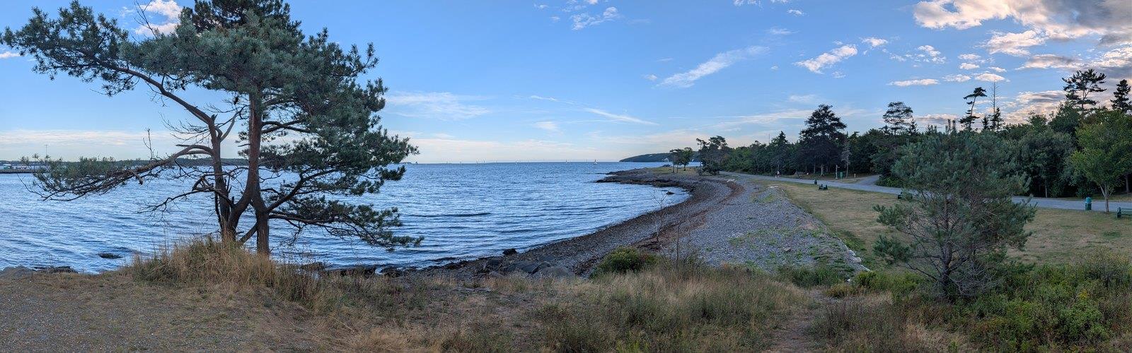

Ready to explore Point Pleasant Park? Here's everything you need to know before you go!
Discover the trail
Oh no! We don't have any photos 😢
This trail hasn't been captured yet. Be the first to share your adventure!Trail description
Point Pleasant Park sits at the southern tip of the Halifax Peninsula, where 75 hectares of dense forest meet the rocky Atlantic coastline. It's one of those rare urban parks that genuinely feels like wilderness — mature stands of spruce, fir, and hardwood close in around you within minutes of leaving the trailhead, and the sound of the city fades fast. The park's trail network stretches over 15 kilometres, giving you plenty of room to explore no matter how many times you've been here before.
Trail Network and Terrain
With 15 kilometres of trails and only 20 metres of total elevation gain, Point Pleasant Park sits firmly in the easy category. The terrain is forgiving throughout — the modest elevation change is spread across the entire network rather than concentrated in any single climb, so you're never grinding up a steep pitch. Expect to spend around an hour and fifteen minutes on a standard loop, though the sheer number of connecting paths makes it easy to extend or shorten your outing on the fly.
The trail system splits naturally into two distinct environments. The perimeter trail follows the shoreline for much of its length, running on wide, well-packed gravel that stays in good shape year-round. This is the route most visitors gravitate toward, and for good reason — it connects all the major landmarks and keeps Halifax Harbour in view for long stretches. Interior trails branch off into the forest and feel noticeably different: narrower, earthier, with exposed roots and the occasional muddy section after rain. The forest canopy keeps things cool in summer, and the understory fills in with wild blueberries, ferns, and seasonal wildflowers.
Trail intersections are well signed throughout the park, though the density of connecting paths can feel a bit like a puzzle on your first visit. The park's peninsular geography means getting seriously turned around is unlikely, but carrying a park map helps you navigate efficiently to specific destinations rather than wandering until something looks familiar.
Historical Features
Point Pleasant Park doubles as an outdoor museum of Halifax's military past, and the historical features are woven directly into the trail system rather than sitting off to the side. The Martello Tower, built in 1796, is the park's most recognizable landmark — a circular stone fortification that gives you a real sense of 18th-century defensive architecture and offers elevated views over the surrounding area.
Cambridge Battery is another standout, with earthwork fortifications and cannon emplacements positioned along the shoreline to protect Halifax Harbour. Interpretive signs at both sites explain the military significance clearly without being overwhelming. As you move through the park, you'll also come across additional remnants scattered through the forest: gun emplacements, bunkers, and foundation ruins that blend into the landscape in a way that rewards slow, attentive hiking.
Coastal Features and Wildlife
The shoreline alternates between rocky outcrops, small beaches, and protected coves over several kilometres. The rocky coast gives you solid vantage points for watching Halifax Harbour traffic — it's an active shipping channel, and there's usually something moving on the water. McNabs Island sits prominently offshore, and the downtown Halifax skyline frames the view to the north in a way that constantly reminds you how close to the city you actually are.
Wildlife is present throughout the park in a way that feels genuine rather than incidental. Red squirrels and chipmunks are common in the forest, and the varied habitat — dense woodland, open meadow, rocky shoreline — supports a solid range of songbirds. Coastal sections attract gulls, cormorants, and occasional osprey. During migration periods, the park becomes a notable stopover point, and local birding enthusiasts show up in numbers during peak windows. Early morning gives you the best chance of quiet wildlife encounters before the park fills up with other visitors.
Seasonal Conditions
The park is open year-round, and each season changes the experience meaningfully. Spring brings wildflower blooms and active bird migration, though trails can be muddy from snowmelt and rain — the interior paths especially. Summer is the most comfortable season for hiking, with full foliage providing shade and generally dry surfaces on both the coastal and forest trails.
Fall is when the hardwood sections earn their reputation, with red, orange, and yellow canopy making this one of the better seasons for photography and slower-paced walks. Winter hiking is doable, but the coastal location doesn't eliminate ice — it just moderates temperatures slightly. Proper footwear is essential once freeze-thaw cycles start, particularly on the rockier shoreline sections.
Access and Practical Information
The main entrance is located near the Tower Road gate, with parking areas that handle most visitor loads comfortably outside of busy weekend afternoons. The park's location at the southern end of the Halifax Peninsula makes it straightforward to reach by public transit from downtown, which takes pressure off the parking situation on peak days.
Dogs must remain leashed throughout the park, and owners are expected to clean up after their pets. The park's popularity — especially on summer weekends — means these rules matter for keeping the experience good for everyone. First-time visitors should budget a bit of extra time for navigation, not because the trails are confusing, but because the network is genuinely extensive and it's easy to add distance without realizing it.
Guided nature walks run through the warmer months, led by volunteers with solid knowledge of the park's ecology, history, and wildlife. These programs cover everything from military history to forest ecology to coastal environments, and they're worth checking out if you want more context for what you're seeing on the trail.
The Essential Hiking Checklist
Everything you need for your next hike. Bilingual, printable, 1 page.
Get your free hiking checklistRecommended gear for this trail
As an Amazon Associate I earn from qualifying purchases.


Ready to go?
Everything you need to know before you goStarting Point
The start of the trails at the point pleasant park in Nova Scotia can be accessed by driving to the park and parking in the lot. There is a map located at the entrance of the park that will show you where the trails are.
When?
How much?
As an Amazon Associate I earn from qualifying purchases.
Affiliate links — LGPO may earn a commission at no extra cost to you.
- Hiking shoes Essential
- → Salomon Elixir Tour Mid WP · 203.38 $
- Layered clothing Essential
- Rain jacket Essential
- Trekking poles
- → Black Diamond Trail Ergo Cork · 69.99 $
- Headlamp
- → Petzl Actik Core 625 · 103.95 $
FAQ - Frequently asked questions
Everything you need to knowSimilar hikes nearby
Discover other trails you might enjoy
Sandy Lake
Halifax Metro

Cranberry Lake
Halifax Metro

Rocky Lake Quarry
Halifax Metro
Kidston Lake
Halifax Metro

The Bluff Wilderness Hiking Trail Parking Lot.
Halifax Metro
Acadia Park
Halifax Metro
Hiking near Halifax
71 trails to explore ~2 km away
We work hard to provide the most up-to-date and error-free data possible. If something seems incorrect, let us know! Your contribution helps the whole community.
Hikers' opinions
Be the first to review!
No hiker has shared their experience yet. Share your impressions and help other hikers!