

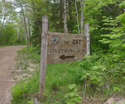
Ready to explore The Gut Conservation Area? Here's everything you need to know before you go!
Discover the trail
Available trails
| Trails | Distance | Elevation | Duration | Difficulty | GPX |
|---|---|---|---|---|---|
| 1.07 km | 51 m | 19min | GPX |
Trail description
Description
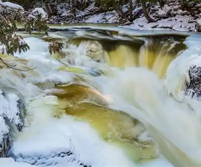
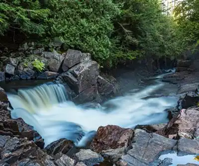
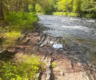
The Gut Conservation Area sits tucked into the Haliburton Highlands region extending toward the Ottawa Valley, and it delivers one of the more dramatic natural features you'll find in this part of Ontario. The centerpiece is a gorge where the Crowe River funnels through carved rock walls and drops in a powerful cascade—the kind of place where you hear it before you see it, and once you see it, you're not in a hurry to leave.
The waterfall has been cutting through this landscape for thousands of years, and the result is a narrow gorge with genuine visual impact. The rush of water echoing off the rock walls creates a natural amphitheater effect that makes the experience feel bigger than the trail distance might suggest. Spring runoff pushes the volume and intensity considerably, while late summer and fall pull back the water levels enough to expose more of the rock formations and the pool below—both versions are worth seeing.
Trail Experience
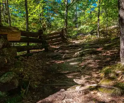
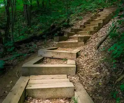
The trail system here is accessible and well-maintained, with an elevation gain of 52 meters that builds gradually rather than in any single punishing stretch. That makes this a solid choice for families, casual hikers, or anyone who wants a genuine natural payoff without a demanding physical commitment. Plan on about an hour and a half to move through the area properly, though the gorge viewpoints tend to slow people down in the best possible way.
The terrain has that characteristic Canadian Shield personality—rocky outcrops, slightly uneven footing, and a forest floor that keeps you paying attention without being technical. You move through sections of dense mixed forest where the canopy breaks the light into shifting patterns, then open up into areas where the broader landscape comes into view. As you get closer to the gorge, the sound of the water builds steadily, and the forest opens to reveal the drop where the river cuts through the rock.
Multiple vantage points around the gorge let you work the scene from different angles. Some give you a wide view of the full gorge system and the scale of the rock walls; others put you close enough to see the texture and movement of the water itself. It's worth taking the time to visit more than one of these spots rather than stopping at the first good view and turning back.
Natural Environment
The forest surrounding the gorge sits in the transitional zone between the Haliburton Highlands and the Ottawa Valley, which creates a mix of habitat types within a relatively compact area. Mature hardwoods dominate certain sections, while coniferous stretches give the trail that classic northern Ontario feel. That variety means the area reads differently depending on when you visit—spring brings emerging leaves and higher water, summer offers full canopy cover, fall delivers the color show this region is known for, and winter turns the waterfall into a layered ice formation.
Wildlife is present throughout, and the quieter nature of the trails means animals tend to be less skittish here than in higher-traffic areas. Chipmunks, squirrels, and various bird species are common companions on the trail. The mix of forest types and the presence of moving water creates habitat diversity that rewards anyone paying attention to what's moving in the trees or along the riverbank.
Photography and Scenic Viewing
The gorge is genuinely photogenic, and the multiple viewpoints mean you're not stuck working from a single angle. The contrast between the smooth moving water, rough rock walls, and surrounding forest gives you a lot to work with compositionally. Morning light hits certain faces of the gorge well, while afternoon sun does more for the forest canopy in the surrounding areas. Even with a smartphone, the natural framing and dramatic scale of the gorge make it easy to come away with strong images.
Beyond the waterfall itself, the rocky outcrops and forest floor offer plenty of detail work—bark textures, lichen patterns, the way water pools in rock depressions. It's the kind of place where photographers tend to stay longer than they planned.
Practical Considerations
Standard hiking footwear handles the maintained trails without issue. If you plan to explore closer to the water or move onto rocky areas near the gorge, something with decent grip makes a real difference—wet rock near a waterfall is exactly as slippery as it sounds. No specialized gear is required, but the basics apply: water, snacks, and layers suited to the weather.
The riverbank areas offer natural spots to take a break or eat lunch, and the sound of the waterfall provides solid background ambiance for it. The area is relatively secluded, so finding a quiet spot to sit and watch the water isn't difficult. Stay on the designated trail system, particularly near the gorge—it protects the surrounding ecosystem and keeps you on the right side of the drop. Pack out what you bring in.
Recommended gear for this trail


Ready to go?
Everything you need to know before you goStarting Point
the gut conservation area is located in Ontario. To get to the start of the trails, take Highway 401 to exit 496 and go north on County Road 2 for about 9 km. The entrance to the conservation area will be on your left.
When?
How much?
- Hiking shoes Essential
- → Salomon Elixir Tour Mid WP · 203.38 $
- Layered clothing Essential
- Rain jacket Essential
- Trekking poles
- → Black Diamond Trail Ergo Cork · 69.99 $
- Headlamp
- → Petzl Actik Core 625 · 103.95 $
FAQ - Frequently asked questions
Everything you need to knowThe Essential Hiking Checklist
Everything you need for your next hike. Bilingual, printable, 1 page.
Download the free checklistSimilar hikes nearby
Discover other trails you might enjoy

Grace Lake
Haliburton Highlands to the Ottawa Valley
Adventure Trail Gear
Haliburton Highlands to the Ottawa Valley
Gould Lake
Haliburton Highlands to the Ottawa Valley
Mazinaw Lake
Haliburton Highlands to the Ottawa Valley
Kamaniskeg Lake
Haliburton Highlands to the Ottawa Valley
Murphys Pinnacle, Ontario
Haliburton Highlands to the Ottawa Valley
Hiking near Barrie
146 trails to explore ~150 km away
We work hard to provide the most up-to-date and error-free data possible. If something seems incorrect, let us know! Your contribution helps the whole community.
Hikers' opinions