

Ready to explore Sentier Martel? Here's everything you need to know before you go!
Discover the trail
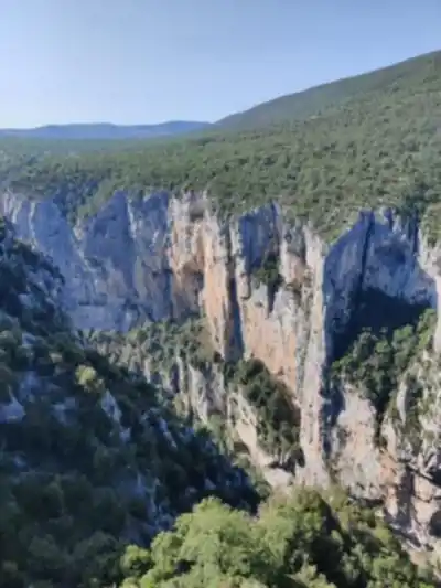
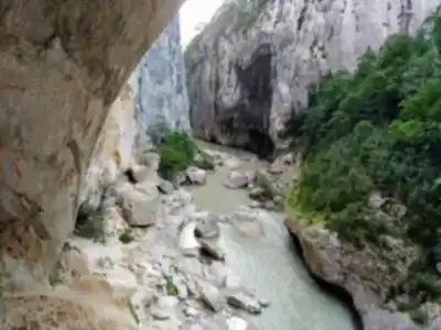
3
community photos

Trail description
Désolé, nous n'avons pas de description pour cet endroit.
Soyez le premier à partager plus d'informations sur cet endroit.
Soyez le premier à partager plus d'informations sur cet endroit.
Recommended gear for this trail
LGPO Pick

Salomon
Elixir Tour Mid WP
Waterproof mid-height boot ideal for rocky terrain
203.38 $


Affiliate links — LGPO may earn a commission at no extra cost to you.
Ready to go?
Everything you need to know before you goAddress
Not available
GPS coordinates
43.74665830000001, 6.345528499999999
Phone
Not available
When?
Opening hours
Open 24 hours every day
Varies by season
Best season
Fall
Spectacular colors
Best time
Early morning
Less crowded
Weather (next days)
Loading
How much?
Entry fees
Adult
Not available
Child
—
What to bring?
Gear
- Hiking shoes Essential
- → Salomon Elixir Tour Mid WP · 203.38 $
- Layered clothing Essential
- Rain jacket Essential
- Trekking poles
- → Black Diamond Trail Ergo Cork · 69.99 $
- Headlamp
- → Petzl Actik Core 625 · 103.95 $
Water & food
2L minimum
No water point on the trail
Bring energy snacks for a 4h+ hike
Good to know
Park rules
No dogs
Safety
Download the GPX before you go
Limited cellular coverage on the trail
Slippery after rain
Be careful on rocky sections
In an emergency
Emergency
911
Parking GPS
43.74665830000001, 6.345528499999999
Center
Not available
FAQ - Frequently asked questions
Everything you need to knowHard
600.00 m
1204.00 m
5h30
No
No
No, Sentier Martel is rated as a hard difficulty trail and is not suitable for beginners. The 15 km distance combined with 600 m of elevation gain and 5h30 duration requires good physical fitness and hiking experience. Only attempt this trail if you have solid outdoor skills and stamina.
Sentier Martel takes approximately 5h30 to complete. This timeframe assumes a moderate pace and may vary depending on your fitness level, experience, and trail conditions.
Sentier Martel is 15 km long. Combined with the 600 m elevation gain, this makes it a challenging full-day hike that requires proper preparation and adequate time.
The best time to hike Sentier Martel is typically late spring through early autumn when weather conditions are most stable and daylight hours are longest. Check current conditions with local authorities before your visit, as alpine weather can change rapidly.
Didn't find your answer?
Free
1 pages
The Essential Hiking Checklist
Everything you need for your next hike. Bilingual, printable, 1 page.
Download the free checklistSimilar hikes nearby
Discover other trails you might enjoy

Top 10 best hiking in Alpes-de-Haute-Provence
Our ranking based on hiker reviews
Hiking near Sydney
22 trails to explore ~5100 km away
Did you spot an error?
We work hard to provide the most up-to-date and error-free data possible. If something seems incorrect, let us know! Your contribution helps the whole community.
Hikers' opinions