

Ready to explore Mount Hopkins, California? Here's everything you need to know before you go!
Discover the trail
Trail description
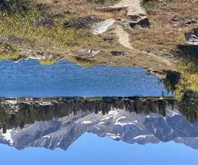
Mount Hopkins is a serious High Sierra objective located in California's Sierra Nevada range within Inyo National Forest, in the John Muir Wilderness area north of Kings Canyon National Park. With 24 km of total distance, 3,750 m of elevation gain, and an estimated 12 hours and 15 minutes on the mountain, this is firmly in very hard territory — the kind of day that demands honest preparation and a genuine respect for high-altitude terrain. This is a climbing route, not a casual trail hike, and the numbers reflect that.
What to Expect on the Route
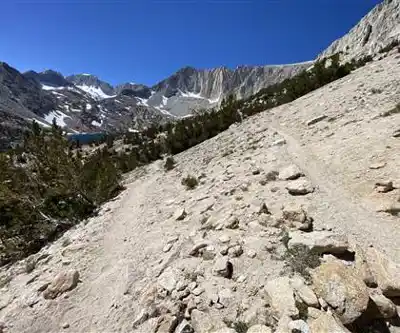
The sheer elevation gain here is the defining characteristic of this objective. At nearly 3,750 meters of vertical, you're looking at a sustained effort from the trailhead all the way to the summit. The Sierra Nevada doesn't hand out summits easily, and Mount Hopkins is no exception. Expect a mix of trail, talus, and exposed ridgeline as you gain altitude. The terrain gets progressively more demanding the higher you go, and above treeline the route becomes more technical and route-finding dependent.
The 24 km round-trip distance means you'll be covering significant ground even before factoring in the vertical. Pace yourself early — the temptation to move fast on the lower sections can cost you dearly when the real climbing begins. Most parties who complete this route in the estimated 12-hour window are moving efficiently and have prior experience on Sierra peaks.
Terrain and Conditions
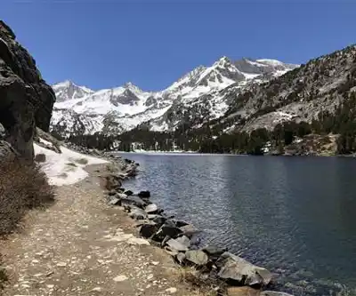
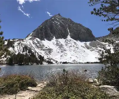
The Sierra Nevada is known for its granite, and Mount Hopkins delivers that classic High Sierra character: solid rock, dramatic exposure, and views that stretch across ridgelines and valleys in every direction. The lower sections typically pass through conifer forest before opening up into the rocky alpine zone. Once you're above treeline, the landscape shifts entirely — sparse vegetation, open sky, and the kind of silence that only comes with real elevation.
Snow can linger on north-facing slopes and upper sections well into summer. Depending on the year and the time of your visit, an ice axe and crampons may be necessary in early season. Always check current conditions before heading out — the Sierra snowpack varies significantly from year to year, and what's a straightforward scramble in August can be a serious mountaineering undertaking in May or June.
Who This Route Is For
This is not a beginner hike. The combination of distance, elevation gain, and technical terrain puts Mount Hopkins squarely in the realm of experienced hikers and peak baggers who are comfortable on Class 2 or Class 3 terrain. If you've done other High Sierra summits and know how your body handles altitude and sustained effort, you'll be in the right headspace for this one.
That said, strong intermediate hikers who train regularly and have some experience with off-trail Sierra travel can absolutely take this on — just be realistic about your fitness level and build in extra time rather than rushing the descent.
Practical Tips
- Start early: A 12-hour day means a pre-dawn start is standard. Afternoon thunderstorms are common in the Sierra during summer, and you want to be off exposed ridgelines well before they build.
- Water: Carry more than you think you need. High-output days at altitude burn through hydration fast. A filter or purification tablets let you top up from Sierra streams and snowmelt along the way.
- Navigation: Above treeline, trail markers disappear. Bring a downloaded topo map and know how to use it. GPS is helpful but not a substitute for map literacy on a route like this.
- Permits: This route is in Inyo National Forest and may require a wilderness permit. Check current regulations with Inyo National Forest before your trip.
- Layers: Temperatures at summit elevation can drop sharply even on warm days. A wind layer and insulating mid-layer are non-negotiable.
- Leave No Trace: The alpine zone is fragile. Stay on rock where possible, pack out everything, and give wildlife a wide berth.
- Tell someone your plan: Cell service is unreliable in the High Sierra. Let a contact know your trailhead, your route, and your expected return time.
The Payoff
Routes this demanding exist because the reward matches the effort. The High Sierra above 3,000 meters offers a kind of landscape that's hard to find anywhere else in the continental United States — raw granite, sky, and a perspective on the range that only comes from earning the elevation. Mount Hopkins delivers that experience in full.
Recommended gear for this trail


Ready to go?
Everything you need to know before you goStarting Point
To access the hiking trails, you can start at the main trailhead located at the end of Mount Hopkins Road. The parking area is available there for hikers. Additionally, another possible starting point is at the intersection of Forest Route 5N03 and Mount Hopkins Road, where limited roadside parking may be available. Ensure to check local maps for precise navigation and any potential restrictions or seasonal closures.
When?
How much?
- Hiking shoes Essential
- → Salomon Elixir Tour Mid WP · 203.38 $
- Layered clothing Essential
- Rain jacket Essential
- Trekking poles
- → Black Diamond Trail Ergo Cork · 69.99 $
- Headlamp
- → Petzl Actik Core 625 · 103.95 $
FAQ - Frequently asked questions
Everything you need to knowThe Essential Hiking Checklist
Everything you need for your next hike. Bilingual, printable, 1 page.
Download the free checklistSimilar hikes nearby
Discover other trails you might enjoy

Bloody Mountain, California
Sierra Nevada
Mount Ingalls, California
Sierra Nevada
Mount Lyell, California
Sierra Nevada
Vernal and Nevada Falls (The Mist) Trail
Sierra Nevada
Chinese Peak, California
Sierra Nevada
Basin Mountain, California
Sierra Nevada
Hiking near Victoria
93 trails to explore ~1273 km away
We work hard to provide the most up-to-date and error-free data possible. If something seems incorrect, let us know! Your contribution helps the whole community.
Hikers' opinions
Be the first to review!
No hiker has shared their experience yet. Share your impressions and help other hikers!