

Ready to explore Mount Lyell, California? Here's everything you need to know before you go!
Discover the trail
Trail description
Description
At 13,114 feet, Mount Lyell is the highest peak in Yosemite National Park — and one of the most serious mountaineering objectives in the entire Sierra Nevada. This isn't a peak you wander up on a whim. The combination of 32 kilometers of approach terrain, nearly 4,000 meters of elevation gain, and technical glacier travel puts it firmly in a different category from most California hikes. If you're ready for that challenge, few experiences in the range come close to matching it.
The Approach: Tuolumne Meadows to the High Country
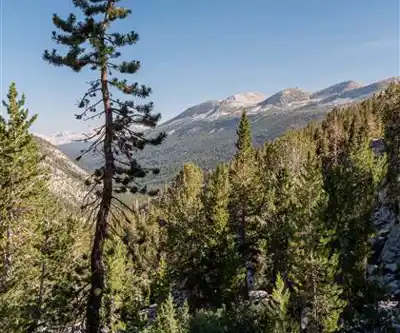
The route starts at Tuolumne Meadows, one of the most accessible entry points into Yosemite's high country. From the trailhead, the early miles feel almost gentle — wide subalpine meadows, wildflowers in season, and the sound of streams running clear over granite. It's easy to underestimate what's ahead when the terrain is this inviting.
That changes as you gain elevation. The meadows give way to open granite slabs, boulder fields, and a series of alpine lakes that sit in polished basins carved by glaciers long gone. These lakes are genuine highlights of the approach — calm, reflective, and completely removed from the crowds that fill Yosemite Valley far below. Marmots are a constant presence on the warmer granite benches, and deer are frequently spotted grazing near water sources in the early morning hours.
The approach itself covers enough varied terrain that it functions as a full Sierra Nevada experience before you even reach the technical portion of the route. By the time the upper mountain comes into view, you've already traveled through multiple distinct ecosystems and logged serious mileage.
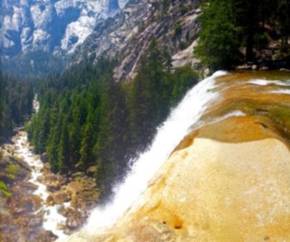
The Technical Section: Lyell Glacier
The final push to the summit crosses the Lyell Glacier, and this is where Mount Lyell separates itself from everything else in the park. Glacier travel requires a specific skill set — crampons, ice axe, and rope are not optional here, they're the baseline. The glacier's angle and condition vary by season, but the exposure is real regardless of when you go.
Above the glacier, steep rocky terrain and loose scree demand careful footwork and sustained focus. The elevation compounds everything: at this altitude, your pace slows, recovery takes longer, and decision-making requires more deliberate effort. The 14.5-hour estimated duration reflects this reality — it accounts for the careful movement required across technical ground, not just the raw distance.
Weather is the other major variable. Conditions at this elevation can shift from clear to dangerous in a short window, and the exposed upper mountain offers no natural shelter. Layers, emergency gear, and a conservative turnaround time are non-negotiable parts of the plan.
Summit Views
From the top, the panorama takes in Yosemite's full granite landscape — the iconic formations, the deep valleys, and the vast wilderness stretching in every direction across the Sierra Nevada. The perspective is genuinely different from anything you get at lower elevations. You're looking down on peaks that feel large from the trail, and the scale of the range becomes tangible in a way that's hard to describe from below.
The summit also carries real historical weight. Generations of Sierra Nevada climbers have made this same push, and standing on Yosemite's highest point connects you to that long tradition of California mountaineering.
Logistics and Preparation
Mount Lyell rewards thorough preparation and punishes shortcuts. A few things worth knowing before you commit:
- High camp strategy: Many climbers break the route into two days by establishing a high camp on the approach. This makes the summit day more manageable and reduces the risk of being caught in afternoon weather at elevation.
- Gear requirements: Crampons, ice axe, and rope are required for the glacier section. This is mountaineering terrain, not a scramble.
- Water: Sources are generally reliable along the lower approach, but carry sufficient water for the technical upper sections where you won't find reliable resupply.
- Early season conditions: Significant snow and ice can persist well into summer, affecting both the approach and the glacier. Late season brings its own hazards, including unstable glacier conditions and increased rockfall.
- Self-sufficiency: Emergency evacuation from the upper mountain would be extremely difficult. Conservative decision-making isn't just good practice here — it's essential.
What Makes Mount Lyell Worth It
What sets Mount Lyell apart from other demanding Sierra Nevada objectives is the completeness of the experience. The route moves through every layer of the high country — from the open meadows of Tuolumne to remote cirques and high basins that see very little traffic, and finally onto technical alpine terrain that demands real mountaineering competence. You're not just climbing a peak; you're traveling through a full cross-section of the Sierra Nevada landscape.
The remote upper mountain also offers a quality of quiet that's increasingly rare in a park as visited as Yosemite. Up here, the sounds of the valley are completely gone. What replaces them — wind moving across granite, the occasional distant rumble of rockfall — has a way of resetting your sense of scale and proportion in ways that stay with you long after you're back at the trailhead.
Recommended gear for this trail


Ready to go?
Everything you need to know before you goStarting Point
To access the hiking trails, you can start from the Tuolumne Meadows area in Yosemite National Park. The primary trailhead is located at the Lyell Canyon Trailhead, which is accessible from the Tuolumne Meadows Campground parking lot. The address for Tuolumne Meadows is Tioga Road (Highway 120), Yosemite National Park, CA 95389. Be sure to check for any seasonal road closures or park entry requirements before your visit.
When?
How much?
- Hiking shoes Essential
- → Salomon Elixir Tour Mid WP · 203.38 $
- Layered clothing Essential
- Rain jacket Essential
- Trekking poles
- → Black Diamond Trail Ergo Cork · 69.99 $
- Headlamp
- → Petzl Actik Core 625 · 103.95 $
FAQ - Frequently asked questions
Everything you need to knowThe Essential Hiking Checklist
Everything you need for your next hike. Bilingual, printable, 1 page.
Download the free checklistSimilar hikes nearby
Discover other trails you might enjoy

Mount Hopkins, California
Sierra Nevada
Mount Ingalls, California
Sierra Nevada
Bloody Mountain, California
Sierra Nevada
Vernal and Nevada Falls (The Mist) Trail
Sierra Nevada
Chinese Peak, California
Sierra Nevada
Basin Mountain, California
Sierra Nevada
Hiking near Victoria
93 trails to explore ~1233 km away
We work hard to provide the most up-to-date and error-free data possible. If something seems incorrect, let us know! Your contribution helps the whole community.
Hikers' opinions