


Ready to explore Appalachian Trail CT? Here's everything you need to know before you go!
Discover the trail
Oh no! We don't have any photos 😢
This trail hasn't been captured yet. Be the first to share your adventure!Trail description
The Appalachian Trail in Connecticut is one of the most rewarding stretches of the entire 2,190-mile footpath that runs from Georgia to Maine. Connecticut's section cuts through the northwestern corner of the state, winding through dense hardwood forests, open ridgelines, and quiet river valleys that feel genuinely remote despite being within reach of major northeastern cities. If you've only ever thought of Connecticut as suburbs and shoreline, this trail will change your mind fast.
What the Trail Looks Like on the Ground
The Connecticut portion of the Appalachian Trail runs through Litchfield County, passing through some of the most rugged and least-developed terrain in the state. The trail follows the classic white blaze markers the entire way, so navigation is straightforward. What's not always straightforward is the terrain itself — Connecticut's AT is known for its rocky footing, rooted paths, and some genuinely steep climbs that catch first-timers off guard.
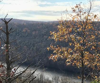
The trail crosses the Housatonic River twice and spends significant time along its banks, offering flat, easy walking through floodplain forest that contrasts sharply with the ridge sections. The river corridor is peaceful and scenic, with the water visible through the trees for long stretches. Then the trail climbs back up into the hills, and you're back to picking your way over exposed rock and navigating through mountain laurel thickets that bloom brilliantly in late spring.
Highlights along the Connecticut AT include Lion's Head, a rocky summit with open views to the west and one of the most satisfying viewpoints on the entire state section. Bear Mountain, the highest peak on Connecticut's AT, offers a 360-degree panorama and a stone monument at the summit. The climb is steep and rocky, but the payoff is real. Rand's View and St. Johns Ledges are other standout spots — the ledges in particular involve a scramble that adds some genuine adventure to the day.
Terrain and Conditions
Connecticut's AT is not a groomed trail. Expect exposed roots, wet rocks, and sections where the path narrows considerably. Trekking poles are genuinely useful here, especially on the descents. The rocky ridgeline sections drain well and tend to be drier underfoot, but the river valley portions and low-lying areas can be muddy after rain, sometimes significantly so.
The trail passes through state forests and state parks, including Housatonic Meadows State Park and Macedonia Brook State Park, as well as land managed by the Appalachian Trail Conservancy and the National Park Service. This patchwork of management means conditions and facilities vary depending on where you are on the trail.
Water sources exist along the route, including streams and the Housatonic River, but all water should be treated before drinking. There are designated campsites and lean-tos spaced along the trail for those doing multi-day sections, including Limestone Spring Lean-to and Pine Swamp Brook Lean-to. Camping is restricted to designated sites — dispersed camping off-trail is not permitted in most areas.
Access and Trailheads
The Connecticut AT can be accessed at multiple trailheads along its length. Popular entry points include the parking area at Falls Village, the trailhead near Salisbury for the Bear Mountain and Lion's Head section, and access points along Route 341 near Kent. Parking is available at several of these access points, though lot sizes are limited and popular trailheads fill up early on weekends, particularly in fall and during peak spring hiking season.
The trail enters Connecticut from the south at the New York border near Pawling and exits to the north into Massachusetts near Sages Ravine. Day hikers typically focus on specific segments rather than attempting the full state crossing in one go.
Who This Trail Is For
The Connecticut AT rewards hikers who are comfortable on uneven, rocky terrain and who don't need a perfectly smooth path to enjoy themselves. It's not the right choice for a casual first hike or for anyone expecting a well-maintained, wide trail. That said, the difficulty varies considerably by section — the Housatonic River corridor sections are genuinely easy and accessible, while the ridge climbs to Bear Mountain or up to Lion's Head are legitimately challenging.
For experienced day hikers, the Bear Mountain and Lion's Head loop is a classic Connecticut outing. For those looking to do a multi-day section hike, the Connecticut AT offers a satisfying chunk of the larger trail with enough variety — river walking, ridge hiking, rocky scrambles, quiet forest — to keep things interesting throughout.
Wildlife and Natural Features
The forests along Connecticut's AT are predominantly northern hardwood — maple, beech, birch, and oak — with hemlock stands in the ravines and along stream corridors. Mountain laurel is everywhere and makes the trail genuinely spectacular when it blooms, typically in June. Black bears are present in the area, so proper food storage is important for anyone camping overnight. White-tailed deer are common, and the Housatonic River corridor supports a variety of bird species that make it a worthwhile stretch for anyone who pays attention to what's moving in the trees.
Practical Notes
- Dogs: Dogs are permitted on the Appalachian Trail in Connecticut but must be kept on leash in certain areas, particularly within state park boundaries. Check current regulations for the specific section you're hiking.
- Bikes: Bicycles are not permitted on the Appalachian Trail.
- Fees: No fee is required to hike the Appalachian Trail in Connecticut. Some adjacent state park areas may have separate fee structures.
- Camping: Overnight camping is permitted only at designated sites and lean-tos along the trail.
- Leave No Trace: The AT in Connecticut sees significant use — pack out everything you bring in and stay on the marked trail to protect the surrounding vegetation.
The Appalachian Trail Conservancy and local trail maintaining clubs, including the AMC Connecticut Chapter and the Connecticut Forest and Park Association, maintain the Connecticut section and are good resources for current trail conditions before you head out.
The Essential Hiking Checklist
Everything you need for your next hike. Bilingual, printable, 1 page.
Get your free hiking checklistRecommended gear for this trail
As an Amazon Associate I earn from qualifying purchases.


Ready to go?
Everything you need to know before you goWhen?
How much?
As an Amazon Associate I earn from qualifying purchases.
Affiliate links — LGPO may earn a commission at no extra cost to you.
- Hiking shoes Essential
- → Salomon Elixir Tour Mid WP · 203.38 $
- Layered clothing Essential
- Rain jacket Essential
- Trekking poles
- → Black Diamond Trail Ergo Cork · 69.99 $
- Headlamp
- → Petzl Actik Core 625 · 103.95 $
FAQ - Frequently asked questions
Everything you need to knowSimilar hikes nearby
Discover other trails you might enjoy

Hiking near Poughkeepsie
0 trails to explore ~37 km away
We work hard to provide the most up-to-date and error-free data possible. If something seems incorrect, let us know! Your contribution helps the whole community.
Hikers' opinions
Be the first to review!
No hiker has shared their experience yet. Share your impressions and help other hikers!